Iowa Crop Progress and Condition Report
Aug. 11 – 17, 2025
DES MOINES, Iowa (Aug. 18, 2025) – Iowa Secretary of Agriculture Mike Naig commented on the Iowa Crop Progress and Condition Report released by the USDA National Agricultural Statistics Service. The report is released weekly April through November. Additionally, the Iowa Department of Agriculture and Land Stewardship provides a weather summary each week during this time.
“Warm and muggy conditions didn’t deter visitors from enjoying another successful Iowa State Fair,” said Secretary Naig. “Drier weather in western Iowa broke an eight-week streak of unseasonably wet conditions, and for the first time in over a year, Iowa’s drought map is free of drought and abnormal dryness. The outlook through the end of August suggests cooler temperatures and more seasonal rainfall potential.”
The weekly report is also available on the USDA’s website at nass.usda.gov.
Crop Report
Scattered precipitation across the State allowed Iowa’s farmers 5.1 days suitable for fieldwork during the week ending August 17, 2025, according to the USDA, National Agricultural Statistics Service. Field activities included harvesting oats and hay and a few reports of fungicide and insecticide applications.
Topsoil moisture condition rated 0 percent very short, 2 percent short, 72 percent adequate and 26 percent surplus. Subsoil moisture condition rated 0 percent very short, 4 percent short, 73 percent adequate and 23 percent surplus.
Nearly all of Iowa’s corn has reached the silking stage. Corn in the dough stage reached 78 percent, 1 day behind last year’s pace and 3 days behind normal. Corn in the dent stage reached 27 percent, 1 day ahead of last year, but 1 day behind the five-year average. Corn condition rated 1 percent very poor, 2 percent poor, 11 percent fair, 56 percent good and 30 percent excellent. Soybeans blooming reached 96 percent. Eighty-three percent of soybeans were setting pods, 1 day ahead of last year’s pace, but 4 days behind normal. Soybean condition rated 1 percent very poor, 2 percent poor, 15 percent fair, 60 percent good and 22 percent excellent. Ninety-one percent of the oat for grain crop has been harvested.
The third cutting of alfalfa hay reached 65 percent complete. Pasture condition rated 83 percent good to excellent. Frequent rains have kept pastures growing and extended grazing periods. Livestock were generally in good condition, with a few reports of stress caused by heat and humidity.
Weather Summary
Provided by Justin Glisan, Ph.D., State Climatologist, Iowa Department of Agriculture and Land Stewardship
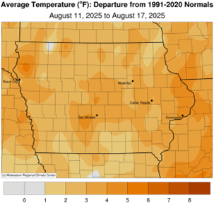
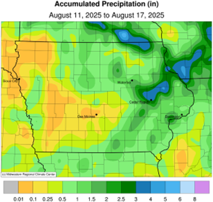
While parts of eastern Iowa saw above normal rainfall during the reporting period, this was the first week since mid-June in which statewide precipitation was below normal. Unseasonably warm and muggy conditions also persisted with positive departures in the two-to-four degree range; the statewide average temperature was 74.8 degrees, 2.9 degrees above normal.
Thunderstorms producing moderate to heavy rainfall across eastern Iowa finally exited the state early on Sunday (10th) afternoon. Nearly 20 stations observed at least 2.00 inches from east-central to northeast Iowa; Waterloo (Black Hawk County) collected 2.10 inches while 3.10 inches was reported at Dubuque Lock and Dam (Dubuque County). Daytime temperatures ranged from the low 70s north to low 80s south with lingering showers in western Iowa. Isolated strong storms reformed in eastern Iowa towards evening but fell apart after sunset. Scattered showers and thunderstorms developed in southeastern Iowa through the day on Monday (11th) as afternoon temperatures held in the upper 70s and low 80s. Some storms became severe in extreme southeast Iowa with two weak and short-lived tornadoes observed in Lee County. Rainfall was observed over Iowa’s southeastern one-third with widespread 0.50-1.00 inch totals; the highest amounts were found in a swath from south-central to eastern Iowa with 1.18 inches in Ottumwa (Wapello County) to 2.20 inches in Parnell (Iowa County). Stations farther north and west reported a few tenths of an inch. Patchy fog was reported at daybreak on Tuesday (12th) with lows in the upper 50s northwest to low 70s southeast. Skies remained mostly sunny with afternoon temperatures held in the low 80s as a cold front dropped southeast through the state. Winds shifted northeasterly behind the front with overnight lows dropping into the mid 50s to low 60s west to east. Daytime conditions were pleasant with light winds, lower relative humidity and temperatures in the upper 70s and low 80s.
Winds shifted to a southeasterly direction into Thursday (14th) as scattered showers pushed across parts of Iowa with numerous stations registering a tenth of an inch or less. Winds became blustery through the day as a low pressure center approached the Upper Midwest. Clouds increased into Friday (15th) morning as a small complex of thunderstorms propagated into northwestern Iowa from South Dakota. In the presence of ample moisture and instability, the complex expanded into a severe-warned bow echo and sped across northern Iowa before banking southeast into eastern Iowa by the evening hours. There were several reports along the path of the storms of large hail and wind gusts above 60 mph; 72 mph gusts were observed at La Porte City (Black Hawk County) and East Amana (Iowa County). The strongest part of the line moved out of eastern Iowa by sundown with scattered thunderstorms popping in northeast Iowa. Multiple stations along the swath observed totals above 0.75 inch with two stations in Vinton (Benton County) registering 1.72 to 2.07 inches. Amounts on the periphery were from a few to several tenths of an inch, particularly in northwest, central and eastern Iowa. Saturday (16th) was generally a quiet day, though unseasonably hot with daytime temperatures in the upper 80s and low 90s under bright sunshine. Nearly stationary thunderstorms formed on an existing boundary along the Iowa-Wisconsin border into Sunday (17th) morning. Decorah Municipal Airport (Winneshiek County) observed 1.02 inches while Decorah’s National Weather Service co-op station reported 2.90 inches.
Weekly precipitation totals ranged from no accumulation at a few western Iowa stations to 5.01 inches in Monticello (Jones County). The statewide weekly average precipitation was 0.80 inch, while the normal is 0.93 inch. Guttenberg Lock and Dam (Clayton County) reported the week’s high temperature of 98 degrees on the 17th, 16 degrees above normal. Spencer Municipal Airport (Clay County) reported the week’s low temperature of 53 degrees on the 13th, seven degrees below normal.