Iowa Crop Progress and Condition Report
July 10-16, 2023
DES MOINES, Iowa (July 17, 2023) – Iowa Secretary of Agriculture Mike Naig commented today on the Iowa Crop Progress and Condition Report released by the USDA National Agricultural Statistics Service. The report is released weekly April through November. Additionally, the Iowa Department of Agriculture and Land Stewardship provides a weather summary each week during this time.
“Iowa received much needed and widespread rainfall last week, along with some unfortunate, isolated reports of crop damage from strong winds, hail and a few weak tornadoes in southwest Iowa,” said Secretary Naig. “Scattered storms are possible early in the week, with seasonal temperatures and precipitation expected to return as corn continues to tassel across the state.”
The weekly report is also available on the USDA’s website at nass.usda.gov.
Crop Report
Much-needed rain fell across most of Iowa, resulting in farmers having 4.7 days suitable for fieldwork during the week ending July 16, 2023, according to the USDA, National Agricultural Statistics Service. Field activities included cutting hay and harvesting oats. Some reports were received of farmers starting to apply fungicides.
Topsoil moisture condition rated 8 percent very short, 35 percent short, 55 percent adequate and 2 percent surplus. Subsoil moisture condition rated 15 percent very short, 40 percent short, 43 percent adequate and 2 percent surplus.
Corn silking hit 49 percent this week, 5 days ahead of last year and 2 days ahead of normal. Eight percent of the corn crop has reached the dough stage, 8 days ahead of last year and 6 days ahead of the 5-year average. Corn condition improved to 64 percent good to excellent. Sixty-eight percent of soybeans were blooming, 1 week ahead of last year and 5 days ahead of the average. Soybeans setting pods reached 17 percent, 3 days ahead of last year but equal to the 5-year average. Soybean condition rose to 58 percent good to excellent. Eighty-six percent of oats were turning color, 11 days ahead of last year and 6 days ahead of normal. Oats harvested for grain reached 13 percent, 1 day behind the five-year average. Oat condition rated 51 percent good to excellent.
The State’s second cutting of alfalfa hay reached 74 percent complete, 1 week ahead of last year and 6 days ahead of the average. Reports were received of farmers working on their third cutting of hay. Hay condition improved to 41 percent good to excellent. Pasture condition rose to 30 percent good to excellent. Recent precipitation helped to improve hay and pasture condition, although growth remains slow and below average.
Weather Summary
Provided by Justin Glisan, Ph.D., State Climatologist, Iowa Department of Agriculture and Land Stewardship
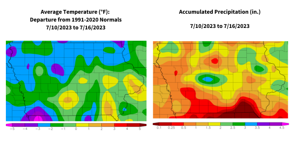
Iowans experienced the wettest reporting period since early May, as widespread rainfall was coupled with wind and hail from severe thunderstorms. Dense wildfire smoke also returned at week’s end, blotting out the sky and creating a copper-colored sun. Conditions remained cooler than normal with a statewide average temperature of 72.2 degrees, 2.7 degrees below normal.
Light, variable winds developed through Sunday (9th) afternoon with a brilliant blue sky and daytime highs in the upper 70s and low 80s. A southerly shifting wind held lows in the upper 50s and low 60s as the sun rose on Monday (10th). Temperatures climbed into the upper 80s across northern Iowa as scattered severe thunderstorms formed during the late afternoon hours and pushed east. A few more cells developed before midnight but diminished during the early hours of Tuesday (11th). A swath of stations across far northern Iowa picked up decent rainfall totals, ranging from 0.53 inch at Sanborn (O’Brien County) to 1.39 inches in Milford (Dickinson County). Daytime temperatures varied from the low 70s north to the upper 80s south as showers developed over northern Iowa later in the day. Clouds increased overnight ahead of a potent squall line rapidly forming over southern South Dakota and northeastern Nebraska. The line crossed into northwest Iowa around sunrise on Wednesday (12th) as a secondary downstream wave intensified and sped through central Iowa. Both waves had large bowing segments with severe-warned thunderstorms, producing damaging straight-line wind gusts and a few weak tornadoes in Harrison and Pottawattamie Counties. Torrential downpours were also observed as the then combined disturbance cleared eastern Iowa by noon. Winds shifted northwesterly behind the low-pressure center with highs in the upper 70s west to low 80s east under lingering clouds.
Event rain totals reported at 7:00 am on Thursday (13th) showed widespread and beneficial totals across most of Iowa with over 200 stations measuring at least an inch; 45 stations observed two inches or more with three stations in Boone County reporting between 4.00 and 4.55 inches. The statewide average rainfall from the system was 1.11 inches, producing the wettest 24-hour stretch of the growing season thus far. Morning fog burned off over sections of north-central Iowa as southwesterly winds developed under partly cloudy skies and temperatures reaching into the low to mid 80s. Isolated severe storms fired across north-central Iowa later in the afternoon and persisted over northeastern Iowa into Friday (14th) morning. Most stations in the northeast quadrant of Iowa received general totals in the 0.25-0.50-inch range with higher totals along the Iowa-Minnesota border; Lake Mills (Winnebago County) observed 1.00 inch while New Hampton (Chickasaw County) measured 2.16 inches. Another system brought showers through Iowa’s western half into the afternoon with a stronger line of storms firing in eastern Iowa later in the evening. Some of the storms turned severe with 1.00-inch-sized hail near Monmouth (Jackson County) and higher intensity rainfall rates; Strawberry Point (Clayton County) registered 0.51 inch with 1.84 inches in Monticello (Jones County). Clouds and hazy conditions persisted over northern Iowa into Saturday (15th) morning with lows in the mid-50s north to mid-60s south. Pervasive Canadian wildfire smoke returned to the Midwest, mixing down into the lower atmosphere and causing poor air quality issues across Iowa. Daytime temperatures remained in the low 80s as smoke decreased the amount of incoming sunlight to the surface. An isolated severe thunderstorm fired near New Hampton later in the afternoon, quickly dissipating after leaving behind 0.10 inch of rain. Smoky haze continued into Sunday (16th) morning with temperatures in the 50s to 60s north to south.
Weekly precipitation totals ranged from 0.12 inch in Bloomfield (Davis County) to 5.29 inches in Nora Springs (Floyd County). The statewide weekly average precipitation was 1.24 inches, while the normal is 1.05 inches. Several southern stations reported the week’s high temperature of 93 degrees on the 11th, on average six degrees above normal. Audubon (Audubon County) reported the week’s low temperature of 46 degrees on the 10th, 16 degrees below normal.