Iowa Crop Progress and Condition Report
November 21 - 27, 2022
DES MOINES, Iowa (November 29, 2022) — Iowa Secretary of Agriculture Mike Naig commented today on the Iowa Crop Progress and Condition Report released by the USDA National Agricultural Statistics Service. The report is released weekly April through November.
“In the face of challenging weather conditions and economic uncertainty, Iowa farmers once again showed their resiliency by producing yet another strong crop. With harvest nearly complete, Iowa farmers are looking ahead to next year by considering input choices and conservation practices, and making decisions about marketing,” said Secretary Naig. “Wet conditions would be welcome in the weeks ahead to help chip away at precipitation deficits and to replenish our soil moisture levels.”
The weekly report is also available on the USDA’s website at nass.usda.gov.
Crop Report
Farmers closed the season with 6.2 days suitable for fieldwork during the week ending November 27, 2022, according to the USDA, National Agricultural Statistics Service. Warmer weather allowed tillage and fertilizer applications. There were reports of a few scattered corn fields remaining to be harvested.
Topsoil moisture condition rated 23 percent very short, 33 percent short, 43 percent adequate and 1 percent surplus. The 56 percent short to very short topsoil moisture rating is the highest percentage of short to very short to close out the season since 2012 when 72 percent fell into the short to very short categories. Subsoil moisture condition rated 30 percent very short, 35 percent short, 34 percent adequate and 1 percent surplus.
Livestock were doing well with reports of calves being weaned and cattle grazing on corn stalks.
Weather Summary
Provided by Justin Glisan, Ph.D., State Climatologist, Iowa Department of Agriculture and Land Stewardship
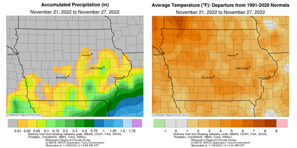
A generally quiet weather pattern brought warmer than average temperatures across Iowa during the last reporting period of the growing season. Positive temperature departures of up to six degrees were observed with a statewide average temperature of 36.5 degrees, 4.9 degrees above normal. Rainfall was light across southeastern Iowa with no measurable totals over northern Iowa.
Gusty southwesterly winds continued under clear skies through Sunday (20th) afternoon, helping boost highs into the upper 30s northeast to low 50s southwest. Skies remained cloudless overnight with morning lows on Monday (21st) in the low 20s to low 30s with some spotty clouds in south-central Iowa. Winds shifted back to a northerly direction through the day as an upper-level trough pushed through the Midwest. Daytime highs warmed into the upper 40s and low 50s in southern Iowa while temperatures held in the 30s north. Stars were visible into Tuesday (22nd) morning with low temperatures in the upper teens to upper 20s north to south. A return of southerly flow pushed high temperatures into the mid to upper 50s across most of Iowa. Cloudless skies persisted on Wednesday (23rd) with temperatures in the upper teens to mid 20s. Afternoon conditions were unseasonably warm with highs in the mid to upper 50s; the statewide average high was 55 degrees, 13 degrees above normal. Cloud cover streamed into southwestern Iowa ahead of a low pressure center early on Thursday (24th) with foggy conditions observed in northern and eastern Iowa where temperatures were in the 30s; clouds held temperatures in the 40s southwest. Spotty light rain showers formed as a cold front swept west to east, clearing skies in western Iowa and shifting winds to the northwest. Ahead of the front, highs reached into the mid 50s with 40s registering behind the boundary. Isolated rain totals were reported at several stations with a general range of 0.01 to 0.05 inch in the southeast; a station near Drakesville (Davis County) measured 0.15 inch.
Clouds cleared eastern Iowa by midnight with low temperatures bottoming out in the 20s statewide. Light southwesterly winds built in through Friday (25th) as pleasant daytime conditions continued. Afternoon temperatures held in the low 50s over much of Iowa as clear skies reigned. Overnight lows early on Saturday (26th) stayed above freezing over much of northwestern Iowa with upper 20s and low 30s registering at southern stations. Blustery winds developed through the late morning and early afternoon hours before diminishing towards the evening. Daytime highs were generally in the 40s with pockets of 50s observed in south-central Iowa. A low pressure center moving through Missouri spun rain showers through southern Iowa later in the evening and into Sunday (27th) morning. Many stations receiving rain registered under 0.10 inch with a swath of heavier totals in southeastern Iowa where showers held on; a few stations in Lee County measured totals from 0.28 inch in Donnellson to 0.65 in Augusta.
Weekly precipitation totals ranged from no accumulation at stations across Iowa’s northwestern half to 0.69 inch at Keokuk Lock and Dam (Lee County). The statewide weekly average precipitation was 0.03 inch while the normal is 0.41 inch. Sioux City Airport (Woodbury County) reported the week’s high temperature of 63 degrees on the 26th, 22 degrees above normal. Fayette (Fayette County) reported the week’s low temperature of seven degrees on the 21st, 15 degrees below normal. Four-inch soil temperatures were in the mid 30s northeast to low 40s southwest.