Iowa Crop Progress and Condition Report for May 6 - May 12
DES MOINES, Iowa (May 13, 2024) – Iowa Secretary of Agriculture Mike Naig commented on the Iowa Crop Progress and Condition Report released by the USDA National Agricultural Statistics Service. The report is released weekly April through November. Additionally, the Iowa Department of Agriculture and Land Stewardship provides a weather summary each week during this time.
“Planters continue to be parked across much of the state. Widespread wet conditions last week have delayed planting progress and it’s certainly weighing on the minds of farmers,” said Secretary Naig. “We need sunshine and light breeze to get back into the field. Although chances of thunderstorms remain in the forecast, conditions are trending warmer and quieter mid to late week. Once the conditions are right, farmers will get back to planting.”
The weekly report is also available on the USDA’s website at nass.usda.gov.
Crop Report
Rain across Iowa early in the week held farmers to just 1.7 days suitable for fieldwork during the week ending May 12, 2024, according to the USDA, National Agricultural Statistics Service. Iowa farmers reported planting corn, soybeans, and applying pesticides late in the week.
Topsoil moisture condition rated 1 percent very short, 7 percent short, 71 percent adequate and 21 percent surplus. Subsoil moisture condition rated 4 percent very short, 17 percent short, 67 percent adequate and 12 percent surplus.
Fifty-seven percent of Iowa’s expected corn crop has been planted, 1 week behind last year and 5 days behind the 5-year average. Twenty-six percent of the corn crop has emerged. Iowa’s farmers have planted 39 percent of Iowa’s expected soybean crop, 1 week behind last year and 4 days behind the normal. Thirteen percent of the soybean crop has emerged. Ninety-eight percent of the expected oat crop has been planted while emergence reached 81 percent, 2 days ahead of last year and 5 days ahead of the 5-year average. There were reports of oats headed in isolated areas of the State.
Hay condition rated 77 percent good to excellent. There were a few reports of producers beginning their first cutting of hay. Pasture condition rated 67 percent good to excellent. Cattle feedlots were muddy due to rain received over the past four-week period.
Weather Summary
Provided by Justin Glisan, Ph.D., State Climatologist, Iowa Department of Agriculture and Land Stewardship
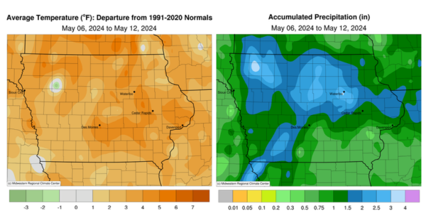
For the fourth consecutive reporting period, Iowa observed unseasonably wet conditions with positive departures in the 1.00-3.00-inch range across the state’s northern half. Temperatures were also warmer than the 30-year climatology with the warmest readings approaching four degrees; the statewide average temperature was 60.6 degrees, 2.0 degrees above normal.
Sunday (5th) afternoon conditions were pleasant with mostly sunny skies and temperatures in the mid to upper 60s. Clouds increased across southern Iowa into Monday (6th) with lows ranging from the upper 40s north to upper 50s south. A southerly shifting wind brought warmer and more humid air into the state in advance of a strong low pressure system spinning over the Dakotas. Instability increased as a warm front pushed north over southwestern Iowa, providing atmospheric energy for the low’s attendant cold front to fire a long line of strong thunderstorms; the complex entered western Iowa during the evening hours with multiple severe thunderstorm and tornado warnings into central Iowa. Two EF-1 tornadoes spun up near Glenwood (Mills County) and at multiple locations in Pottawattamie County along with straight line wind reports. Moderate to heavy rain also fell as the line advanced rapidly to the east along with additional high wind reports. Rain totals reported at 7:00 am on Tuesday (7th) were highest in southwestern Iowa though nearly 140 stations across the state’s western half picked up at least an inch. Forest City (Winnebago County) registered 2.04 inches while 2.60 inches was observed in Corning (Adams County); the statewide average was 0.85 inch with totals generally under 0.75 inch in eastern Iowa. Gusty southwesterly winds developed behind the system with partly cloudy skies and daytime highs in the upper 60s and low 70s. Isolated thunderstorms formed over central Iowa into the evening hours before dissipating as they pushed east. Wednesday (8th) dawned with variable winds and low temperatures generally in the 50s. Daytime skies were partly to mostly cloudy south with temperatures reaching into the upper 70s and low 80s. Another low spinning over the Upper Midwest fired thunderstorms, a few producing hail and strong winds, across northwest and then central Iowa through the evening before the storms overspread northern Iowa after midnight.
Thursday (9th) morning rain totals highlighted a pocket of 1.00-2.00-inch readings across several counties in central to north-central Iowa. Algona (Kossuth County) observed 1.58 inches, Iowa Falls (Hardin County) hit 1.80 inches with 1.92 inches in Mason City (Cerro Gordo County); much of northern Iowa received at least 0.25 inch with a statewide average of 0.44 inch. Showers persisted in eastern Iowa through the day with some embedded thunderstorms, one of which spun up a brief land spout near Charles City (Floyd County) along with 2.01 inches of rain. Northwesterly winds held with temperatures varying from the low 70s southwest to mid 50s northeast where rain was present. Several stations in Black Hawk County observed over an inch of rain with many stations reporting 0.20 to 0.40 inch. Clear skies and light winds allowed fog to form near daybreak on Friday (10th). As the disturbance pushed east, mostly sunny skies and gusty westerly winds built in with highs in the 70s. Clear skies persisted through Saturday (11th) with mid to upper 70s returning in the afternoon. Winds swung around to a southern direction into Sunday (12th) morning with pockets of cloud cover in northeastern Iowa and low temperatures dropping into the 50s.
Weekly precipitation totals ranged from 0.25 inch at Columbus Junction (Louisa County) to 3.67 inches in Sanborn (O’Brien County) and near Waterloo (Black Hawk County). The statewide weekly average precipitation was 1.51 inches, while the normal is 1.00 inch. Davenport Municipal Airport (Scott County) reported the week’s high temperature of 83 degrees on the 8th, 13 degrees above average. Marshalltown (Marshall County) reported the week’s low temperature of 33 degrees on the 6th, 11 degrees below normal. Four-inch soil temperatures were in the low to mid 60s statewide as of Sunday.