Iowa Crop Progress and Condition Report
Oct. 5-11, 2026
DES MOINES, Iowa (Oct. 13, 2026) - Iowa Secretary of Agriculture Mike Naig commented on the Iowa Crop Progress and Condition Report released by the USDA National Agricultural Statistics Service. The report is released weekly April through November. Additionally, the Iowa Department of Agriculture and Land Stewardship provides a weather summary each week during this time.
“Harvest is in full swing across Iowa but farmers are continuing to battle wet field conditions following one of the wettest Septembers on record,” said Secretary Naig. “Farmers took advantage of last week’s warm, mostly dry weather to get combines rolling and make significant harvest progress. With more favorable weather in the forecast, we expect another busy week as farmers keep combines moving, seed cover crops and tackle other fall farm work.”
Crop Report
There were 5.5 days suitable for fieldwork during the week ending Oct. 11, 2026. Topsoil moisture condition rated 5 percent short, 72 percent adequate, and 23 percent surplus. Subsoil moisture condition rated 6 percent short, 72 percent adequate, and 22 percent surplus. Ninety-five percent of corn has reached maturity, which is on par with the five-year average. Fourteen percent of corn has been harvested, which is 20 percentage points behind the five-year average. Corn condition rated 71 percent good to excellent. Ninety-four percent of soybeans are dropping leaves, which is 2 percentage points behind the five-year average. Thirty-one percent of soybeans have been harvested, which is 28 percentage points behind the five-year average. Soybean condition rated 69 percent good to excellent. Pasture condition rated 72 percent good to excellent.
The weekly report is also available on the USDA’s website at https://esmis.nal.usda.gov/publication/crop-progress.
Weather Summary
Provided by Justin Glisan, Ph.D., State Climatologist, Iowa Department of Agriculture and Land Stewardship
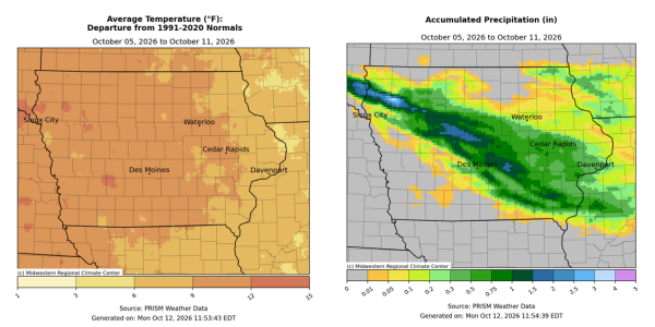
After four consecutive reporting periods with above-average rainfall, the first full week of October was unseasonably dry across the state. Thunderstorms brought heavy rain and sizable hail along a northwest to southeast swath, while many stations dried out through the week. Temperatures were also substantially above normal with positive departures nearing 15 degrees at some locations; the statewide average temperature was 65.5 degrees, 9.0 degrees above normal.
Pleasant conditions persisted through Sunday (4th) afternoon with ample sunshine, light northerly winds and temperatures in the low to mid 70s. Skies remained clear into Monday (5th), allowing morning lows to drop into the low 40s with calm to light, variable winds. Winds shifted to a southerly direction through the day with 70s statewide, cloudless skies and low relative humidity. Southerly winds continued through Tuesday (6th) helping low temperatures rise into the upper 50s across western Iowa. Gusty conditions developed into the afternoon hours with temperatures in the mid to upper 70s east to low to mid 80s west and increasing low level moisture transport. Winds gradually died down and shifted northwesterly as a cold front dropped through the state into the overnight hours as temperatures held in the 50s across much of the state; morning lows dipped into the mid 40s in northwestern Iowa behind the front. Wednesday (7th) continued a string of nice days with sunshine and daytime highs in the 70s over much of Iowa; low 80s were observed across southern Iowa with slightly higher dewpoints than stations farther north.
Thursday (8th) dawned with generally calm winds and morning lows in the mid 40s with some clouds over central Iowa. A warm front draped across southwestern Iowa slowly propagated north through the day, with airmass conditions south of the boundary warmer and more humid. Showers developed over the Iowa-South Dakota border by the evening hours, with strong isolated thunderstorms firing along the northwest-southeast oriented surface front. Several storms produced very tall updrafts which supported sporadic large hail reports from Plymouth County to Dallas County; reports were in the 1.00-1.50 inch diameter range with a 1.75 inch sighting near Wall Lake (Sac County) and in Cumming (Warren County). Heavy rainfall was also observed along the swath with 35 stations at or over 1.00 inch; Orange County (Sioux City) had 1.51 inches, 1.91 inches in Gilbert (Story County) and 1.93 inches in Cherokee (Cherokee County). Friday (9th) began clear with breezy easterly winds turning southerly into the afternoon hours, helping boost temperatures from the mid 80s across central Iowa to low 90s southwest. Saturday (10th) morning was warm, dry and clear statewide with morning temperatures from the upper 50s east to upper 60s west. The daytime hours were quite warm, in the mid to upper 80s, as southerly winds increased and skies remained cloudless; the statewide average high was 85 degrees, 20 degrees above normal. Temperatures remained unseasonably warm into Sunday (11th) with low 60s northwest to low 50s southeast under starlit skies and light southerlies.
Weekly precipitation totals ranged from no measurable totals at numerous stations to 1.93 inches in Cherokee (Cherokee County). The statewide weekly average precipitation was 0.55 inch, while the normal is 0.69 inch. Sioux City Airport (Woodbury County) reported the week’s high temperature of 93 degrees on the 10th, 27 degrees above normal. Spencer Municipal Airport (Clay County) reported the week’s low temperature of 36 degrees on the 5th, six degrees below normal.