Iowa Crop Progress and Condition Report
Oct. 12-18, 2026
DES MOINES, Iowa (Oct. 19, 2026) - Iowa Secretary of Agriculture Mike Naig commented on the Iowa Crop Progress and Condition Report released by the USDA National Agricultural Statistics Service. The report is released weekly April through November. Additionally, the Iowa Department of Agriculture and Land Stewardship provides a weather summary each week during this time.
“With the historically wet September, Iowa's harvest got off to a late start, and our farmers are a good two weeks behind on their normal progress,” said Secretary Naig. “Most of the state experienced favorable weather conditions last week allowing farmers to make headway, where field conditions allowed. With unseasonably warm, mostly dry weather in the forecast this week, farmers should have more opportunities to keep harvest moving. As activity picks up, I remind drivers to watch for farm equipment, slow down and be patient. A successful harvest means everyone gets home safely at the end of the day.”
Crop Report
There were 4.6 days suitable for fieldwork during the week ending Oct. 18, 2026. Topsoil moisture condition rated 3 percent short, 73 percent adequate, and 24 percent surplus. Subsoil moisture condition rated 5 percent short, 74 percent adequate, and 21 percent surplus. Ninety-eight percent of corn has reached maturity, which is even with the five-year average. Twenty-six percent of corn has been harvested, which is 24 percentage points behind the five-year average. Corn condition rated 72 percent good to excellent. Ninety-seven percent of soybeans are dropping leaves, which is 2 percentage points behind the five-year average. Fifty-seven percent of soybeans have been harvested, which is 17 percentage points behind the five-year average. Pasture condition rated 73 percent good to excellent.
The weekly report is also available on the USDA’s website at https://esmis.nal.usda.gov/publication/crop-progress.
Weather Summary
Provided by Justin Glisan, Ph.D., State Climatologist, Iowa Department of Agriculture and Land Stewardship
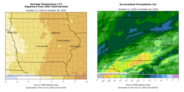
The first widespread frost and freeze occurred over much of Iowa towards the end of the reporting period, with lows falling into the upper 20s at multiple stations. Rainfall was also above-normal for pockets of the state as multiple systems brought longer-duration rainfall. Temperatures remained above normal with positive departures nearing nine degrees in eastern Iowa; the statewide average temperature was 56.9 degrees, 5.4 degrees above normal.
Sunday (11th) afternoon and Monday (12th) were summerlike days with highs in the upper 80s to low 90s with southerly winds and sunny skies; the statewide average high was 87 degrees, 21 degrees above normal. Morning lows into Tuesday (13th) varied from the upper 40s west to low 60s east as clouds advanced from the west, covering the state by the late afternoon hours. Isolated thunderstorms moved through southern Iowa during the morning hours, with numerous stations reporting a few tenths of an inch with a pocket of higher totals southeast; Fort Madison (Lee County) collected 0.91 inch. Overcast conditions persisted through the day with additional thunderstorms popping up in eastern Iowa into the late afternoon hours. Additional storms fired over extreme southeast Iowa after sunset. Several stations near Burlington (Des Moines County) reported more than an inch, with totals ranging from 1.05 inches to 1.41 inches at the Burlington Municipal Airport. The highest total of 1.52 inches was found at the National Weather Service co-op station in Augusta (Lee County). Northerly winds and cloudy skies held into Wednesday (14th) with morning temperatures in the mid 40s north to low 60s south. Winds turned easterly as two low pressure centers approached Iowa from the west. Daytime temperatures rose into the 50s across much of the state with 60s along the Iowa-Illinois border. Showers pushed into western Iowa around midnight and overspread much of the state by late morning on Thursday (15th) and continued over most of the daylight hours. Afternoon temperatures only rose into the 50s as blustery northwesterly winds built in as the low’s attendant cold front swept through the state. Nearly 100 stations reported an inch or more with the highest totals in north-central to eastern Iowa; Cedar Falls (Black Hawk County) registered 1.51 inches with 1.56 inches in Boone (Boone County) and 2.77 inches in Eagle Grove (Wright County). With high pressure building across the Upper Midwest in close proximity to the exiting low pressure center, strong northerly winds developed into Friday (16th). Isolated showers also produced drizzle and light rain throughout the day with highs hovering in the low 50s. Starry skies prevailed into Saturday (17th) morning with lows dropping below freezing over a wide swath of northern Iowa for the first time this season; the statewide average low was 31 degrees, eight degrees below normal. A shift to southerly winds allowed temperatures to rise into the upper 50s with cloudless skies. Sunday (18th) dawned with light winds from the south and lows in the upper 30s to low 40s.
Weekly precipitation totals ranged from no measurable totals at multiple south-central stations to 2.80 inches in Eagle Grove (Wright County). The statewide weekly average precipitation was 0.86 inch, while the normal is 0.62 inch. Little Sioux (Harrison County) and Vinton (Benton County) reported the week’s high temperature of 91 degrees on the 12th, on average 27 degrees above normal. Audubon (Audubon County) and Mapleton (Monona County) reported the week’s low temperature of 26 degrees on the 17th and 18th, respectively, on average 11 degrees below normal.