Weekly Crop Progress and Condition Report
Sept. 28 - Oct. 4, 2026
DES MOINES, Iowa (Oct. 5, 2026) - Iowa Secretary of Agriculture Mike Naig commented on the Iowa Crop Progress and Condition Report released by the USDA National Agricultural Statistics Service. The report is released weekly April through November. Additionally, the Iowa Department of Agriculture and Land Stewardship provides a weather summary each week during this time.
“After a historically wet September, we finally got a stretch of dry weather. The warmer temperatures and sunshine are helping fields dry down, though some of the wetter areas are going to need several more days before equipment can roll,” said Secretary Naig. “The good news is the forecast looks favorable, with warmer and drier conditions expected over the next week, and that will give farmers a window to make some progress in the field.”
Crop Report
There were 1.2 days suitable for fieldwork during the week ending Oct. 4, 2026. Topsoil moisture condition rated 1 percent short, 54 percent adequate, and 45 percent surplus. Subsoil moisture condition rated 5 percent short, 61 percent adequate, and 34 percent surplus. Eighty-five percent of corn has reached maturity, which is 3 percentage points behind the five-year average. Seven percent of corn has been harvested, which is 13 percentage points behind the five-year average. Corn condition rated 72 percent good to excellent. Eighty-one percent of soybeans are dropping leaves, which is 9 percentage points behind the five-year average. Five percent of soybeans have been harvested, which is 33 percentage points behind the five-year average. Soybean condition rated 70 percent good to excellent. Pasture condition rated 69 percent good to excellent.
The weekly report is also available on the USDA’s website at https://www.nass.usda.gov/.
Weather Summary
Provided by Justin Glisan, Ph.D., State Climatologist, Iowa Department of Agriculture and Land Stewardship
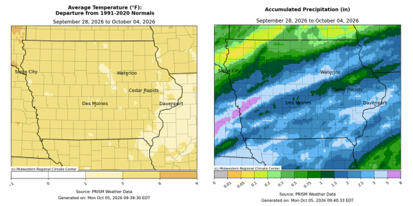
After a very wet start to the reporting period influenced by moisture from the remnants of Hurricane Polo, a major pattern shift finally brought drier weather to Iowa. Temperatures also rebounded to above normal with positive departures approaching six degrees; the statewide average temperature was 61.8 degrees, 4.0 degrees above normal.
Showers lingered across eastern Iowa into Sunday (27th) afternoon with overcast skies statewide and temperatures rising into the evening hours; upper 70s were observed in southwest Iowa with upper 60s southeast and upper 50s northeast. Foggy conditions developed around sunrise on Monday (28th) under persisting cloud cover and morning lows in the low 60s. Clear skies in the southeast corner helped temperatures drop into the mid 50s with a light northerly wind. Sunshine returned to much of southern Iowa through the day with highs reaching into the mid to upper 70s; cloud cover farther north held temperatures in the 60s. Southeasterly winds developed overnight into Tuesday (29th) under starry skies with temperatures in the mid to upper 50s east to low 60s west. Clouds increased through the day as showers pushed into western Iowa by the late afternoon hours. Rainfall overspread the state into the morning hours on Wednesday (30th) with widespread fog, light southerly winds and temperatures in the 60s. Much of southern Iowa received between 0.50 to 1.50 inches with higher totals southwest to south-central; several stations reported more than 2.00 inches with 2.07 inches in Creston (Union County) to 2.40 inches in Indianola (Warren County) and a statewide average of 0.70 inch. A more potent low pressure center advancing through Nebraska brought initial lines of moderate to heavy rainfall to western Iowa by midnight, necessitating flash flood warnings. Higher rainfall rates spread across west-central to north-central Iowa, with a swath of more than a month’s worth of rainfall along the surface warm front; Logan (Harrison County) reported 4.68 inches, Earling (Shelby County) hit 4.93 inches with 5.51 inches in Portsmouth (Harrison County). Widespread 2.00-4.00 inch totals at over 60 stations extended northeast and along the periphery of the high-intensity swath; 178 stations collected at least an inch with a statewide average of 1.18 inches.
The system and its attendant cold front continued into eastern Iowa through Thursday (1st) with clearing skies and a shift to northerly winds in western Iowa. Rainfall was generally over by sunrise on Friday (2nd) with morning lows in the mid to upper 40s in northwestern Iowa, behind the surface boundary. Rain totals were highest in the southeast corner with a handful of stations over 2.00 inches; Le Claire Lock and Dam (Scott County) registered 2.01 inches with 2.62 inches in Wapello (Louisa County) and 4.15 inches in Muscatine (Muscatine County). Air temperatures warmed into the low 60s with light and variable winds, beginning a string of pleasant days not seen since early September. Morning lows on Saturday (3rd) were in the mid to upper 40s with pockets of low 50s. Ample sunshine and gusty southerly winds pushed temperatures back into the 60s with low dewpoints, promoting evaporation of shallow soil moisture. Star lit skies persisted into Sunday (4th) with morning temperatures in the 50s.
Weekly precipitation totals ranged from 0.06 inch in Sheldon (O’Brien County) to 6.49 inches in Portsmouth. The statewide weekly average precipitation was 1.99 inches, while the normal is 0.74 inch. Mount Pleasant (Henry County) reported the week’s high temperature of 84 degrees on the 29th, 12 degrees above normal. Spencer Municipal Airport (Clay County) reported the week’s low temperature of 34 degrees from the 2nd, 10 degrees below normal.