Iowa Crop Progress and Condition Report
April 13-19, 2026
DES MOINES, Iowa (April 20, 2026) - Iowa Secretary of Agriculture Mike Naig commented on the Iowa Crop Progress and Condition Report released by the USDA National Agricultural Statistics Service. The report is released weekly April through November. Additionally, the Iowa Department of Agriculture and Land Stewardship provides a weather summary each week during this time.
“Last week’s active weather pattern presented plenty of severe weather challenges across the state. Farmers certainly welcomed the moisture, but we could have gone without the wind, hail and tornadoes,” said Secretary Naig. “This week looks to be a bit quieter, and that will help farmers as they look to get the planters rolling.”
Crop Report
There were 2.7 days suitable for fieldwork during the week, 2.8 days less than last year. Topsoil moisture condition rated 2 percent very short, 8 percent short, 72 percent adequate and 18 percent surplus. Corn planting in Iowa reached 2 percent complete, which is 14 percentage points behind last year when 16 percent had been planted. Soybean planting reached 1 percent, which is 9 percentage points behind 2025 when 10 percent of the crop had been planted. Oats seeding reached 51 percent complete, 14 percentage points behind last year.
The weekly report is also available on the USDA’s website at https://www.nass.usda.gov/.
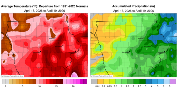
Weather Summary
Provided by Justin Glisan, Ph.D., State Climatologist, Iowa Department of Agriculture and Land Stewardship
Severe weather was the headline through the reporting period with several rounds of thunderstorms producing all modes of hazardous weather, including large hail, flash flooding and several tornadoes. This was also the third consecutive week of above-normal rainfall for much of Iowa. Temperatures were well above average with positive departures approaching 14 degrees from central to southeast Iowa; the statewide average temperature was 60.3 degrees, 11.4 degrees above normal.
Showers streamed across Iowa’s eastern half through Sunday (12th) afternoon while sunny skies and gusty southerly winds held over northwestern Iowa. Rainfall was highest along a narrow south-central to northeast band with 0.69 inch at Rathbun Dam (Appanoose County) to 0.95 inch in Peosta (Dubuque County); general totals where rain fell were in the 0.20- to 0.40-inch range. The first of four severe weather days occurred across northern Iowa on Monday (13th) as a low pressure center transited the Iowa-Minnesota border. Afternoon temperatures pushed into the upper 70s in the presence of ample low-level moisture and wind shear. A few weak tornadoes developed later in the evening along with pockets of large hail and locally heavy rainfall; Ringsted (Emmet County) registered 0.97 inch while Lake Mills (Winnebago County) collected 1.42 inches. Tuesday (14th) dawned unseasonably warm in southern and eastern Iowa where morning air temperatures and dewpoints were in the low to mid 60s. A secondary low pressure center pushed through central Iowa as the attendant cold front clashed with warm, unstable air to the east, firing strong to severe thunderstorms. The storms raced east into the evening hours, producing two EF-1 tornadoes in Masonville (Buchanan County) and Dubuque (Dubuque County). Large hail was also widespread in eastern Iowa with a 3.5-inch hailstorm reported in Elma (Howard County). Stronger storms training over the same locations also produced very heavy rainfall; six stations hit 2.00 inches or more with 2.45 inches in Hartford (Warren County) and 2.78 inches in Sully (Jasper County). Much of Iowa’s southeastern two-thirds reported totals of a few tenths of an inch with a statewide average of 0.51 inch.
Severe weather on Wednesday (15th) was dominated by large hail across much of southern Iowa along with isolated straight-line wind reports in the southeast corner. Significant rainfall occurred at more than 30 stations where at least 1.00 inch was observed. Many locations in eastern Iowa picked up more than 0.75 inch with multiple tenths of inch farther west. The statewide average rainfall was 0.55 inch with the highest total of 1.93 inches in Vinton (Benton County). Thursday (16th) was a pleasant day with morning lows in the upper 40s and low 50s under clear skies with a light westerly wind. Winds turned southerly into the afternoon hours, boosting highs into the upper 70s southeast to mid 80s northwest. Clouds increased overnight into Friday (17th) as a strong low pressure center pushed into northwest Iowa. A cold front rapidly moved through western Iowa as instability, wind shear and moisture ramped up from central to eastern Iowa. Initial discrete supercells fired in eastern Iowa, well ahead of the surface boundary. Frontal-based thunderstorms were able to overcome the low-level cap and rapidly intensify just east of Des Moines (Polk County). Thunderstorms merged along the front as several became severe and tornado warned. Washington (Washington County) reported structural damage to farm buildings from a tornado. Straight-line winds became the dominate severe weather mode as the front moved closer to the Mississippi River; Cascade (Dubuque County) measured an 86 mph wind gust. Moderate to heavy rainfall was widespread in eastern Iowa with 1.02 inches in Ottumwa (Wapello County) and 2.35 inches in Wayne County. Saturday (18th) into Sunday (19th) was much less active with partly cloudy skies and much cooler temperatures.
Weekly precipitation totals ranged from no accumulation in Rock Rapids (Lyon County) to 4.34 inches at Bellevue Lock and Dam (Jackson County). The statewide weekly average precipitation was 1.27 inches; the normal is 0.87 inch. Lamoni (Decatur County) reported the week’s high temperature of 89 degrees on the 15th, 26 degrees above normal. Lake Park (Dickinson County) reported the week’s low temperature of 23 degrees on the 18th, 12 degrees below normal. Four-inch soil temperatures varied from the upper 40s north to mid 50s south as of Sunday.