Iowa Crop Progress and Condition Report
Sept. 14-20, 2026
DES MOINES, Iowa (Sept. 21, 2026) - Iowa Secretary of Agriculture Mike Naig commented on the Iowa Crop Progress and Condition Report released by the USDA National Agricultural Statistics Service. The report is released weekly April through November. Additionally, the Iowa Department of Agriculture and Land Stewardship provides a weather summary each week during this time.
“An extremely soggy week across much of Iowa made it difficult for farmers to get much fieldwork done, with heavy rainfall leading to flooding in some areas,” said Secretary Naig. “We’re hopeful for a few dry days ahead, but more rain is in the forecast. Conditions are good for flying on cover crops, and the moisture can help get them germinated and growing. When fields finally firm up, Iowa farmers will get combines rolling and harvest will be fully underway.”
Crop Report
There were 1.7 days suitable for fieldwork during the week ending Sept. 20, 2026. This 3.2 days less than last year, when there were 4.9 days suitable for fieldwork. Topsoil moisture condition rated 4 percent short, 68 percent adequate, and 28 percent surplus. Subsoil moisture condition rated 2 percent very short, 11 percent short, 69 percent adequate, and 18 percent surplus. Nine-five percent of corn reached the dent stage, which is 1 percentage point ahead of last year. Fifty-six percent of corn has reached maturity, which is 7 percentage points behind last year. Four percent of corn has been harvested, which is 3 percentage points behind last year. Corn condition rated 76 percent good to excellent. Forty-six percent of soybeans are dropping leaves, which is 12 percentage points behind last year. Two percent of soybeans have been harvested, which is 2 percentage points behind last year. Soybean condition rated 75 percent good to excellent. Pasture condition rated 70 percent good to excellent.
The weekly report is also available on the USDA’s website at https://www.nass.usda.gov/.
Weather Summary
Provided by Justin Glisan, Ph.D., State Climatologist, Iowa Department of Agriculture and Land Stewardship
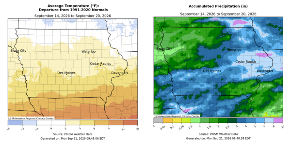
As if the recent anomalous wetness was not enough, Iowans experienced a week in which the preliminary statewide average rainfall was higher than the 30-year climatological normal for all of September. The wettest conditions were found across a broad swath from southwest to eastern Iowa, where totals were 4.00 to 8.00 inches above normal. Temperatures moderated somewhat with near-normal to slightly cooler conditions north to positive departures approaching ten degrees south; the statewide average temperature was 66.1 degrees, 2.7 degrees above normal.
A persistent high pressure dome above the southern United States continued to act as a focusing mechanism for several rounds of showers and thunderstorms that brought moderate to heavy sustained rainfall to many stations. Ample moisture transport from the Gulf along with mid-level Pacific monsoonal moisture streaming in from the southwest provided exceedingly high precipitable water content in the atmosphere over Iowa; this is basically a depth measurement of liquid water over a given location if all water vapor was precipitated out. While rainfall was reported somewhere in the state on every day of the week, two events at the beginning and end of the reporting period stand out for the amount and intensity of rainfall. The first event spanned Sunday (13th) through Tuesday (15th) from western Iowa into the central and eastern parts of the state. Surface boundaries situated just north of the existing ridge focused showers and thunderstorms with many stations across the state’s southern half collecting at least 2.00 inches. A narrower swath from Council Bluffs (Pottawattamie County) to Des Moines (Polk County) registered amounts in the 3.00 to 5.00-inch range with pockets of 5.00 to 8.00 inches in west-central Iowa; more than 50 stations had at least 3.00 inches with a majority of the state receiving at least 1.00 inch. Two Atlantic (Cass County) stations reported 5.08 and 6.06 inches with 6.31 inches in Oakland (Pottawattamie County). On Monday (14th) a broad Tornado Watch was issued for the southwest corner of the state as windshear profiles and instability were supportive of tornadogenesis; however, lack of daytime heating removed the tornadic threat as a line of severe thunderstorms moved into central Iowa. Polk County became a bullseye for very heavy rainfall from training storms with numerous stations around Des Moines receiving multiple inches over just a few hours, from 2.81 inches in Urbandale to 3.45 inches in Clive and 3.83 inches in Johnston. The statewide average rainfall through this period was 1.69 inches.
The second notable event concentrated on eastern Iowa over a general span of time from just after midnight on Friday (18th) into Sunday (20th) morning. An upper-level disturbance in conjunction with a surface low pressure center riding the ridge brought sustained rainfall from Muscatine (Muscatine) and Davenport (Scott County) north to the state borders with southeastern Minnesota and southwestern Wisconsin. The first thrust of heavy rain was through the morning hours with redevelopment across southern Iowa as the low-level jet kicked in and pushed torrential rainfall from east-central to eastern Iowa. Flash flood warnings were issued over numerous counties after sustained rainfall late Saturday (19th) with major flooding reported along the Turkey River in Muscatine County. As rainfall dissipated, nearly 60 stations observed 4.00 inches or more; Ainsworth (Washington County) had exactly 5.00 inches from this round with 5.88 inches in Fayette (Fayette County) and 6.75 inches in North Liberty (Johnson County) with a statewide average of 1.70 inches.
Weekly precipitation totals ranged from 0.05 inch in Milford (Dickinson County) to 10.63 inches in Ainsworth. The statewide weekly average rainfall was 3.57 inches, more than four times the normal of 0.83 inch. Clarinda (Page County) reported the week’s high temperature of 97 degrees on the 18th, 20 degrees above normal. Several stations reported the week’s low temperature of 46 degrees from the 14th to 16th, on average four degrees below normal.