Iowa Crop Progress and Condition Report
Sept. 21-27, 2026
DES MOINES, Iowa (Sept. 28, 2026) - Iowa Secretary of Agriculture Mike Naig commented on the Iowa Crop Progress and Condition Report released by the USDA National Agricultural Statistics Service. The report is released weekly April through November. Additionally, the Iowa Department of Agriculture and Land Stewardship provides a weather summary each week during this time.
“Wet conditions persisted last week, with much of the state receiving above-average rainfall. This month is on track to go down as one of the warmest and wettest Septembers on record for the state of Iowa,” said Secretary Naig. “As we move into October, warm weather is expected to continue, and we may finally get a break from the rain. Farmers are eager to harvest their crops and will be ready to get combines rolling as soon as the fields dry out.”
Crop Report
There were 1.1 days suitable for fieldwork during the week ending Sept. 27, 2026. This is 5.1 days less than last year, when there were 6.2 days suitable for fieldwork. Topsoil moisture condition rated 2 percent short, 59 percent adequate, and 39 percent surplus. Subsoil moisture condition rated 1 percent very short, 8 percent short, 64 percent adequate, and 27 percent surplus. Ninety-seven percent of corn reached the dent stage, which is unchanged from last year. Seventy-two percent of corn has reached maturity, which is 6 percentage points behind last year. Five percent of corn has been harvested, which is 9 percentage points behind last year. Corn condition rated 75 percent good to excellent. Sixty-two percent of soybeans are dropping leaves, which is 18 percentage points behind last year. Three percent of soybeans have been harvested, which is 12 percentage points behind last year. Soybean condition rated 74 percent good to excellent. Pasture condition rated 70 percent good to excellent.
The weekly report is also available on the USDA’s website at https://www.nass.usda.gov/.
Weather Summary
Provided by Justin Glisan, Ph.D., State Climatologist, Iowa Department of Agriculture and Land Stewardship
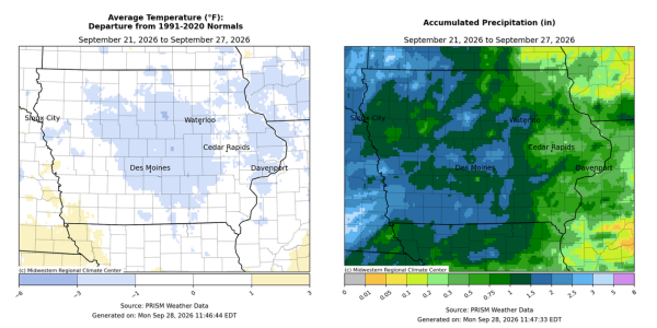
While rainfall was above normal across Iowa during the reporting period, it was not as unseasonably wet as the previous two weeks. Pockets of central and western Iowa experienced totals of 1.00-2.00 inches above average with the rest of the state near normal to slightly wetter. Temperatures were also unseasonably cold across most of Iowa with departures approaching three degrees; the statewide average temperature was 59.8 degrees, 0.9 degree below normal.
Overcast skies persisted through the rest of Sunday (20th) with stronger northeasterly winds and daytime highs in the 60s. Showers developed over northwest Iowa into the overnight hours of Monday (21st) and expanded into north-central to eastern Iowa through the daylight hours. A handful of stations reported more than an inch with 1.47 inches in Sibley (Osceola County) and 1.68 inches in Burt (Kossuth County). Additional development occurred in west-central Iowa. Winds became more easterly as light rain was observed with temperatures in the mid 50s northwest to low 60s southeast. Widespread rain totals reported on Tuesday (22nd) morning were between 0.50 and 1.00 inch in the northeast quadrant with 0.25 to 0.50 inch farther south and west. Low temperatures and daytime highs were not that far apart, with mid 50s early in the day to low 60s as clouds began to thin into the evening. Wednesday (23rd) dawned with southeasterly winds and mostly cloudy skies along the Iowa-Illinois border. The daylight hours were pleasant with highs in the low to mid 60s with a return of sunshine. Air temperatures gradually rose into the upper 60s just before midnight with low 70s reported southwest. Clouds increased over western Iowa by sunrise on Thursday (24th) as a broad shield of showers entered the state. The complex pushed east throughout the day, leading to widespread rain totals across the state. Showers continued over southern Iowa overnight and through much of Friday (25th) morning. Additional showers and some thunderstorms pushed into southwest Iowa, ahead of a slow-moving low pressure center over Kansas. High temperatures under overcast skies held in the 60s with southeasterly winds pushing in additional low-level moisture. Event rain totals for the previous 36 hours had most stations in western Iowa reporting at least 0.50 inch with 2.00-3.00 inches in the southwest corner. Over 70 stations registered at least an inch with 2.00 inches in Randolph (Fremont County), 2.46 inches in Pacific Junction (Mills County) and 2.73 inches in Missouri Valley (Harrison County); the statewide average total was 0.60 inch. Showers extending north to south and moving eastward brought continued rainfall to much of northern and eastern Iowa through Saturday (26th) afternoon. Broadscale totals were above 0.25 inch where rain fell with heavier totals in south-central and northeast Iowa. Daytime temperatures rose into the 60s with the help of persisting southeasterly winds. Several stations in Black Hawk County reported over an inch at 7:00 am on Sunday (27th), with 1.04 inches in Cedar Falls and 1.25 inches in Waterloo. Higher totals farther south included 1.11 inches in Allerton (Wayne County) to 1.44 inches in Lovilia (Monroe County).
Weekly precipitation totals ranged from 0.19 inch at Dubuque Regional Airport (Dubuque County) to 3.61 inches at Eagle Grove (Wright County). The statewide weekly average rainfall was 1.26 inches, while the normal is 0.80 inch. Ames (Story County) and Lowden (Cedar County) reported the week’s high temperature of 75 degrees on the 23rd, on average one degree above normal. Mason City Municipal Airport (Cerro Gordo County) reported the week’s low temperature of 42 degrees from the 23rd, four degrees below normal.