Iowa Crop Progress and Condition Report
Aug. 31 – Sept. 6, 2026
DES MOINES, Iowa (Sept. 8, 2026) — Iowa Secretary of Agriculture Mike Naig commented on the Iowa Crop Progress and Condition Report released by the USDA National Agricultural Statistics Service. The report is released weekly April through November. Additionally, the Iowa Department of Agriculture and Land Stewardship provides a weather summary each week during this time.
“The first week of September was one of the hottest on record, setting up some muggy conditions for attendees at the Farm Progress Show. As we headed into the Labor Day weekend, parts of northern Iowa received much-needed rainfall that will help chip away at longer-term soil moisture deficits,” said Secretary Naig. “Farmers are busy chopping silage and preparing for harvest as we wait for corn and soybeans to dry down and fully mature. We’re keeping an eye on the outlooks, which show more seasonal temperatures and better chances of rainfall as we move into mid-September.”
Crop Report
There were 5.6 days suitable for fieldwork during the week ending Sept. 6, 2026. This is 0.4 days less than last year, when there were 6.0 days suitable for fieldwork. Topsoil moisture condition rated 3 percent very short, 23 percent short, 70 percent adequate, and 4 percent surplus. Subsoil moisture condition rated 5 percent very short, 24 percent short, 68 percent adequate, and 3 percent surplus. Ninety-six percent of Iowa’s corn crop has reached the dough stage, which is unchanged from last year. Seventy-nine percent of corn reached the dent stage, which is 1 percentage point ahead of last year. Seventeen percent of corn has reached maturity, which is 7 percentage points behind last year. Corn condition rated 77 percent good to excellent. Six percent of soybeans are dropping leaves, which is 4 percentage points behind last year. Soybean condition rated 75 percent good to excellent. Oat harvest has largely concluded, which is slightly ahead of last year. Pasture condition rated 64 percent good to excellent.
The weekly report is also available on the USDA’s website at https://www.nass.usda.gov/.
Weather Summary
Provided by Justin Glisan, Ph.D., State Climatologist, Iowa Department of Agriculture and Land Stewardship
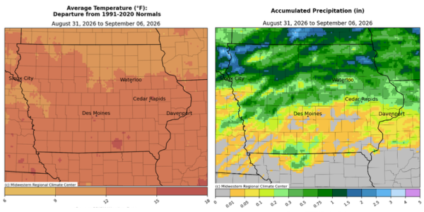
The weather headline for the reporting period was unseasonably hot temperatures, producing one of the warmest starts to September on record. Conditions across Iowa’s southern half were 12 to 15 degrees above normal with slightly cooler conditions north due to more cloud cover and rainfall. The statewide average temperature was 79.8 degrees, 11.1 degrees above normal.
Showers and a few thunderstorms continued across eastern Iowa into Sunday (30th) afternoon. There was a broad range of afternoon temperatures, from the low 90s southwest to upper 70s northeast. Rain totals were generally between 0.25 to 0.50 inch with pockets of higher totals in the northeast; McGregor (Clayton County) observed 0.50 inch with 0.58 inch in Marion (Linn County). Winds shifted southwesterly overnight into Monday (31st) with morning lows in the upper 60s to mid 70s north to south. A few scattered showers moved through Iowa during the late morning hours, though totals were light and isolated. Daytime conditions were mostly sunny with mid to upper 80s over northern Iowa and low to mid 90s across the southern part of Iowa. Overnight lows bottomed out in the upper 60s and low 70s with areas of fog due to light winds, clear skies and high dewpoints. Afternoon conditions on Tuesday (1st) were similar to the previous day with winds turning easterly across western Iowa as a strong disturbance rode a strong ridge that was in place over the southern United States. Strong thunderstorms pushed into northwestern Iowa after sunset, with some cells becoming severe and tornado-warned; no tornadoes were observed but there were several strong wind gusts with a 81-mph reading in Hawarden (Sioux County) and 87-mph gust in Britt (Hancock County). Northwest stations collected the highest amounts with 1.00 inch in Orange City (Sioux County), 1.72 inches in Rock Rapids (Lyon County), and 2.00 inches in Le Mars (Plymouth County). Thunderstorms continued from north-central into eastern Iowa through much of Wednesday (2nd) with daytime temperatures from the mid 80s north to upper 90s south. Northern Iowa received the most rain with 0.80 inch in Lake Mills (Winnebago County) to a 1.12-inch report in Lake Park (Dickinson County).
Scattered thunderstorms developed into Thursday (3rd) from southwest to northeast Iowa with morning lows in the 70s and southerly winds. Rainfall dissipated by the late afternoon hours with general totals under a few tenths of an inch with higher totals in west-central Iowa; Schleswig (Crawford County) recorded 0.65 inch while 1.10 inches was observed in Sac City (Sac County). Clouds held from central to northeast Iowa through Friday (4th) with isolated thunderstorms firing later in the day. Some of the storms were severe-warned along the Iowa-Wisconsin border where large hail and gusty winds were observed. Two stations in Allamakee County, Monona and Postville, observed 1.03 and 1.14 inches of rainfall, respectively. A complex of thunderstorms fired along an existing outflow boundary and moved into northwest Iowa before sunrise on Saturday (5th). Several stations reported more than 1.00 inch of rainfall before the disturbance dissipated; Rock Rapids (Lyon County) had 1.60 inches with 1.88 inches in Massena (Cass County). Daytime conditions were quiet with upper 70s north to low 90s south under easterly winds. Compared to the last several mornings, Sunday (6th) dawned with cooler temperatures, in the mid to upper 60s east, with mostly cloudy skies and widespread fog.
Weekly precipitation totals ranged from no measurable amounts at multiple southern stations to 3.05 inches in Sioux Center (Sioux County). The statewide weekly average rainfall was 0.37 inch, while the normal is 0.88 inch. Donnelson (Lee County) and Lamoni (Decatur County) reported the week’s high temperature of 100 degrees on the 1st and 3rd, respectively, on average eight degrees above normal. Lake Park reported the week’s low temperature of 47 degrees on the 24th, 12 degrees below normal.