Iowa Crop Progress and Condition Report
Aug. 3-9, 2026
DES MOINES, Iowa (Aug. 10, 2026) - Iowa Secretary of Agriculture Mike Naig commented on the Iowa Crop Progress and Condition Report released by the USDA National Agricultural Statistics Service. The report is released weekly April through November. Additionally, the Iowa Department of Agriculture and Land Stewardship provides a weather summary each week during this time.
“Widespread rain during the week and storms over the weekend brought welcome moisture to many parts of Iowa. Unfortunately, western and northwestern portions of the state did not receive enough rain to improve drought conditions. Severe thunderstorms also left behind tornado, wind, and hail damage for some communities and farms in eastern Iowa,” said Secretary Naig. “As excitement builds for the opening day of the Iowa State Fair, cooler temperatures and additional chances for showers will stick around for the first few days, while the forecast for the next week shows better chances of significant rainfall totals.”
Crop Report
There were 5.1 days suitable for fieldwork during the week ending Aug. 9, 2026. This is .4 days more than last year, when there were 4.7 days suitable for fieldwork. Topsoil moisture condition rated 7 percent very short, 21 percent short, 67 percent adequate, and 5 percent surplus. Subsoil moisture condition rated 7 percent very short, 27 percent short, 62 percent adequate, and 4 percent surplus. Corn silking reached 97 percent, which is 2 percentage points ahead of last year. Sixty-nine percent of Iowa’s corn crop has reached the dough stage, which is 3 percentage points ahead of last year. Twelve percent of corn reached the dent stage, which is 2 percentage points behind last year. Corn condition rated 78 percent good to excellent. Soybeans blooming reached 93 percent, which is 1 percentage point ahead of last year. Seventy-two percent of soybeans were setting pods, which is 2 percentage points behind last year. Soybean condition rated 77 good to excellent. Ninety-three percent of oats have been harvested, which is 13 percentage points ahead of last year. Oats condition rated 82 percent good to excellent. Pasture condition rated 66 percent good to excellent.
The weekly report is also available on the USDA’s website at https://www.nass.usda.gov/.
Weather Summary
Provided by Justin Glisan, Ph.D., State Climatologist, Iowa Department of Agriculture and Land Stewardship
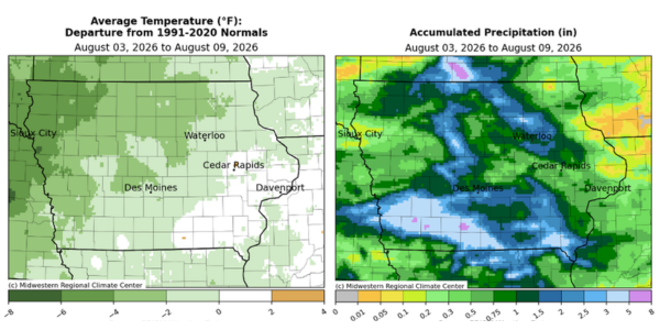
Several rounds of showers and thunderstorms brought well-above normal rainfall across portions of the state. All modes of severe weather were also reported, particularly in eastern Iowa. Cloud cover, rainfall and wildfire smoke held temperatures below to near-normal from west to east across Iowa; the statewide average temperature was 74.5 degrees, 0.4 degrees above normal.
Variable winds and mostly sunny skies prevailed through Sunday (2nd) afternoon with highs in the lower 80s. Winds turned southerly into Monday (3rd) morning with dense fog over portions of southern Iowa with lows in the 60s. Southerly winds increased throughout the day as a cold front approached from the west. Daytime temperatures held in the low 80s with passing clouds and some haze. Showers and a few thunderstorms moved into western Iowa after midnight and continued across the state through Tuesday (4th). The front slowed as a low pressure center over Missouri intensified, shifting more moisture into southwestern Iowa. After midnight, two areas of moderate rainfall were found in the southeast corner along with more development farther west; this complex intensified as embedded thunderstorms became severe-warned with large hail and strong wind gusts. Under cloud cover and rainfall, morning lows on Wednesday (5th) held in the mid to upper 60s with upper 50s over northern Iowa. Thunderstorms continued from central Iowa into the southeastern reaches of the state until the system fully exited by Wednesday (5th) afternoon. Continuous rainfall over southern Iowa led to some flash flood warnings along with more than a month’s worth of rainfall; Seymour (Wayne County) collected 4.26 inches with 4.63 inches in Creston (Union County) and 5.72 inches in Murray (Clarke County). Over 150 stations observed at least 1.00 inch with more than 50 receiving at least double that amount and a statewide average of 0.96 inch. Light easterly winds developed overnight into Thursday (6th) with widespread fog and temperatures from the low 50s northwest to upper 60s south east. Afternoon conditions were partly cloudy with pleasant temperatures in the mid to upper 70s and light southerly winds.
Friday (7th) was an active severe weather day across the state with widespread fog and heavy dew starting the day as temperatures held in the mid to upper 60s. Ample low-level moisture and atmospheric instability ahead of a strong cold front were ideal ingredients for a complex of severe thunderstorms from north-central through eastern Iowa. The most significant event was a longer track EF-2 tornado near Fairbanks (Buchanan County) along with an EF-1 in Prairieburg (Linn County). The remains of the complex lost energy and pushed out of southeast Iowa just before midnight. Rainfall totals reported at 7:00 am on Saturday (8th) were highest from east-central to northeast Iowa; Mason City (Cerro Gordo County) observed 2.21 inches while Nashua (Floyd County) hit 2.24 inches. There were also a swath of stations into southeastern Iowa that had widespread totals from 0.75 to 1.00 inch. A warm front pushing north into Iowa was a focusing mechanism for additional thunderstorm development into Sunday (9th) morning. A slow moving cell brought heavier downpours over Fort Dodge (Webster County) where four stations reported between 2.00 and 2.38 inches. A broad swath from north-central into southwest Iowa also received general totals in the 0.75-1.50 inch range. Morning temperatures were in the upper 60s northeast to upper 70s southwest.
Weekly rain totals ranged from 0.04 inch near Dubuque (Dubuque County) to 5.77 inches in Murray (Clarke County). The statewide weekly average rainfall was 1.87 inch; the normal is 0.88 inch. Des Moines International Airport (Polk County) reported the week’s high temperature of 91 degrees on the 9th, seven degrees above normal. Spencer Municipal Airport (Clay County) reported the week’s low temperature of 47 degrees on the 8th, 14 degrees below normal.