Iowa Crop Progress and Condition Report
Aug. 4 – 10, 2025
DES MOINES, Iowa (Aug. 11, 2025) — Iowa Secretary of Agriculture Mike Naig commented on the Iowa Crop Progress and Condition Report released by the USDA National Agricultural Statistics Service. The report is released weekly April through November. Additionally, the Iowa Department of Agriculture and Land Stewardship provides a weather summary each week during this time.
“After a soggy and muggy start to the Iowa State Fair, temperatures and humidity eased, making for a more pleasant first Sunday of the event. Unfortunately, there are parts of the state, especially in eastern Iowa, that are also dealing with localized flooding from several waves of heavy rainfall,” said Secretary Naig. “Looking ahead, forecasts are indicating seasonal temperatures and drier conditions for the final week of the fair.”
The weekly report is also available on the USDA’s website at nass.usda.gov.
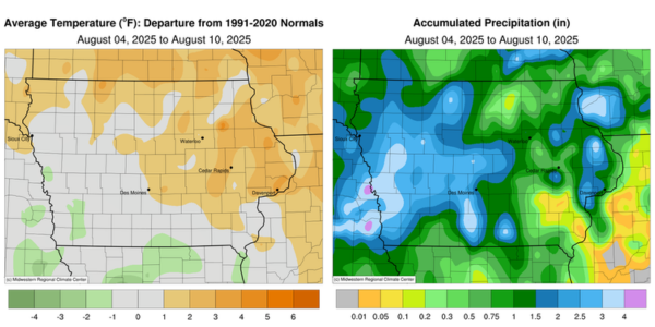
Crop Report
Precipitation, heaviest in the western third of the State, limited producers to 4.7 days suitable for fieldwork during the week ending August 10, 2025, according to the USDA, National Agricultural Statistics Service. Some fields started to dry out while low spots still had ponding. Field activities included harvesting oats and hay as conditions allowed.
Topsoil moisture condition rated 0 percent very short, 2 percent short, 68 percent adequate and 30 percent surplus. Subsoil moisture condition rated 0 percent very short, 3 percent short, 71 percent adequate and 26 percent surplus.
Ninety-six percent of Iowa’s corn has reached the silking stage. Corn in the dough stage was 68 percent, 1 day ahead of both last year’s pace and the 5-year average. Fifteen percent of the corn crop was dented. Corn condition rated 1 percent very poor, 2 percent poor, 11 percent fair, 57 percent good and 29 percent excellent. Soybeans blooming reached 93 percent. Seventy-five percent of soybeans were setting pods, 2 days ahead of last year, but 3 days behind normal. Soybean condition rated 1 percent very poor, 2 percent poor, 16 percent fair, 60 percent good and 21 percent excellent. Eighty-three percent of the oat crop has been harvested for grain, 1 week behind last year and 5 days behind average.
The second cutting of alfalfa hay neared completion while 50 percent of the third cutting has been completed. Hay condition rated 85 percent good to excellent.
Weather Summary
Provided by Justin Glisan, Ph.D., State Climatologist, Iowa Department of Agriculture and Land Stewardship
August’s first full week was unseasonably wet across western Iowa with drier conditions southeast; a wet reporting period along with the 2nd wettest July on record aided in the removal of all remaining drought from Iowa. Weekly temperatures varied from above to near average northeast to southwest, respectively, with a statewide average of 73.9 degrees, 1.8 degrees above normal.
Sunday (3rd) afternoon temperatures were pleasant, holding in the low to mid 70s with mostly sunny skies and southeasterly winds. The flow shifted easterly into early Monday (4th) with some patchy fog reported at east-central stations and morning temperatures in the low to mid 60s. Scattered showers in western Iowa brought some stations a few tenths of an inch with Mondamin (Harrison County) collecting 0.44 inch. Daytime conditions remained partly cloudy with temperatures warming into the upper 70s with some lingering Canadian wildfire smoke. Overnight lows dipped into the upper 50s and low 60s with easterly winds persisting at sunrise on Tuesday (5th). High temperatures into the afternoon hours rose into the upper 70s and low 80s as southerly winds shifted in advance of a complex of thunderstorms moving through South Dakota and Minnesota. The line entered northern Iowa after midnight on Wednesday (6th) and continued south before dissipating in south-central Iowa during the late morning. Northwestern Iowa stations reported widespread one-inch totals with 2.00 inches in Lake Park (Dickinson County) and 2.20 inches at Odebolt (Sac County). Skies remained mostly sunny through the daylight hours with temperatures returning to the upper 70s to mid 80s. Overnight lows into Thursday (7th) held in the upper 60s to low 70s as sluggish thunderstorms formed over south-central Iowa, bringing rainfall to the opening ceremony of the 166th Iowa State Fair in Des Moines (Polk County). Nearly 15 stations observed totals over two inches with 2.04 inches in Earlham (Madison County), 3.22 inches at Williamson (Lucas County) and 4.01 inches in Osceola (Clarke County); totals farther north and west were in the 0.50- to 1.00-inch range.
Afternoon conditions stabilized with a persisting southerly wind and cloud cover in western and northern Iowa. Friday (8th) dawned warm and muggy with temperatures in the low 70s and clear skies. Daytime conditions quickly warmed into the upper 80s and low 90s with dewpoints in the mid to upper 70s. Ample atmospheric moisture and instability helped fire stronger thunderstorms across northwestern Iowa towards the nighttime hours in advance of a strong cold front. Several cells became severe warned with strong gusts in the 60-70 mph range in west-central Iowa. Flash flooding also occurred due to slow-moving thunderstorms producing heavy rain. The line lost strength as it advanced into central and eastern Iowa through Saturday (9th) morning and early afternoon. After a quiet late afternoon and evening, strong thunderstorms redeveloped into Sunday (10th) morning ahead of a low pressure system over southwest Iowa, spreading across the state. Thirty-six-hour rain totals showed nearly 50 stations in pockets of western, central and eastern Iowa registering at least 2.00 inches with the heaviest totals from 3.23 inches in Muscatine (Muscatine County) to 4.77 inches in Pacific Junction (Mills County). More than 130 stations observed at least one inch with a statewide average of 0.86 inch. Morning temperatures in southeast Iowa were in the mid to upper 70s at some stations.
Weekly precipitation totals ranged from 0.01 inch at Ainsworth (Washington County) to 6.64 inches in Pacific Junction. The statewide weekly average precipitation was 1.60 inches; the normal is 1.01 inches. Several stations reported the week’s high temperature of 93 degrees on the 8th, on average nine degrees above normal. Elkader (Clayton County) reported the week’s low temperature of 52 degrees on the 6th, seven degrees below normal.