Iowa Crop Progress and Condition Report
Aug. 18-24, 2025
DES MOINES, Iowa (Aug. 25, 2025) – Iowa Secretary of Agriculture Mike Naig commented on the Iowa Crop Progress and Condition Report released by the USDA National Agricultural Statistics Service. The report is released weekly April through November. Additionally, the Iowa Department of Agriculture and Land Stewardship provides a weather summary each week during this time.
“Farmers across Iowa enjoyed a welcome break from the rain last week along with cooler temperatures and less humidity,” said Secretary Naig. “As we finish out August, the forecast calls for more of the same this week. Looking ahead, initial outlooks are pointing toward a potentially warmer September as harvest approaches.”
The weekly report is also available on the USDA’s website at nass.usda.gov.
Crop Report
Iowa had 5.6 days suitable for fieldwork during the week ending August 24, 2025, according to the USDA, National Agricultural Statistics Service. The week started with warm temperatures but closed with much cooler weekend weather. Field activities included harvesting oats and hay. Reports noted increasing levels of disease in field crops.
Topsoil moisture condition rated 1 percent very short, 5 percent short, 74 percent adequate and 20 percent surplus. Subsoil moisture condition rated 1 percent very short, 5 percent short, 77 percent adequate and 17 percent surplus.
Corn in the dough stage reached 88 percent, 1 day behind last year’s pace and 3 days behind normal. Corn in the dent stage reached 45 percent, 1 day ahead of last year, but 1 day behind the five-year average. Corn condition rated 1 percent very poor, 2 percent poor, 13 percent fair, 56 percent good and 28 percent excellent. Ninety percent of soybeans were setting pods, 1 day ahead of last year, but 4 days behind normal. Soybeans coloring reached 8 percent. Soybean condition rated 1 percent very poor, 3 percent poor, 17 percent fair, 59 percent good and 20 percent excellent. At 97 percent, almost all Iowa’s oat for grain crop has been harvested.
The third cutting of alfalfa hay reached 78 percent complete. Pasture condition rated 80 percent good to excellent.
Weather Summary
Provided by Justin Glisan, Ph.D., State Climatologist, Iowa Department of Agriculture and Land Stewardship
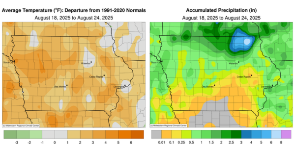
Early-week rainfall gave way to quieter conditions toward the weekend, with unseasonably high totals at several northeastern Iowa stations. Temperatures remained unseasonably warm for most of the reporting period, though a late-week cold front ushered in cooler and less humid air; the statewide average temperature was 73.0 degrees, 1.3 degrees above normal.
Sunday (17th) afternoon was hot and muggy across southern Iowa, where temperatures rose into the low 90s under sunny skies. Farther north, a stationary front was situated near the Iowa-Minnesota border, with highs in the mid- to upper 80s. This boundary was the forcing mechanism for slow-moving thunderstorms into the evening hours, one of which became severe and produced a weak tornado near Crystal Lake (Winnebago County). A broader complex of showers and thunderstorms formed in northwestern Iowa into Monday (18th) morning and pushed through the state before exiting northeastern Iowa after noon. Flash flood warnings were issued for northeastern counties due to heavy rain. Several stations from north-central to northeast Iowa reported significant rainfall, including 4.15 inches in Fort Atkinson (Winneshiek County), 6.51 inches in Elma (Howard County), and 8.64 inches in Decorah (Winneshiek County), which was the week’s highest amount. Nearly 35 stations recorded totals in the 2.00-to-4.00-inch range, with numerous 1.00-inch amounts in western and northern Iowa. Winds turned to a westerly direction into the afternoon as highs held in the low 80s north to the low 90s south. Clouds remained over northern Iowa through sunrise on Tuesday (19th), with widespread fog and temperatures in the mid 60s to low 70s. Daytime conditions were mostly sunny with light northerly winds and highs in the mid 80s statewide. Wednesday (20th) dawned with partly cloudy conditions, patchy fog and morning temperatures in the mid to upper 60s. Afternoon temperatures warmed by 10–20 degrees, with spotty showers reported southeast; a handful of stations observed a few tenths of an inch, including 0.35 inch at Bellevue Lock and Dam (Jackson County) and 0.43 inch in Wapello (Louisa County). Winds shifted to the east later in the night as starry skies appeared in the cloudless sky.
Thursday (21st) began a stretch of pleasant days as high pressure dominated the Upper Midwest. Daytime temperatures peaked in the upper 70s and low 80s, with a gradually shifting southwesterly wind into the evening hours. Overnight lows became more seasonal - in the upper 50s and low 60s - as clouds dotted portions of Iowa and fog developed at sunrise on Friday (22nd). Winds began shifting to the northwest through the late afternoon as a cold front dropped southeast through the state. Highs remained in the low 70s in northwest Iowa as the front passed, with upper 70s and low 80s elsewhere. Showers and a few thunderstorms formed along the surface boundary through the nighttime hours, with the front fully exiting the state by daybreak on Saturday (23rd). Rainfall was widespread, though very light, with most stations receiving less than 0.20 inch. Sioux City (Woodbury County) reported 1.05 inches from a thunderstorm, while two stations in Dallas Center (Dallas County) measured 0.75 to 0.81 inch from an overnight thundershower. The rest of the day was clear and breezy, with mostly sunny skies and highs in the 70s. The remaining clouds cleared by Sunday (24th) morning, which began chilly with lows in the upper 40s and low 50s.
The lowest reported weekly precipitation total was no accumulation at stations in south-central Iowa. The statewide weekly average precipitation was 0.87 inch, compared with a normal of 0.93 inch. Ames (Story County) reported the week’s highest temperature of 97 degrees on the 17th, 16 degrees above normal. Spencer Municipal Airport (Clay County) recorded the week’s lowest temperature of 45 degrees on the 24th, 13 degrees below normal.
