Iowa Crop Progress and Condition Report
July 7 – July 13, 2025
DES MOINES, Iowa (July 14, 2025) – Iowa Secretary of Agriculture Mike Naig commented on the Iowa Crop Progress and Condition Report released by the USDA National Agricultural Statistics Service. The report is released weekly April through November. Additionally, the Iowa Department of Agriculture and Land Stewardship provides a weather summary each week during this time.
“Iowans experienced another wild weather week with reports of weak tornadoes, hail and wind, along with pockets of significant rainfall producing flash flooding,” said Secretary Naig. “Though the rainfall is improving drought conditions and helping the corn during tasseling and pollination, there are now parts of the state that could use a break from the rain.”
The weekly report is also available on the USDA’s website at nass.usda.gov.
Crop Report
Rain on and off throughout the week limited farmers to 3.8 days suitable for fieldwork during the week ending July 13, 2025, according to the USDA, National Agricultural Statistics Service. Wet conditions made field activities difficult.
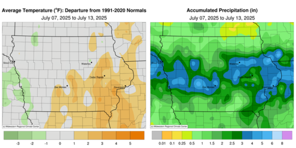
Topsoil moisture condition rated 0 percent very short, 6 percent short, 71 percent adequate and 23 percent surplus. Subsoil moisture condition rated 1 percent very short, 9 percent short, 74 percent adequate and 16 percent surplus.
Corn silking reached 36 percent, 1 day behind last year, but 1 day ahead of normal. Five percent of Iowa’s corn reached the dough stage. Corn condition rated 1 percent very poor, 2 percent poor, 12 percent fair, 58 percent good and 27 percent excellent. Soybeans blooming reached 54 percent, 3 days ahead of last year but equal to the five-year average. Eighteen percent of soybeans were setting pods, 4 days ahead of last year and 3 days ahead of the five-year average. Soybean condition rated 1 percent very poor, 2 percent poor, 18 percent fair, 59 percent good and 20 percent excellent. Ninety-six percent of Iowa’s oat crop was headed and 71 percent of oats were turning color. Oats harvested for grain reached 19 percent complete. Oat condition rated 0 percent very poor, 1 percent poor, 13 percent fair, 71 percent good and 15 percent excellent.
The State’s second cutting of alfalfa hay reached 66 percent complete while 7 percent of the third cutting was completed. Hay condition rated 83 percent good to excellent. Pasture condition rated 75 percent good to excellent.
Weather Summary
Provided by Justin Glisan, Ph.D., State Climatologist, Iowa Department of Agriculture and Land Stewardship
With ample moisture transport into the Upper Midwest persisting, Iowa experienced another anomalously wet and active week. A band of two to four inches above-normal rainfall ran west to east across Iowa. Warmth continued over the state’s southeastern half with near normal conditions northwest; the statewide average temperature was 74.1 degrees, 0.6 degree below normal.
Northerly winds held through Sunday (6th) afternoon with partly cloudy skies and highs in the low to mid 80s statewide. Monday (7th) morning lows varied from the low 60s northwest to low 70s southeast with patchy fog and calm to light winds. Daytime temperatures were in the low to mid 80s with winds shifting to the south in advance of a squall line racing through South Dakota towards Iowa’s northwest counties. Showers and thunderstorms commenced mid evening and sped across western Iowa with multiple severe-warned cells producing scattered reports of strong straight-line winds. Much of western Iowa reported at least 0.50 inch with a pocket of 2.00- to 3.00-inch totals in central Iowa; Adel (Dallas County) observed 2.09 inches with 3.12 inches in the Des Moines (Polk County) metro area. The complex mostly dissipated by sunrise on Tuesday (8th) with a few additional thunderstorms developing in east-central Iowa. Conditions through the day were partly to mostly sunny with many stations registering temperatures in the 80s. Several isolated thunderstorms popped in eastern Iowa with a stray storm in northwestern Iowa producing a 0.45-inch reading in Milford (Dickinson County). The storms over eastern Iowa had heavier totals along with localized flash flood warnings; two stations in Scott County, Park View and Long Grove, reported 1.69 inches and 2.31 inches, respectively. Lows on Wednesday (9th) dipped into the mid 60s to low 70s under calm conditions and sunny skies. Wind directions varied across Iowa as a stationary front situated itself from northwest to southeast over Iowa. This boundary created a path for a second disturbance to interact with, following an afternoon of temperatures in the mid to upper 80s and high dew points.
The line of thunderstorms crossed into Iowa after midnight on Thursday (10th) and sped in a north-south orientation across the state. Moderate to locally heavy rain was reported before the line fizzled farther east. Daytime instability increased as discrete thunderstorms quickly developed with a few cells becoming tornado-warned late afternoon into the evening; a brief tornado was observed near Canton (Jackson County). A separate grouping storms propagated into western Iowa as the eastern batch was moving out of the state. Embedded severe thunderstorms sped into central Iowa with a 74-mph wind gust reported at Des Moines International Airport. Behind the complex, a broad swath of 0.50- to 1.50-inch accumulations were reported as the line dissipated and moved east; eastern stations registered the highest totals with 3.50 inches in Charlotte (Clinton County). Friday (11th) was another active day as a warm front across southern Iowa became a focusing mechanism for sluggish supercells. Morning convection started over northern Iowa before storms fired south and east. Several waves of storms were severe and tornado-warned with extremely heavy rain from central into eastern Iowa. There were two confirmed tornadoes, one near Clarinda (Page County) and the other in Scott County, which also had a rare Flash Flood Emergency issued by the National Weather Service. Numerous high wind reports were noted with an 85-mph gust in Cascade (Jones County). Nealy 130 stations collected an inch or more with two gauges in Davenport (Scott County) recording 2.95 and 3.21-inch amounts, respectively. Canadian wildfire smoke was apparent in the Saturday (12th) morning sky after a northwesterly shifting wind behind the passing cold front. Temperatures were in the low 60s in northwest Iowa, where skies cleared; mid to upper 60s were reported farther east as clouds held on behind the exiting system. Iowans experienced pleasant afternoon conditions with a light breeze, fair weather cumulus and highs in the mid 70s to low 80s west to east. Overnight calmness blanketed Iowa with Sunday (13th) lows in the upper 50s and low 60s.
Weekly precipitation totals ranged from 0.40 inch at Fort Atkinson (Winneshiek County) to 6.77 inches in Asbury (Dubuque County). The statewide weekly average precipitation was 2.37 inches; the normal is 1.05 inches. Multiple southern stations reported the week’s high temperature of 92 degrees on the 11th, on average six degrees above normal. Audubon (Audubon County) reported the week’s low temperature of 53 degrees on the 13th, nine degrees below normal.