Iowa Crop Progress and Condition Report
July 13 – 19, 2026
DES MOINES, Iowa (July 20, 2026) — Iowa Secretary of Agriculture Mike Naig commented on the Iowa Crop Progress and Condition Report released by the USDA National Agricultural Statistics Service. The report is released weekly April through November. Additionally, the Iowa Department of Agriculture and Land Stewardship provides a weather summary each week during this time.
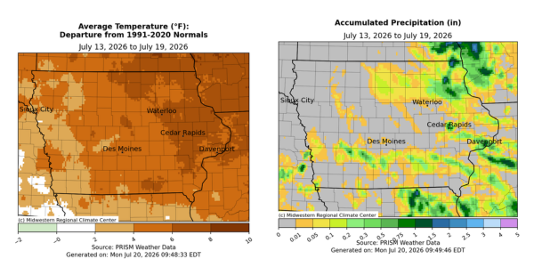
“Rainfall was sparse last week, and temperatures were 5-10 degrees above average across the state, with the warmest conditions in eastern Iowa. In the warm, dry weather, corn continues to tassel while soybeans are blooming and setting pods. While the stretch of sunshine allowed farmers to make good progress baling hay and with other fieldwork, many areas of the state would benefit from rainfall as crops continue through critical stages of development,” said Secretary Naig. “There are a few chances of thunderstorms early this week followed by a shift to more seasonal temperatures. Outlooks through the end of July show warmer temperatures hanging on with some rain chances.”
Crop Report
There were 6.7 days suitable for fieldwork during the week ending July 19, 2026. This is 2.4 days more than last year, when there were 4.3 days suitable for fieldwork. Topsoil moisture condition rated 7 percent very short, 26 percent short, 63 percent adequate, and 4 percent surplus. Subsoil moisture condition rated 5 percent very short, 27 percent short, 65 percent adequate, and 3 percent surplus. Corn silking in Iowa reached 72 percent, which is 14 percentage points ahead of last year. Eight percent of Iowa’s corn crop reached the dough stage, which is 8 percentage points behind last year. Corn condition rated 80 percent good to excellent. Soybeans blooming reached 70 percent, which is 3 percentage points ahead of last year. Soybeans setting pods reached 34 percent, which is 3 percentage points ahead of last year. Soybean condition rated 79 percent good to excellent. Oats headed reached 99 percent, which is unchanged from last year. Thirty-nine percent of oats have been harvested, which is 6 percentage points ahead of last year. Oats condition 83 percent good to excellent. Pasture condition rated 67 percent good to excellent.
The weekly report is also available on the USDA’s website at https://www.nass.usda.gov/.
Weather Summary
Provided by Justin Glisan, Ph.D., State Climatologist, Iowa Department of Agriculture and Land Stewardship
Unseasonably warm and dry conditions held across the state through the reporting period as moderate drought expanded in western Iowa. Rainfall deficits were between 0.50-1.00 inch below normal at most stations. Temperatures were warmest in eastern Iowa where positive departures approached 10 degrees; the statewide average temperature was 78.7 degrees, 5.1 degrees above normal.
Sunny skies persisted into Sunday (12th) afternoon with daytime highs in the mid 80s and light winds. Monday (13th) dawned with generally calm winds, clear skies and temperatures in the 60s. With a stable high pressure dome over the Midwest, winds turned southerly through the day as high temperatures pushed into the mid to upper 80s. Patchy fog was reported at various stations on Tuesday (14th) morning as winds were generally light with clear skies and temperatures holding in the 60s. Afternoon highs returned to the mid to upper 80s with a few stations registering low 90s. Wednesday (15th) saw partly cloudy skies in western Iowa with pockets of heavier dew and fog at many locations. Morning temperatures varied from the mid 60s northwest to low 70s southeast with calm to light northerly winds. Puffy cumulus became more widespread by the late afternoon hours, reflecting an environment becoming more favorable for upward motion; daytime temperatures rose into the upper 80s and low 90s. Clouds increased in western and northeast Iowa into Thursday (16th) with early morning temperatures in the upper 60s and low 70s. Isolated thundershowers popped into the afternoon hours with additional cells forming after midnight in eastern Iowa. Rain totals were high from central to northeast Iowa with 0.21 inch in Ankeny (Polk County), 0.63 inch at Guttenberg Lock and Dam (Clayton County) and 1.08 inches in Cedar Rapids (Linn County).
Temperatures were well above normal on Friday (17th) morning with the help of southerly winds boosting readings into the low to mid 70s. Scattered showers formed in eastern Iowa into the late afternoon and evening hours; four stations in Scott County collected more than half an inch with totals ranging from 0.62 to 0.93 inch from Davenport to Riverdale. Many stations reported measurable totals, though under 0.10 inch. An isolated line formed over northeast Iowa after midnight leaving behind 0.60 inch in Elkader (Clayton County) and 0.40 inch in Fayette (Fayette County). Winds shifted to a northerly direction through Saturday (18th) as a cold front dropped south across the state. Temperatures varied from the low 80s north to mid 90s south, where a scattered line of thunderstorms fired along the surface boundary. Ottumwa (Wapello County) reported 0.22 inch with 0.21 inch in Oskaloosa (Mahaska County) and 0.10 inch in Council Bluffs (Pottawattamie County). Morning lows over northern Iowa were seasonal on Sunday (19th), dropping into the low 60s. Upper level wildfire smoke also filtered into eastern Iowa as the heat dome began eroding.
Weekly rain totals ranged from no measurable amounts at many stations to 1.35 inches in Davenport. The statewide weekly average precipitation was 0.06 inch; the normal is 0.93 inch. Dubuque Lock and Dam (Dubuque County) reported the week’s high temperature of 96 degrees on the 18th, 11 degrees above normal. Little Sioux (Harrison County) and Spencer Municipal Airport (Clay County) reported the week’s low temperature of 55 degrees on the 19th, on average eight degrees below normal.