Iowa Crop Progress and Condition Report
July 21-27, 2025
DES MOINES, Iowa (July 28, 2025) – Iowa Secretary of Agriculture Mike Naig commented on the Iowa Crop Progress and Condition Report released by the USDA National Agricultural Statistics Service. The report is released weekly April through November. Additionally, the Iowa Department of Agriculture and Land Stewardship provides a weather summary each week during this time.
"Last week was hot and muggy as a heat dome settled over the Midwest, producing some sweltering heat and humidity,” said Secretary Naig. “Forecasts show chances for a few more thunderstorms this week, followed by a welcome break from the hot weather. With a few days to go in the month, preliminary estimates indicate it could rank among the top ten wettest Julys on record.”
The weekly report is also available on the USDA’s website at nass.usda.gov.
Crop Report
Another wet and humid week limited Iowa farmers to 3.6 days suitable for fieldwork during the week ending July 27, 2025, according to the USDA, National Agricultural Statistics Service. Field activities included harvesting oats, cutting hay and applying fungicide.
Topsoil moisture condition rated 1 percent very short, 4 percent short, 65 percent adequate and 30 percent surplus. Subsoil moisture condition rated 2 percent very short, 7 percent short, 67 percent adequate and 24 percent surplus.
Corn silking reached 84 percent, 1 day ahead of both last year and the five-year average. Thirty-four percent of Iowa’s corn has reached the dough stage, 1 day ahead of last year’s pace and 3 days ahead of normal. Corn condition rated 1 percent very poor, 2 percent poor, 10 percent fair, 59 percent good and 28 percent excellent. Soybeans blooming reached 81 percent, unchanged from last year, but 2 days behind normal. Fifty-two percent of soybeans were setting pods, 5 days ahead of last year and 2 days ahead of the five-year average. Soybean condition rated 1 percent very poor, 2 percent poor, 15 percent fair, 61 percent good and 21 percent excellent. Ninety-five percent of oats were turning color and 49 percent of the oat crop has been harvested. Oat condition rated 0 percent very poor, 3 percent poor, 14 percent fair, 67 percent good and 16 percent excellent.
The second cutting of alfalfa hay reached 87 percent complete while 28 percent of the third cutting has been completed. Hay condition rated 86 percent good to excellent. Pasture condition rated 82 percent good to excellent. Livestock stress from heat and humidity was reported.
Weather Summary
Provided by Justin Glisan, Ph.D., State Climatologist, Iowa Department of Agriculture and Land Stewardship
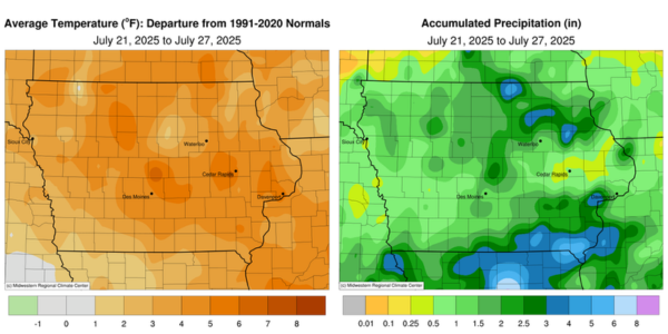
A heat dome developed over the Midwest through the reporting period, boosting air and dew point temperatures to anomalous levels. With ample moisture availability, several days of showers and thunderstorms brought widespread rainfall, adding a sixth consecutive week of unseasonably wet conditions across Iowa. Temperatures ranged from two to six degrees above the 30-year climatology with the statewide average temperature at 77.5 degrees, 4.1 degrees above normal.
Showers dissipated across eastern Iowa by noon on Sunday (20th) with isolated thunderstorms firing in central Iowa during the evening hours. Afternoon temperatures varied from the upper 70s north to mid 80s south with an easterly wind and cloudy skies. Winds shifted southeasterly into Monday (21st) morning with low temperatures in the low to mid 70s with patchy fog. Daytime temperatures were pleasant, in the upper 70s, with clouds over eastern Iowa; farther northwest, sunny skies boosted temperatures into the mid to upper 80s. Overcast conditions persisted through the nighttime hours with morning lows on Tuesday (22nd) in the low to mid 70s and patchy fog. Temperatures quickly warmed into the mid to upper 80s across western and central Iowa as the remnants of a mesoscale convective vortex moved northeast from Kansas through the day; the disturbance was a forcing mechanism for isolated severe thunderstorms to fire towards the evening hours. The complex of storms moved from central Iowa and re-intensified a few hours later in northeast Iowa, where heavy rain and stronger winds were observed. Thirty northeastern stations registered at least an inch; a narrow swath of significant rainfall was found from Oelwein (Fayette County) to Strawberry Point (Clayton County) where totals of 2.03 and 4.90 inches were reported, respectively. Wednesday (23rd) dawned unseasonably warm with morning lows in the low to mid 70s under mostly clear skies and muggy, stagnant air; the statewide average low was 72 degrees, nine degrees above normal. Southerly flow enhanced moisture advection into the state with dew points pushing into the upper 70s and low 80s and air temperatures in the upper 80s. These were ideal conditions to support a squall line and a widespread shield of rainfall to cross Iowa from northwest to southeast though the afternoon hours into Thursday (24th) morning.
The line was strongest over west-central Iowa where an 82-mph wind gust was observed in Coon Rapids (Carroll County). The heaviest rainfall was found in north-central and extreme southwest Iowa. Totals from 2.50 inches to 5.00 inches were found in Fort Dodge (Webster County) to Grafton (Worth County). Shenandoah (Page County) collected 1.81 inches while across the state, Fort Madison (Lee County) observed 2.40 inches as the system persisted for several hours. Overall, nearly 120 stations reported at least an inch with a statewide average of 0.78 inch. Partly cloudy skies remained behind the system with lower humidity and comfortable highs in the upper 70s and low 80s. Friday (25th) morning conditions were foggy in southwest and east-central Iowa with temperatures varying from the low 60s north to low 70s south. Spotty showers moved into southern Iowa into the afternoon hours and continued through the overnight hours, becoming sluggish with moderate to heavy rainfall in southeastern Iowa. The complex of showers pushed out of the state by noon on Saturday (26th), leaving behind significant totals on the order of nearly a month’s worth of rainfall at several stations. Six stations in Muscatine and Van Buren counties observed 4.95 to 5.38 inches with nearly 50 stations at or above two inches. Winds were light and variable into the afternoon with highs in the 80s. Overnight conditions into Sunday (27th) were slightly warmer than average with lows in the 70s and cloud cover over the state’s eastern half.
Weekly precipitation totals ranged from 0.12 inch at Dubuque Lock and Dam (Dubuque County) to 7.26 inches in Montrose (Lee County). The statewide weekly average precipitation was 1.58 inches while the normal is 0.97 inches. Dubuque Lock and Dam reported the week’s high temperature of 95 degrees on the 23rd, 11 degrees above normal. Hampton (Franklin County) reported the week’s low temperature of 52 degrees on the 26th, ten degrees below normal.