Iowa Crop Progress and Condition Report
June 23 – 29, 2025
DES MOINES, Iowa (June 30, 2025) – Iowa Secretary of Agriculture Mike Naig commented on the Iowa Crop Progress and Condition Report released by the USDA National Agricultural Statistics Service. The report is released weekly April through November. Additionally, the Iowa Department of Agriculture and Land Stewardship provides a weather summary each week during this time.
“Last week brought multiple rounds of rain to much of the state, marking the wettest seven days of the growing season thus far. In addition to benefitting the corn and soybeans, the moisture helps to replenish our streams, pastures and hay fields. Corn tassels are also just beginning to show after the recent warm weather, signaling crop development remains on track,” said Secretary Naig. “As July begins, Iowans can expect seasonal temperatures and fewer storm chances – pleasant conditions for a festive and fun Independence Day weekend filled with fireworks, cookouts and outdoor celebrations.”
The weekly report is also available on the USDA’s website at nass.usda.gov.
Crop Report
Precipitation, heavy in some parts of Iowa, reduced days suitable for fieldwork to just 2.7 during the week ending June 29, 2025, according to the USDA, National Agricultural Statistics Service. While beneficial, the wet conditions limited field activities throughout much of the State.
Topsoil moisture condition rated 1 percent very short, 9 percent short, 69 percent adequate and 21 percent surplus. Subsoil moisture condition rated 2 percent very short, 15 percent short, 70 percent adequate and 13 percent surplus.
Reports of corn starting to silk were received, reaching 3 percent. Corn condition rated 0 percent very poor, 2 percent poor, 13 percent fair, 63 percent good and 22 percent excellent. Soybeans blooming reached 22 percent, 3 days ahead of last year and 2 days ahead of normal. There were a few reports of soybeans setting pods. Soybean condition rated 1 percent very poor, 3 percent poor, 19 percent fair, 61 percent good and 16 percent excellent. Iowa’s oat crop reached 90 percent headed with 39 percent turning color. There were scattered reports of oats starting to be harvested. Oat condition rated 0 percent very poor, 2 percent poor, 15 percent fair, 68 percent good and 15 percent excellent.
First cutting of alfalfa hay is mostly complete, while the second cutting reached 30 percent complete. Hay condition rated 81 percent good to excellent. Pasture condition rated 73 percent good to excellent. No unusual livestock conditions were reported.
Weather Summary
Provided by Justin Glisan, Ph.D., State Climatologist, Iowa Department of Agriculture and Land Stewardship
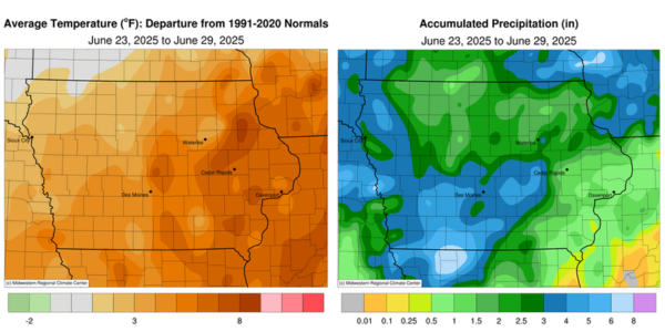
Iowa experienced the wettest reporting period of the season with widespread two to four inches of above normal rainfall from east-central through southern and western Iowa; only southeastern Iowa was near to slightly below normal. Temperatures also remained unseasonably warm with the statewide average temperature at 76.8 degrees, 3.9 degrees above normal.
Sunny skies and strong southerly winds continued through Sunday (22nd) afternoon as both dewpoint and air temperatures pushed into the 70s and 90s, respectively; the statewide average high was 92 degrees, 10 degrees above normal. Clouds increased over western Iowa into Monday (23rd) morning as a cold front moved through northwestern Iowa with morning lows hovering in the 70s. With ample moisture and temperatures in the 80s and low 90s, thunderstorms blossomed along the cold front from northeast to southwest into the evening hours, producing locally heavy rain and scattered severe wind gusts. Steady rain persisted across southern Iowa where Flash Flood Warnings were issued during the late morning. Daytime temperatures were generally in the upper 70s and low 80s with peeks of sunshine and a brief lull from widespread thunderstorms. Redevelopment of sluggish thunderstorms occurred over Iowa’s southern third around sunset and pushed into west-central Iowa by daybreak on Tuesday (24th) with additional flood warnings issued. Numerous stations from central to southwestern Iowa reported totals over 3.00 inches, with Decatur County stations of Davis City and Grand River collecting 3.05-to-5.00-inch totals, respectively. A wide swath of 1.00-to-3.00-inch totals stretched from south-central to northeast Iowa while lesser amounts were registered northwest; the overall statewide average was 0.82 inch. Portions of western Iowa experienced widespread rainfall beginning on Wednesday (25th) as another system propagated across Iowa, producing some severe straight-line winds along with local flooding in west-central counties. Over 120 stations observed at least an inch with 3.12 inches in Urbandale (Polk County) and 5.57 inches in Massena (Cass County). Amounts of 0.25-0.50 inch were widespread over the southwestern corner.
Thursday (26th) was another severe weather day over Iowa as a cold front transited the Upper Midwest. Afternoon temperatures reached into the upper 80s and low 90s ahead of the surface boundary with thunderstorms firing rapidly from southwest to northeast. Several cells turned severe, with high winds and two weak tornadoes near Corwith (Hancock County) and Lu Verne (Humboldt County). The line of storms pushed into eastern Iowa and finally out of the southwest corner by dawn on Friday (27th). Most Iowa stations received at least 0.50 inch with a west to north-central band of 2.00-4.00 inches; Carroll (Carroll County) observed 2.05 inches with 4.00 inches in Odebolt (Sac County). Clouds gradually cleared through the day with light northwesterly winds and pleasant temperatures in the upper 60s and low 70s. Winds shifted southerly into Saturday (28th) with light rain in northwestern Iowa. Afternoon temperatures pushed back into the upper 80s and low 90s under mostly sunny skies. Conditions quickly changed by midnight in northwest Iowa as a bow echo with severe-warned thunderstorms dropped large hail and strong wind gusts; a 75-mph reading was observed near Cleghorn (Cherokee County). The complex diminished in strength by Sunday (28th) morning with a few stations registering higher rainfall totals; Sioux Center (Sioux County) hit 1.01 inches.
Weekly precipitation totals ranged from 0.25 inch at Fort Madison (Lee County) to 7.13 inches in Massena. The statewide weekly average precipitation was 2.81 inches; the normal is 1.16 inches. Little Sioux (Harrison County) reported the week’s high temperature of 100 degrees on the 22nd, 16 degrees above normal. Iowa Falls (Hardin County) reported the week’s low temperature of 57 degrees on the 28th, four degrees below normal.