Iowa Crop Progress and Condition Report
May 18 – 24, 2026
DES MOINES, Iowa (May 26, 2026) — Iowa Secretary of Agriculture Mike Naig commented on the Iowa Crop Progress and Condition Report released by the USDA National Agricultural Statistics Service. The report is released weekly April through November. Additionally, the Iowa Department of Agriculture and Land Stewardship provides a weather summary each week during this time.
“After a rough stretch of severe weather, farmers welcomed a break from the thunderstorms and headed back to the fields, with many areas getting closer to wrapping up planting,” said Secretary Naig. “Following a warm and sunny Memorial Day in most parts of the state, weather outlooks through the end of May show a likelihood of warmer temperatures and drier conditions.”
Crop Report
There were 4.0 days suitable for fieldwork during the week ending May 24, 2026. This is 0.2 days more than last year, when there were 3.8 days suitable for fieldwork. Topsoil moisture condition rated 3 percent very short, 22 percent short, 70 percent adequate and 5 percent surplus. Subsoil moisture condition rated 4 percent very short, 20 percent short, 69 percent adequate and 7 percent surplus.
Corn planted in Iowa reached 94 percent, which is equal to last year’s pace. Corn emerged reached 72 percent. Ninety percent of the expected soybean crop has been planted, 1 percentage point behind last year. Soybeans emerged reached 57 percent complete, which is on par with last year. Ninety-eight percent of the state’s oat crop has been planted, while 95 percent has emerged. Oats headed reached 16 percent. Oat condition rated 84 percent good to excellent. Pasture condition rated 75 percent good to excellent.
The weekly report is also available on the USDA’s website at https://www.nass.usda.gov/.
Weather Summary
Provided by Justin Glisan, Ph.D., State Climatologist, Iowa Department of Agriculture and Land Stewardship
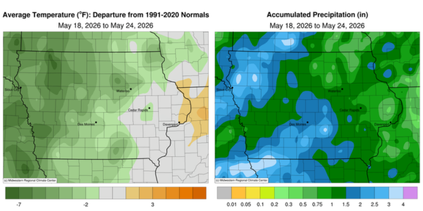
Early week severe weather yielded to a much quieter weather pattern by the weekend. However, numerous tornadoes were reported in northwest and southwest Iowa along with several hail and straight-line wind reports. Along with these thunderstorms, much of Iowa experienced unseasonably wet conditions. Temperatures moderated as well with cooler conditions over much of the western three-quarters of the state; the statewide average temperature was 58.8 degrees, 3.1 degrees below normal.
A strong cold front clashed with an unseasonably warm and unstable atmosphere over western Iowa later in the afternoon and evening on Sunday (17th). Supercells quickly formed along the South Dakota–Nebraska border and swept eastward, becoming tornado-warned from just south of Sioux City (Woodbury County) into north-central Iowa as the line advanced and bowed out. Storms largely dropped below the severe threshold around midnight as the complex moved into eastern Iowa. The preliminary number of tornadoes was 20, with all being rated at EF-1 or weaker. Numerous strong straight-line wind gusts were observed along the line with an 82-mph gust in Gruver (Emmet County) and an 88-mph reading in Correctionville (Woodbury County). Rainfall totals at 7:00 am on Monday (18th) were widespread with all stations reporting measurable totals; amounts between 0.50-0.75 inch were common with the highest totals of 2.00 inches in Le Mars (Plymouth County), 3.00 inches in Bedford (Taylor County) and a statewide average of 0.64 inch. Instability increased through the afternoon hours across southwest Iowa as another cold front crossed into the western extent of the state. Outflow boundaries from earlier thunderstorms interacted with surface boundaries in Nebraska firing off strong thunderstorms in the northeast corner. These storms gathered energy and sped into southwest Iowa towards the evening hours. Over the next few hours, four weak tornadoes were observed across southern Iowa. There was also a long and narrow swath of very heavy rainfall where strong supercells were found; Osceola (Clarke County) hit 2.02 inches with 3.18 inches in Pella (Marion County) and 5.30 inches in Mount Ayr (Ringgold County).
Tuesday (19th) dawned with overcast skies, gusty northwesterly winds and lows in the mid 40s to low 50s over the western two-thirds of Iowa; temperatures were still in the 60s in eastern Iowa, which was still ahead of the transiting cold front. Clouds remained through the day as afternoon highs held in the 50s. Skies cleared into Wednesday (20th) as morning lows dropped into the 30s west to mid 40s east. Daytime conditions were mostly sunny with northeasterly winds and temperatures in the mid 50s to mid 60s. Clouds increased overnight into Thursday (21st) with light showers pushing across portions of the state. Temperatures were similar to the previous day though the southeast corner of Iowa pushed into the upper 60s. Rain showers became more widespread over northwestern Iowa after sunset as a low-pressure center propagated through Minnesota. Stations across the northwest one-third collected at least 0.25 inch with several others registering over an inch; Spencer Municipal Airport (Clay County) observed 1.04 inches while Sioux City Airport reported 1.48 inches. Friday (22nd) was a partly sunny day with pleasant temperatures in the 60s and light southeasterly winds. Winds turned northwesterly into Saturday (23rd) morning as a weak cold front exited the state. Daytime temperatures held in the low to mid 70s with ample sunshine. Over conditions remained clear with a quarter gibbous moon and temperatures in the 50s.
Weekly precipitation totals ranged from 0.15 inch at Decorah Municipal Airport (Winneshiek County) to 5.50 inches in Mount Ayr (Ringgold County). The statewide weekly average precipitation was 1.51 inches; the normal is 1.12 inches. Little Sioux (Harrison County) reported the week’s high temperature of 89 degrees on the 24th, 14 degrees above normal. Northwood (Worth County) reported the week’s low temperature of 30 degrees on the 20th, 17 degrees below normal.