Iowa Crop Progress and Condition Report
May 20-26, 2024
DES MOINES, Iowa (May 28, 2024) – Iowa Secretary of Agriculture Mike Naig commented on the Iowa Crop Progress and Condition Report released by the USDA National Agricultural Statistics Service. The report is released weekly April through November. Additionally, the Iowa Department of Agriculture and Land Stewardship provides a weather summary each week during this time.
“Our hearts go out to all the Iowans and communities who have been affected by the recent rounds of devastating severe weather. The outpouring of support for those affected highlights the remarkable strength of our state and its people. Iowans are resilient and we will get through this together,” said Secretary Naig. “Planting progresses as conditions allow, but many farmers continue to face delays. Outlooks into the first week of June show elevated chances of warmer temperatures and near-normal rainfall chances, which hopefully will lead to conditions more favorable for field work.”
The weekly report is also available on the USDA’s website at nass.usda.gov.
Weather Summary
Severe weather including heavy rains, tornadoes, and derecho conditions limited Iowa farmers to 2.3 days suitable for fieldwork during the week ending May 26, 2024, according to the USDA, National Agricultural Statistics Service. Planting corn and soybeans, and cutting hay was limited. Topsoil moisture condition rated 0 percent very short, 3 percent short, 71 percent adequate and 26 percent surplus. Subsoil moisture condition rated 2 percent very short, 9 percent short, 72 percent adequate and 17 percent surplus. Corn planted reached 88 percent. Sixty-six percent of the corn crop has emerged. The first corn condition rating of the season was 1 percent very poor, 4 percent poor, 22 percent fair, 54 good and 19 percent excellent. Seventy-three percent of Iowa’s expected soybean crop has been planted, 10 days behind last year and 3 days behind the normal. Soybeans emerged reached 42 percent, 5 days behind last year. Ninety-five percent of the expected oat crop has emerged. Oats headed reached 31 percent, 6 days ahead of last year and almost 2 weeks ahead of the average. Oat condition improved 5 percentage points to 81 percent good to excellent. Alfalfa hay reached 20 percent complete. Hay condition rated 78 percent good to excellent. Pasture condition rated 72 percent good to excellent. Reports of flooded fields were received throughout the State.
Weather Summary
Provided by Justin Glisan, Ph.D., State Climatologist, Iowa Department of Agriculture and Land Stewardship
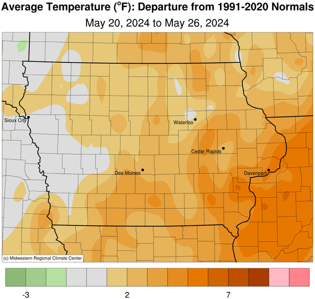
Iowans experienced one of the most active reporting periods in recent memory with nearly 30 tornadoes, a late week derecho and anomalously wet conditions; many northeastern stations reported at least 350% of normal rainfall. Temperatures were near-normal west to six degrees above normal east; the statewide average temperature was 64.9 degrees, 2.0 degrees above normal.
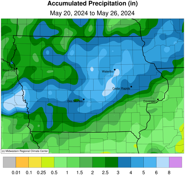
Scattered strong thunderstorms rumbled across the state into Sunday (19th) afternoon and evening with a more organized line forming in eastern Iowa towards midnight. Thunderstorms persisted through late morning on Monday (20th) with temperatures in the low 50s northwest to mid 60s southeast. Event rain totals were highest across a southwest to northeast swath with 18 central to south-central stations receiving at least 2.00 inches; Osceola (Clarke County) observed 2.80 inches while 2.95 inches was reported in Sully (Jasper County). Widespread 0.50-1.00-inch totals were also reported with a statewide average of 0.67 inch. Thunderstorms fired across northern and western Iowa along a warm front after sunset with several storms becoming severe and tornado warned. Thunderstorms became more widespread into Tuesday (21st) morning as an initial squall line sped east and into Wisconsin by noon. Clearing skies in western Iowa along with anomalously high atmospheric instability and wind shear produced explosive convection near the Iowa-Nebraska border. A rare “Particularly Dangerous Situation” Tornado Watch was issued for most of Iowa as supercells became tornado-warned almost immediately. There were several reports of multi-vortex tornadoes in southwest Iowa with Greenfield (Adair County) taking a direct hit from a higher-end EF-4; sadly, there were 35 injuries and five fatalities. The long-track supercells sped at nearly 40 mph into central Iowa where additional tornadoes formed between Des Moines (Polk County) and Nevada (Story County). As the line evolved, widespread reports of severe straight-line winds continued into eastern Iowa along with moderate to heavy rainfall and some hail. Over the preceding 36 hours, 140 stations reported over 2.00 inches with remarkable totals in the 4.00 to 6.00 inch-range in central to western Iowa; Polk City (Polk County) registered 4.01 inches with a 6.14-inch total at Missouri Valley (Harrison County) and a statewide average of 1.57 inches.
Clouds cleared from west to east into Wednesday (22nd) morning with temperatures rising into the low 70s during the afternoon hours. Winds shift southerly overnight into Thursday (23rd) with skies remaining mostly sunny through the daytime, though clouds increased into the nighttime hours as a power disturbance approached from the west. An intense squall line racing out of Nebraska spawned at least 18 tornadoes as it plowed across Iowa into Friday (24th) morning. The line bowed out in the center as a rear-inflow jet strengthened straight-line winds along the length of the line. Hail and heavy rain were also reported across the length of squall. With numerous wind gusts at or above 58 mph along the path length of at least 400 miles, the event was categorized as a derecho. Thunderstorms continued to fire through the afternoon hours before dissipating around sunset. Skies cleared as winds became variable and temperatures dropped into the upper 40s and low 50s. Event rain totals at 7:00 am on Saturday (25th) were highest in eastern Iowa with nearly 100 stations receiving at least an inch with 20 approaching 2.00 inches; Dubuque (Dubuque County) measured 1.50 inches while Chariton (Lucas County) hit 1.96 inches. Afternoon conditions were pleasant with southerly winds and highs in the low to mid 70s. Another disturbance pushed into Iowa on Sunday (26th) morning bringing isolated severe-warned thunderstorms and additional heavy rain, especially in northeast Iowa; many of the stations received totals between 0.75-1.50 inches. Skies cleared in western Iowa where morning lows were in the upper 50s and low 60s.
Weekly precipitation totals ranged from 0.75 inch at Keokuk Lock and Dam (Jones County) to 8.63 inches in Vining (Tama County). The statewide weekly average precipitation was 3.41 inches; more than triple the normal of 1.10 inches. Davenport Municipal Airport (Scott County) reported the week’s high temperature of 91 degrees on the 21st, 17 degrees above average. Elkader (Clayton County) and Stanley (Buchanan County) reported the week’s low temperature of 41 degrees on the 25th, on average nine degrees below normal. Four-inch soil temperatures were in the 60s as of Sunday.