Iowa Crop Progress and Condition Report
Nov. 4–Nov. 10, 2024
DES MOINES, Iowa (Nov. 12, 2024) — Iowa Secretary of Agriculture Mike Naig commented on the Iowa Crop Progress and Condition Report released by the USDA National Agricultural Statistics Service. The report is released weekly April through November. Additionally, the Iowa Department of Agriculture and Land Stewardship provides a weather summary each week during this time.
“Between periods of rain last week, the unseasonably warm temperatures helped Iowa farmers continue to wrap up harvest and complete other field work,” said Secretary Mike Naig. “The widespread rainfall over the last few weeks has been beneficial in improving drought conditions across large swaths of Iowa. We can expect the warmer temperatures and more active weather pattern to continue as we head toward Thanksgiving.”
The weekly report is also available on the USDA’s website at nass.usda.gov.
Crop Report
Moderate rainfall during the week slowed harvest as Iowa’s farmers had an average of 3.3 days suitable for fieldwork during the week ending November 10, 2024, according to the USDA, National Agricultural Statistics Service. Field activities included harvesting row crops, completing fall tillage, baling stalks, and applying fall fertilizer and manure.
Topsoil moisture condition rated 12 percent very short, 36 percent short, 50 percent adequate and 2 percent surplus. Subsoil moisture condition rated 19 percent very short, 45 percent short, 35 percent adequate and 1 percent surplus.
Harvest of the corn for grain crop reached 95 percent statewide, 4 days ahead of last year and 12 days ahead of the five-year average. Farmers in south central Iowa still have over 15 percent of their corn for grain remaining to be harvested. Moisture content of field corn harvested for grain remained steady at 14 percent.
Livestock producers reported muddy feedlots.
Weather Summary
Provided by Justin Glisan, Ph.D., State Climatologist, Iowa Department of Agriculture and Land Stewardship
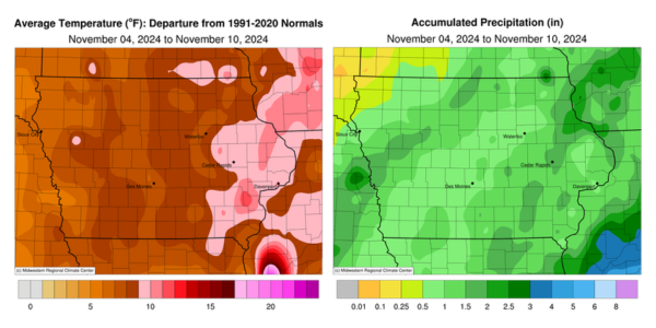
Unseasonably wet conditions were observed across much of Iowa for the second consecutive reporting period with the highest totals found in northeast Iowa. Temperatures remained well above average with positive departures of 10-14 degrees in eastern Iowa; the statewide average temperature was 48.3 degrees, 8.9 degrees above normal.
Showers continued through much of Sunday (3rd) with moderate rainfall reported across eastern Iowa. Afternoon temperatures held in the mid to upper 50s under overcast skies. A second round of showers on the backside of the low pressure center moved through northwestern Iowa into Monday (4th). Rainfall totals were highest in eastern Iowa with most stations registering between 0.50 and 1.00 inch. A swath of northeastern Iowa reported higher totals ranging from 1.10 inches in McGregor (Clayton County) to 2.30 inches at Dubuque Lock and Dam (Dubuque County). Stations across western Iowa saw general amounts of a few tenths of an inch with totals between 1.32 and 1.50 inches at multiple Harrison County locations; the statewide average rainfall was 0.48 inch. Overcast skies persisted for much of the afternoon with highs ranging from the low 50s north to mid 60s south. Rain showers returned to southern Iowa towards the evening and broadened to cover much of Iowa. The system slowly moved across Iowa into Tuesday (5th) with northwestern Iowa reporting light rainfall through the late morning hours. An additional line of showers with moderate rainfall formed in eastern Iowa along a cold front before the system cleared the state. Most Iowa stations reported at least 0.25 inch with the highest event totals in western and east-central Iowa; Cedar Rapids (Linn County) registered 1.02 inches while Oskaloosa (Mahaska County) observed 2.11 inches. Clouds began clearing behind the system with widespread fog reported near daybreak on Wednesday (6th) with morning lows in the mid 30s west to mid 40s east. Afternoon conditions were generally clear statewide with variable winds and temperatures climbing into the upper 40s and low 50s.
Widespread fog was observed again on Thursday (7th) morning as clear skies and calm to light winds produced ideal conditions. Westerly winds increased through the daytime hours as temperatures rose into the 50s under sunny skies. Wind shifted southwesterly overnight with morning lows on Friday (8th) holding in the low 30s north to low 40s south. The afternoon hours were sunny with light, variable winds and temperatures in the upper 50s and low 60s. Clouds increased over southwestern Iowa after sunset as a low pressure system approached the state. Showers spread across the southwest corner and expanded over much of the state into Saturday (9th) morning. Rainfall persisted in eastern Iowa through the day as high temperatures held in the upper 40s for most stations. The low pressure center continued to move across northwestern Iowa into Sunday (10th), producing additional showers. Rain totals reported at 7:00 am were in the 0.25-0.50 inch range over much of western Iowa with 0.10-0.25 inch totals farther east; Storm Lake (Buena Vista County) reported 0.47 inch while Grafton (Worth County) recorded 0.96 inch.
Weekly precipitation totals ranged 0.02 inch in Rock Rapids (Lyon County) to 2.93 inches at Dubuque Lock and Dam. The weekly statewide average precipitation was 1.14 inches; the normal is 0.52 inch. Columbus Junction (Louisa County) and Donnellson (Lee County) reported the week’s high temperature of 71 degrees on the 4th, on average 16 degrees above normal. Several stations reported the week’s low temperature of 29 degrees on the 7th and 8th, 1.1 degrees below normal.
