Weekly Crop Progress and Condition Report
Sept. 9–15, 2024
DES MOINES, Iowa (Sept. 16, 2024) – Iowa Secretary of Agriculture Mike Naig commented on the Iowa Crop Progress and Condition Report released by the USDA National Agricultural Statistics Service. The report is released weekly April through November. Additionally, the Iowa Department of Agriculture and Land Stewardship provides a weather summary each week during this time.
“The unseasonably warm temperatures and dry conditions over the past week allowed farmers to chop silage, seed cover crops, top off propane tanks, and make additional harvest preparations. There have also been reports of some harvest activity in pockets of the state, though forecasts are showing chances for widespread rainfall later this week that could temporarily park some combines,” said Secretary Naig. “National Farm Safety and Health Week is a timely reminder for all farmers and drivers to do our part to ensure a safe and productive harvest season for everyone in the field, around the farm and on the road. Given the stress and long hours of harvest as well as challenges in the ag economy, it’s also important for farmers and those involved in agriculture to prioritize their mental health and well-being.”
The weekly report is also available on the USDA’s website at nass.usda.gov.
Crop Report
Iowa experienced hot and dry conditions this week. These conditions allowed Iowa farmers 6.7 days suitable for fieldwork during the week ending September 15, 2024, according to the USDA, National Agricultural Statistics Service. Field activities included chopping corn silage and harvesting corn and soybeans.
Topsoil moisture condition rated 6 percent very short, 38 percent short, 55 percent adequate and 1 percent surplus. Subsoil moisture condition rated 6 percent very short, 32 percent short, 61 percent adequate and 1 percent surplus.
Corn in the dent stage or beyond reached 85 percent this week, 8 days behind last year and 2 days behind the five-year average. Corn mature reached 41 percent, 4 days behind last year but 2 days ahead of the average. Corn harvested for grain began this week at 2 percent. Corn condition was rated 77 percent good to excellent. Soybeans coloring or beyond reached 72 percent, 3 days behind last year but 2 days ahead of the five-year average. Soybean dropping leaves reached 31 percent, 3 days behind last year. The soybean harvest began this week at 1 percent. Soybean condition was 77 percent good to excellent.
The State’s third cutting of alfalfa hay reached 96 percent, 9 days behind last year but 1 week ahead of the five-year average. Pasture condition fell 11 percentage points to 52 percent good to excellent.
Weather Summary
Provided by Justin Glisan, Ph.D., State Climatologist, Iowa Department of Agriculture and Land Stewardship
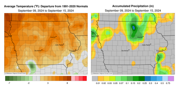
A dome of high pressure dominated the region over the reporting period, preventing widespread showers and thunderstorms. All of Iowa’s stations reported rainfall deficits. Unseasonably warm conditions also returned to Iowa with positive departures approaching six degrees over northwestern Iowa; the statewide average temperature was 69.1 degrees, 4.0 degrees above normal.
Sunday (8th) afternoon was sunny with westerly winds and temperatures in the low to mid 70s statewide. Winds swung to the south overnight with morning temperatures on Monday (9th) in the upper 40s and low 50s. Afternoon temperatures warmed through the low 80s across western Iowa, while upper 70s were observed farther east. Clouds increased over central and northern Iowa overnight into Tuesday (10th) as an upper level disturbance brought showers to northern Iowa towards daybreak. Scattered showers continued to move east through the daytime hours. Persisting southerly winds boosted temperatures into the upper 70s and low 80s. Rainfall totals were under 0.10 inch with totals ranging from 0.01 inch in Orange City (Sioux County) to 0.09 inch in Waterloo (Black Hawk County). Clear skies reemerged on Wednesday (11th) with low temperatures in the mid to upper 50s. Afternoon conditions warmed into the mid to upper 80s across most of Iowa with slightly cooler temperatures southeast. Winds gradually shifted southeasterly as patchy clouds crossed starry skies with temperatures dropping into the 50s north and low 60s southwest. Thursday (12th) afternoon temperatures warmed into the 80s as gusty southeasterly winds continued under sunny skies. A shift to light easterly winds occurred through the overnight hours as lows ranged from the upper 50s north to low 60s south.
Morning lows on Friday (13th) varied from the mid 50s northwest to mid 60s southeast with light, variable winds and mostly clear skies. Higher level clouds from the northern remnants of Hurricane Francine clipped southeastern Iowa through the afternoon hours with temperatures in the upper 70s and low 80s. A narrow line of showers formed in central Iowa into the evening, though much of the rain evaporated before hitting the surface. Additional showers formed in northeastern Iowa very early on Saturday (14th) with lighter totals reported at several stations; Charles City (Floyd County) registered 0.14 inch while Mason City (Cerro Gordo County) recorded 0.30 inch. Partly to mostly cloudy skies remained into the late afternoon with gradual clearing west to east. Spotty thundershowers formed along the Iowa-Illinois border around sunset with measurable totals at a handful of stations; the National Weather Service office in Davenport (Scott County) collected 0.09 inch. Muggy conditions were reported on Sunday (15th) morning with dewpoints and air temperatures in the low to mid 60s.
Weekly precipitation totals ranged from no accumulation across most of Iowa to 0.35 inch at Rockwell (Cerro Gordo County). The statewide weekly average precipitation was 0.03 inch while the normal is 0.85 inch. Little Sioux (Harrison County) reported the week’s high temperature of 90 degrees on the 9th, 11 degrees above normal. Elkader (Clayton County) reported the week’s low temperature of 38 degrees on the 9th, 13 degrees below normal.
