Iowa Crop Progress and Condition Report
Sept. 22 –28, 2025
DES MOINES, Iowa (Sept. 29, 2025) – Iowa Secretary of Agriculture Mike Naig commented on the Iowa Crop Progress and Condition Report released by the USDA National Agricultural Statistics Service. The report is released weekly April through November. Additionally, the Iowa Department of Agriculture and Land Stewardship provides a weather summary each week during this time.
“Combines are rolling all across Iowa,” said Secretary Naig. “The warm and dry weather is allowing farmers to make good progress on corn and soybean harvest. With the favorable weather expected to hold through next week, farmers should be able to continue making harvest headway, though conditions may be a bit dusty. As we get a little further into the start of October, outlooks are indicating a possible shift back to more chances of widespread rain.”
The weekly report is also available on the USDA’s website at nass.usda.gov.
Crop Report
Dry conditions allowed 6.2 days suitable for fieldwork during the week ending September 28, 2025, according to the USDA, National Agricultural Statistics Service. The warm temperatures also quickly advanced crop maturity. Fieldwork included harvesting corn and soybeans.
Topsoil moisture condition rated 5 percent very short, 22 percent short, 65 percent adequate and 8 percent surplus. Subsoil moisture condition was 3 percent very short, 20 percent short, 70 percent adequate and 7 percent surplus.
Nearly all the corn was dented or beyond. Eighty percent of corn has matured, 4 days ahead of last year and 1 day ahead of the five-year average. The corn for grain harvest was 15 percent complete, 4 days ahead of last year and 3 days ahead of average. Moisture content of field corn being harvested for grain was 20 percent. Corn condition was rated 1 percent very poor, 5 percent poor, 23 percent fair, 53 percent good and 18 percent excellent. Soybeans coloring was nearly complete at 95 percent. Eighty-three percent of soybeans were dropping leaves, 3 days ahead of last year and 2 days ahead of average. Soybean harvest was 17 percent complete, 3 days behind last year and the average. Soybean condition rated 1 percent very poor, 4 percent poor, 22 percent fair, 55 percent good and 18 percent excellent.
Pasture condition rated 53 percent good to excellent.
Weather Summary
Provided by Justin Glisan, Ph.D., State Climatologist, Iowa Department of Agriculture and Land Stewardship
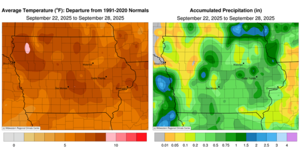
September’s last full reporting period continued the recent unseasonably warm streak, with temperatures approaching 10 degrees above normal in northwestern Iowa. The statewide average temperature was 67.5 degrees, 8.1 degrees above normal. Rainfall was also below normal at most of Iowa’s reporting stations, with widespread departures of 0.50–0.75 inch.
Light showers dissipated across southwestern Iowa by Sunday (21ˢᵗ) afternoon as daytime highs rose into the upper 70s and low 80s under southerly winds. A few severe-warned thunderstorms developed over northwestern Iowa after sunset, though they dissipated within a few hours. Several stations reported moderate rainfall totals, including 0.44 inch in Ireton (Sioux County). Additional thunderstorms formed along the northeastern portion of the Iowa–Minnesota border by sunrise on Monday (22ⁿᵈ), with Decorah (Winneshiek County) receiving 0.48 inch. A west-to-east oriented surface boundary shifted south through the day as highs reached the mid 80s with persistent southerly flow. By the late afternoon, sufficient instability had materialized along the front over northern Iowa, allowing strong thunderstorms to develop. There were several reports of one-inch hail, with hailstones up to two inches observed in Sutherland (O’Brien County). Individual cells merged into a line that slowly moved into central Iowa as additional storms formed in west-central Iowa. Although the line weakened as it advanced into southern Iowa, moderate rain showers continued into Tuesday (23ʳᵈ) morning. More than 30 stations recorded at least an inch of rainfall, with the highest totals in pockets of northeastern Iowa and from west-central to southwestern Iowa. A gauge in Dubuque (Dubuque County) measured 2.13 inches, while 2.22 inches fell in Jefferson (Greene County). Outside of these amounts, much of the state’s southeastern half recorded between 0.20 and 0.60 inch. Winds shifted northerly into Wednesday (24ᵗʰ), bringing morning fog over northern Iowa and lows in the mid 50s to low 60s from north to south. Afternoon conditions were partly cloudy, with statewide temperatures ranging from the mid to upper 70s.
Clear skies prevailed into Thursday (25ᵗʰ), with morning temperatures from the upper 40s in the northwest to the low 50s in the southeast, accompanied by reports of patchy fog. Daytime conditions remained pleasant, with light and variable winds, clear skies and highs in the upper 70s to low 80s. Winds returned to a southerly direction as clear skies persisted into Friday (26ᵗʰ). Afternoon highs reached the low to mid-80s, with a pocket of upper 80s in east-central Iowa under sunny skies. On Saturday (27ᵗʰ), morning temperatures were in the 50s under cloudless skies with light southerly winds. A cold front dropped southeast through the day, shifting winds to a northwesterly direction while skies remained clear. Behind the front, highs held in the mid 70s, with low to mid 80s over southeastern Iowa; a few eastern stations recorded readings in the 90s. The statewide average high was 83 degrees, 12 degrees above normal. A few clouds drifted across Iowa into Sunday (28ᵗʰ), with chilly morning lows dipping into the 40s in northern Iowa and the upper 50s farther south.
Weekly precipitation totals ranged from no accumulation at numerous northern stations to 2.22 inches in Jefferson. The statewide weekly average rainfall was 0.41 inch, compared with a normal of 0.76 inch. The National Weather Service office in Davenport (Scott County) reported the week’s high temperature of 91 degrees on the 27ᵗʰ, 18 degrees above normal. Spencer Municipal Airport (Clay County) observed the week’s low temperature of 39 degrees on the 28ᵗʰ, six degrees below normal.