Iowa Crop Progress and Condition Report
March 29-April 4, 2021
DES MOINES, Iowa (April 5, 2021) — Iowa Secretary of Agriculture Mike Naig today commented on the Iowa Crop Progress and Conditions report released by the USDA National Agricultural Statistics Service. The report is released weekly from April through November.
“With recent warm and dry conditions across the state, many farmers are eager to begin fieldwork with an eye towards planting,” said Secretary Naig. “Farmers should be cautious though as cold snaps and a late spring freeze are possible through the end of April. Chances of rain are also back in the forecast.”
The weekly report is also available on the USDA’s website at nass.usda.gov.
Crop Report
Warm and dry days allowed Iowa farmers 4.3 days suitable for fieldwork during the week ending April 4, 2021, according to the USDA, National Agricultural Statistics Service. Fieldwork activities included applying anhydrous and fertilizer, spreading manure and planting oats.
Topsoil moisture levels rated 8% very short, 25% short, 64% adequate and 3% surplus. Subsoil moisture levels rated 12% very short, 29% short, 56% adequate and 3% surplus.
Twelve percent of the expected oat crop has been planted, 3 days ahead of last year and 4 days ahead of the 5- year average.
Pastures have started to green. Livestock conditions were generally good and producers report calving is going well.
Weather Summary
Provided by Justin Glisan, Ph.D., State Climatologist, Iowa Department of Agriculture and Land Stewardship
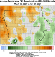
Several transient weather systems propagated through the Midwest over the reporting period, leading to several days with very gusty winds across Iowa. Unseasonably dry conditions reigned statewide with no National Weather Service coop station observing measurable rainfall. Temperatures varied from above normal west to below normal east with a statewide average temperature of 43.9 degrees, 0.8 degree above normal.
Partly to mostly sunny skies greeted Iowa through Sunday (28th) afternoon. Winds gradually increased and switched from the northwest to the southeast during the late evening hours, in advance of strong low pressure systems across the Dakotas. Daytime highs ranged from the low 40s east, where more cloud cover was present, to the mid 50s in the southwest. Overnight into Monday (29th), a warm front lifted north through Iowa with very gusty southerly winds pushing afternoon highs into the low to mid 70s. Spencer Municipal Airport (Clay County) observed 76 degrees, 26 degrees above normal; Iowa’s average high temperature was 72 degrees, 18 degrees warmer than normal. Very strong wind gusts were observed statewide with Sioux City Gateway Airport (Woodbury County) recording a 56 mph gust; sustained winds pushed into the 20 to 40 mph range. A strong cold front moved through Iowa on Tuesday (30th) dropping temperatures into a more seasonal range as blustery northwest winds and mostly clear skies persisted into the nighttime hours. Overnight lows reported at 7:00 am on Wednesday (31st) were in the low 20s northwest to low 30s southeast. Mostly cloudy skies were reported over eastern Iowa, holding afternoon highs in the low to mid 30s; Oelwein Municipal Airport (Fayette County) reported a high temperature of 32 degrees while Clarinda (Page County) observed 47 degrees, 10 degrees below normal.
Temperatures remained unseasonably cool on Thursday (1st) as a high pressure center moved slowly through Iowa producing light and variable winds. Afternoon conditions were generally clear with temperatures in the upper 40s and low 50s. Southerly winds picked back up overnight in advance of another upper-level disturbance; with a very tight pressure gradient across Iowa, wind speeds on Friday (2nd) were in the upper 20s to mid 30 mph range. Under gusty conditions and sunny skies, temperatures rebounded into the upper 60s in western Iowa to the mid 50s east. Overnight lows into Saturday remained above average, generally in the 40s under starry skies. Clear conditions continued through Saturday (3rd) with some high-level cirrus passing through. Temperatures were very pleasant for early April with highs pushing into the low to mid 70s; the statewide average high was 72 degrees, 16 degrees above normal. Overnight lows into Sunday (4th) remained above average with temperatures in the upper 30s and 40s statewide.
While the weekly statewide precipitation normal is 0.69 inch, there was no measurable precipitation reported across Iowa. Sioux City Airport (Woodbury County) reported the week’s high temperature of 78 degrees on the 3rd; this reading was 21 degrees above average. Estherville Municipal Airport (Emmet County) reported the week’s low temperature of 11 degrees on the 1st, which is 19 degrees below normal. Four-inch soil temperatures were in the upper 40s east to mid 50s west as of Sunday.