Iowa Crop Progress and Condition Report
Sept. 11-17, 2023
DES MOINES, Iowa (Sept. 18, 2023) — Iowa Secretary of Agriculture Mike Naig commented on the Iowa Crop Progress and Condition Report released by the USDA National Agricultural Statistics Service. The report is released weekly April through November. Additionally, the Iowa Department of Agriculture and Land Stewardship provides a weather summary each week during this time.
“With harvest ramping up in parts of Iowa, weather outlooks are hinting at warmer temperatures and greater chances of rain into early October,” said Secretary Naig. “It’s National Farm Safety and Health Week. Throughout harvest, I encourage all Iowans to keep safety in the field and on the road top of mind.”
The weekly report is also available on the USDA’s website at nass.usda.gov.
Crop Report
The southern tier of Iowa received above average rainfall this week leading to 6.1 days suitable for fieldwork statewide during the week ending September 17, 2023, according to the USDA, National Agricultural Statistics Service. Field activities included harvesting corn and soybeans. Some farmers were also working on their fourth cutting of alfalfa hay.
Topsoil moisture condition rated 34 percent very short, 45 percent short, 20 percent adequate and 1 percent surplus. Subsoil moisture condition rated 37 percent very short, 43 percent short, 19 percent adequate and 1 percent surplus.
Corn in the dent stage or beyond was 96 percent this week, 6 days ahead of last year and 11 days ahead of the 5-year average. Sixty-three percent of the State’s corn crop has reached maturity, 8 days ahead of both last year and normal. Corn harvested for grain reached 5 percent statewide, roughly 1 week ahead of both last year and the average. Moisture content of field corn being harvested for grain was at 22 percent. Corn condition improved slightly to 48 percent good to excellent. Soybeans coloring or beyond reached 86 percent, 6 days ahead of both last year and the average. Soybeans dropping leaves or beyond was 52 percent this week, 6 days ahead of last year and 5 days ahead of normal. Three percent of the soybean crop has been harvested. Soybean condition also rose slightly to 47 percent good to excellent.
Pasture condition rated 15 percent good to excellent. Getting water to livestock continued be a challenge for producers this week, with reports of livestock taken off pastures where ponds and creeks have dried up.
Weather Summary
Provided by Justin Glisan, Ph.D., State Climatologist, Iowa Department of Agriculture and Land Stewardship
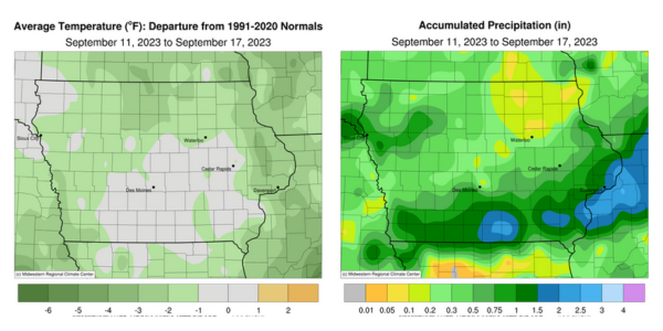
Showers and some thunderstorms gradually expanded over Iowa through Sunday (10th) afternoon with temperatures ranging from the mid-60s north to the low 80s south. Rain persisted overnight across Iowa’s southeastern half through late Monday (11th) morning, gradually dissipating by noon. The southern half of Iowa received general rain totals above 0.50 inch from the event with much of northern Iowa reporting a few tenths. Nearly 60 stations collected at least an inch as south-central counties experienced the highest totals, ranging from 2.04 inches at Allerton (Wayne County) to 2.25 inches in Mount Ayr (Ringgold County); the statewide average total was 0.59 inch. Winds shifted to the northeast as clouds gradually thinned with afternoon highs in the low to mid 70s. Light showers pushed into northwest Iowa after midnight on Tuesday (12th) leaving Rock Rapids (Lyon County) with a 0.18-inch total before diminishing near daybreak. Morning lows were in the upper 40s and low 50s with clouds and patchy fog in northern Iowa. Daytime temperatures reached the 70s as scattered thunderstorms formed in north-central to eastern Iowa. The storms fizzled out after sunset, leaving behind general amounts under 0.25 inch; higher totals ranged from 0.32 inch at Hopkinton (Delaware County) to 0.47 inch near Clinton (Clinton County). Partly cloudy skies developed statewide into Wednesday (13th) with light northerly winds and lows in the upper 40s to low 50s at most stations. Afternoon conditions were cooler in northeast Iowa with highs in the mid-60s, while temperatures farther west were up to 15 degrees warmer.
Early Thursday (14th) temperatures showed a large spread across the state; northeast stations reported low to mid 40s while low 60s were reported in the southwest corner. Upper 70s and low 80s greeted Iowans through the day as southwesterly winds increased along with evening cloud cover in western Iowa, ahead of a cold front. Showers formed along the boundary into the daytime hours on Friday (15th) with widespread totals reported over Iowa’s northwest corner. Scattered thundershowers fired in south-central Iowa along with an isolated severe-warned evening storm in Sioux County; Orange City measured a 0.77-inch total with Rock Rapids (Buena Vista County) reporting 0.90 inch. Totals outside of these higher amounts were a few tenths of an inch. Foggy conditions formed overnight into Saturday (16th) with lows behind the boundary in the upper 40s; temperatures ahead of the front remained in the mid-60s. A cluster of showers and thunderstorms pushed from central Iowa into the southeast corner through the afternoon hours as a secondary complex fired along the Mississippi River in northeastern Iowa. Rathbun Dam (Appanoose County) observed 0.50 inch with Chariton (Lucas County) and DeWitt (Clinton County) reporting 1.08 and 1.62 inches, respectively. Northwesterly winds built in overnight into Sunday (17th) as lows dropped into the upper 40s and low 50s.
Weekly precipitation totals ranged from 0.03 inch at Oelwein Municipal Airport (Fayette County) to 3.05 inches in DeWitt. The statewide weekly average precipitation was 0.69 inch while the normal is 0.84 inch. Red Oak (Montgomery County) reported the week’s high temperature of 87 degrees on the 10th, seven degrees above normal. Mason City Airport (Cerro Gordo County) reported the week’s low temperature of 36 degrees on the 13th, 14 degrees below normal.