Iowa Crop Progress and Condition Report
Sept. 25 – Oct. 1, 2023
DES MOINES, Iowa (Oct. 2, 2023) — Iowa Secretary of Agriculture Mike Naig commented on the Iowa Crop Progress and Condition Report released by the USDA National Agricultural Statistics Service. The report is released weekly April through November. Additionally, the Iowa Department of Agriculture and Land Stewardship provides a weather summary each week during this time.
“With an assist from a burst of summer-like weather, combines are rolling across Iowa,” said Secretary Naig. “Despite cooler temperatures arriving later this week, forecasts show mostly dry conditions through early October, which should allow harvest to continue at a steady pace.”
The weekly report is also available on the USDA’s website at nass.usda.gov.
Crop Report
Warm and dry weather prevailed throughout much of Iowa this week resulting in 5.7 days suitable for fieldwork during the week ending October 1, 2023, according to the USDA, National Agricultural Statistics Service. Field activities for the week were primarily harvesting corn and soybeans.
Topsoil moisture condition rated 28 percent very short, 45 percent short, 26 percent adequate and 1 percent surplus. Subsoil moisture condition rated 36 percent very short, 43 percent short, 20 percent adequate and 1 percent surplus.
Corn maturity reached 92 percent this week, 8 days ahead of last year and 13 days ahead of the 5-year average. Corn harvested for grain reached 16 percent statewide, 4 days ahead of both last year and the average. Moisture content of field corn being harvested for grain was 20 percent. Corn condition improved slightly to 51 percent good to excellent. Soybeans dropping leaves was 87 percent this week, 5 days ahead of both last year and the average. Soybeans harvested reached 24 percent, 1 day ahead of last year but equal to the average. Soybean condition improved 2 percentage points to 49 percent good to excellent.
Pasture condition rated 15 percent good to excellent. Livestock producers have continued to haul hay and water to their livestock on pasture.
Weather Summary
Provided by Justin Glisan, Ph.D., State Climatologist, Iowa Department of Agriculture and Land Stewardship
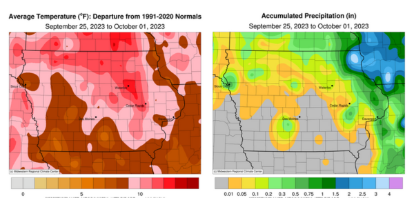
Late-season warmth persisted across Iowa during the reporting period with positive departure approaching 12 degrees over portions of northern Iowa; the statewide average temperature was 69.1 degrees, 9.6 degrees above normal. A quiet storm track also limited rainfall over much of the state with many stations reporting no measurable totals.
Clouds gradually decreased through Sunday (24th) afternoon with westerly winds and highs in the upper 70s and low 80s. Thunderstorms formed in eastern Iowa after sunset but quickly dissipated by midnight; several stations in Dubuque County reported more than 0.50 inch with 0.56 inch near Dubuque to 2.40 inches in Peosta. Winds died down into Monday (25th) morning as lows bottomed out in the 50s with patchy fog in northern Iowa. Another wave of showers and thunderstorms associated with a cut-off low in Minnesota pushed into northern and eastern Iowa during the evening hours; a more concentrated cluster re-fired in the northeast corner towards daybreak on Tuesday (26th). Scattered thundershowers continued on the backside of the low-pressure center for most of the day as high temperatures remained seasonal in the upper 60s to low 70s over most of Iowa. Showers and thunderstorms finally dissipated during the nighttime hours with rainfall total highest in the northeast; Decorah (Winneshiek County) measured 1.05 inches while Waukon (Allamakee County) reported 3.93 inches. Almost 60 stations farther west observed at least 0.20 inch with a statewide average of 0.15 inch. Ample low-level moisture allowed dense fog to form before sunrise on Wednesday (27th) before burning off as the sun heated the surface through late morning. Afternoon temperatures hovered in the low to mid 70s under partly cloudy skies and variable winds. Light and spotty showers dotted northeastern Iowa during the evening hours as winds shifted to the east; Waukon recorded an additional 0.35-inch total.
Fog formed across Iowa’s eastern three-quarters into Thursday (28th) with morning temperatures in the upper 50s and low 60s. Winds shifted to the southeast through the day with afternoon temperatures from the upper 60s northeast to mid-80s southwest. Starry skies held into Friday (29th) with lows in the 60s over western Iowa; conditions in eastern Iowa were several degrees cooler with patchy fog. Gusty southerly winds pushed highs into the low to mid 90s in western Iowa as low to mid 80s were observed east. Isolated severe-warned thunderstorms fired in extreme northwestern Iowa, leaving behind 0.90 inch of rainfall in Sioux City (Woodbury County). Saturday (30th) was an unseasonably hot day across Iowa with highs in the 90s statewide under sunny skies; the statewide average high was 92 degrees, 22 degrees above normal. Light southeasterly winds continued into Sunday (1st) morning with clear skies and lows ranging from the mid-60s east to mid-70s west.
Weekly precipitation totals ranged from no accumulation across much of Iowa to 4.28 inches in Waukon. The statewide weekly average precipitation was 0.21 inch while the normal is 0.70 inch. Little Sioux (Harrison County) reported the week’s high temperature of 97 degrees on the 30th, 25 degrees above normal. Audubon (Audubon County) reported the week’s low temperature of 44 degrees on the 29th, a tenth of a degree below normal.
