Iowa Crop Progress and Condition Report
March 27 - April 2, 2023
DES MOINES, Iowa (April 3, 2023) – Iowa Secretary of Agriculture Mike Naig commented today on the Iowa Crop Progress and Condition Report released by the USDA National Agricultural Statistics Service. The report is released weekly April through November. Additionally, the Iowa Department of Agriculture and Land Stewardship provides a weather summary each week during this time.
“An active end to March brought beneficial precipitation to much of Iowa but also a severe weather outbreak with multiple destructive tornadoes in eastern Iowa,” said Secretary Naig. “As farmers look ahead to spring field work, the longer-term April outlook is indicating that we could see above-average precipitation for the month with drier short-term conditions to start.”
The weekly report is also available on the USDA’s website at nass.usda.gov.
Crop Report
Colder than normal temperatures for the week left Iowa farmers with 1.6 days suitable for fieldwork during the week ending April 2, 2023, according to the USDA, National Agricultural Statistics Service. Parts of the State still reported frost in the topsoil, while select counties in southern and eastern Iowa experienced hail and tornadoes. Although minimal fieldwork occurred over the last week, some producers were able to apply anhydrous, manure, and dry fertilizer. A few instances of oat seeding were reported.
Topsoil moisture condition rated 2 percent very short, 15 percent short, 76 percent adequate and 7 percent surplus. Subsoil moisture condition rated 6 percent very short, 25 percent short, 64 percent adequate and 5 percent surplus.
Feedlots were drying out and calving continued. Overall livestock were faring well, although there were reports of livestock injuries from the severe weather in isolated areas.
Weather Summary
Provided by Justin Glisan, Ph.D., State Climatologist, Iowa Department of Agriculture and Land Stewardship
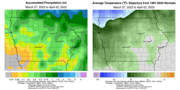
March ended like a lion with widespread severe thunderstorms as well as a tornado outbreak across several states, including at least 10 in Iowa. Widespread rainfall was reported with these storms along with additional moisture from early week snow and rain; much of Iowa reported near to slightly below-average totals. Temperatures during the first reporting period of 2023 were up to 12 degrees below normal in the northwest with a statewide average temperature of 38.2 degrees, 5.1 degrees below normal.
A narrow band of snow continued to move from central to eastern Iowa through Sunday (26th) afternoon. Snow totals ranged from 0.1 inch at Creston (Union County) to 5.6 inches in Jefferson (Greene County). Daytime highs hovered in the mid to upper 30s as skies cleared and winds shifted to a northerly direction. Overnight lows varied from the upper teens west to the upper 20s east. Monday (27th) was a quiet weather day with clear skies and light, variable winds. Afternoon highs were cooler than average, ranging from the mid 30s northwest to the low 50s southeast. Cloud cover increased over southern Iowa through the morning hours on Tuesday (28th) with pockets of light snow. Morning lows held in the upper 20s and low 30s under cloud cover while teens were observed farther north. Winds shifted to the west and became blustery throughout the day with temperatures climbing into the mid to upper 40s under clear skies. Clouds filtered in overnight as light snow fell over a swath of northern Iowa before sunrise on Wednesday (29th). Sunny skies prevailed with winds turning to an easterly direction as temperatures climbed into the 40s in southern Iowa with readings up to 10 degrees cooler north. Thursday (30th) was a transition day across the Midwest as gusty southerly winds transported warmer temperatures and anomalous low-level moisture into southern Iowa. Daytime temperatures pushed into the upper 60s south while readings north of the warm front were in the upper 40s and low 50s.
Showers and thunderstorms formed overnight into Friday (31st) in advance of a potent low pressure system pushing across Nebraska. As atmospheric instability increased over the daytime hours, highs climbed into the upper 70s and low 80s in central Iowa. Severe thunderstorms, initially discrete supercells, fired along a dry line as the low pressure marched through Iowa. Thunderstorms eventually consolidated into a line that sped into eastern Iowa at over 50 miles per hour. Several storms spawned tornadoes rated EF-2 with a strong EF-4 moving northeast through sections of Keokuk, Washington and Johnson counties. Keota (Keokuk County) experienced wind speeds up to 170 mph with widespread structural damage. A second line of severe storms formed along the low’s attendant cold front, producing several reports of severe hail and straight-line winds. The powerful system cleared Iowa as strong northwesterly winds built in, ushering in a colder airmass and light snow. Event precipitation totals reported at 7:00 am on Saturday (1st) were highest in eastern Iowa with nearly 40 stations measuring at least 0.50 inch; Elma (Howard County) observed 1.48 inches. Afternoon temperatures rebounded into the upper 40s and low 50s under sunny skies. Winds shifted to a southerly direction overnight with scattered clouds and temperatures remaining in the 30s on Sunday (2nd) morning.
Weekly precipitation totals ranged from no accumulation in southwest Iowa to 1.82 inches at Le Claire Lock and Dam (Scott County). The statewide weekly average precipitation was 0.42 inches while the normal is 0.68 inch. Ames Municipal Airport (Story County) reported the week’s high temperature of 81 degrees on the 31st, 26 degrees above average. Multiple northwest stations reported the week’s low temperature of 10 degrees from the 28th to the 30th, on average 18 degrees below normal. Four-inch soil temperatures were in the mid to upper 30s northwest to upper 40s south as of Sunday.
