Iowa Crop Progress and Condition Report
Oct. 16-22, 2023
DES MOINES, Iowa (Oct. 23, 2023) – Iowa Secretary of Agriculture Mike Naig commented on the Iowa Crop Progress and Condition Report released by the USDA National Agricultural Statistics Service. The report is released weekly April through November. Additionally, the Iowa Department of Agriculture and Land Stewardship provides a weather summary each week during this time.
“Warmer and generally dry conditions allowed for harvest to take another big step forward, with soybeans nearing completion,” said Secretary Naig. “A significant weather system with the potential for widespread rain is expected to move through the state later this week, which could idle harvest but alleviate some of the drought conditions.”
The weekly report is also available on the USDA’s website at nass.usda.gov.
Crop Report
Dry and warmer than normal temperatures in Iowa this week resulted in 5.7 days suitable for fieldwork during the week ending October 22, 2023, according to the USDA, National Agricultural Statistics Service. Corn and soybean harvest continued to be the primary field activities for the week, although there were reports of fertilizer application and fall tillage.
Topsoil moisture condition rated 16 percent very short, 38 percent short, 44 percent adequate and 2 percent surplus. Subsoil moisture condition rated 28 percent very short, 43 percent short, 28 percent adequate and 1 percent surplus.
Corn harvested for grain reached 62 percent statewide, 2 days ahead of last year and 1 week ahead of the 5-year average. Moisture content of field corn being harvested for grain remained steady at 17 percent. Soybeans harvested reached 87 percent, 1 day ahead of last year and 10 days ahead of the average.
Pasture condition improved slightly to 19 percent good to excellent. Livestock conditions have been reported as generally good, while getting water to pastured cattle continued to be an issue.
Weather Summary
Provided by Justin Glisan, Ph.D., State Climatologist, Iowa Department of Agriculture and Land Stewardship
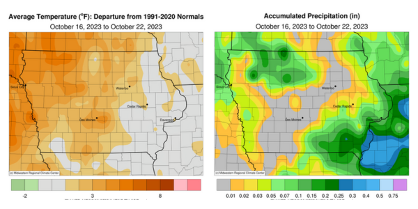
Temperatures through the reporting period were unseasonably warm across much of Iowa with positive departures up to four degrees in the northwest; the statewide average temperature was 52.0 degrees, 2.2 degrees above normal. Rainfall was also sparse with widespread deficits in the 0.40- to 0.60-inch range along with numerous stations reporting no measurable totals.
Clouds cleared in northeastern Iowa through Sunday (15th) afternoon as overcast conditions and spotty light showers remained in southern Iowa. Brisk northwesterly winds held daytime temperatures in the low to mid-50s. The remaining cloud cover over the state quickly dissipated, leading to starry skies into Monday (16th) with morning lows in the upper 30s and low 40s. High temperatures varied from the upper 50s north to mid-60s south under sunny skies with northwesterly winds persisting. Calm to light and variable winds developed overnight with patchy fog across northeastern Iowa and morning lows on Tuesday (17th) in the 30s. Afternoon conditions were clear with southwesterly winds and high temperatures in the upper 60s and low 70s. Winds began shifting to the west as a low-pressure center propagated through Minnesota into Wednesday (18th) with morning lows holding in the 30s east to low 50s west. Light showers formed along the attendant cold front as it swept through the state in the late afternoon with temperatures holding in the upper 50s and low 60s. Additional showers formed in northwestern Iowa and then reformed over southeastern Iowa before dissipating near sunrise on Thursday (19th). Rainfall totals were widespread, though generally less than 0.20 inch; the highest amounts were found in north-central and southeastern Iowa with 0.32 inch in Swea City (Kossuth County), 0.34 inch in Wapello (Louisa County) and 0.40 inch at Keokuk Lock and Dam (Lee County).
Clouds gradually cleared in western Iowa later in the day with highs climbing into the upper 60s, while mid to upper 50s persisted under overcast skies. Light westerly winds persisted into Friday (20th) with morning lows in the upper 30s to mid-40s with patchy fog observed in central Iowa. Mostly sunny skies greeted Iowa through the day with highs varying from the mid-60s east to upper 70s west, where winds were out of the south; the statewide average high was 71 degrees, 10 degrees above normal. A weak and fast-moving cold front dropped southeast through Iowa into Saturday (21st), shifting winds to the northwest. Wind speeds increased as the sun rose with skies remaining clear and temperatures rising into the upper 50s and low 60s. Morning lows on Sunday (22nd) ranged from the mid-30s northwest to mid-40s southeast under clear skies and light winds.
Weekly precipitation totals ranged from no accumulation at stations across Iowa to 0.41 inch in Oskaloosa (Mahaska County). The statewide weekly average precipitation was 0.10 inch while the normal is 0.58 inch. Little Sioux (Harrison County) reported the week’s high temperature of 80 degrees on the 20th, 19 degrees above normal. Elkader (Clayton County) and Stanley (Buchanan County) reported the week’s low temperature of 28 degrees on the 18th, on average eight degrees below normal.