Iowa Crop Progress and Condition Report
May 29 - June 4, 2023
DES MOINES, Iowa (June 5, 2023) — Iowa Secretary of Agriculture Mike Naig commented today on the Iowa Crop Progress and Condition Report released by the USDA National Agricultural Statistics Service. The report is released weekly April through November. Additionally, the Iowa Department of Agriculture and Land Stewardship provides a weather summary each week during this time.
“In between spotty thunderstorms last week, farmers took advantage of the opportunity to begin applying crop protection products, adding side-dress fertilizer, and cutting and baling hay,” said Iowa Secretary of Agriculture Mike Naig. “Widespread rain totals were below average and much of the state remains abnormally dry, but forecasts do indicate chances for precipitation and a return to more seasonal temperatures.”
The weekly report is also available on the USDA’s website at nass.usda.gov.
Crop Report
Isolated rain showers during the week led to 5.8 days suitable for fieldwork during the week ending June 4, 2023, according to the USDA, National Agricultural Statistics Service. Farmers were still planting some corn and soybeans this week, however nearly all planting activities are finished. There were limited reports of crop replanting in certain fields. Other field activities included cutting hay and spraying emerging crops.
Topsoil moisture condition rated 13 percent very short, 42 percent short, 44 percent adequate and 1 percent surplus. Subsoil moisture condition rated 12 percent very short, 41 percent short, 46 percent adequate and 1 percent surplus.
Corn emergence reached 94 percent, 1 week ahead of last year and 8 days ahead of the 5-year average. Corn condition declined 5 percentage points to 72 percent good to excellent. Ninety-eight percent of Iowa’s expected soybean crop has been planted, 10 days ahead of last year and 2 weeks ahead of normal. Eighty-seven percent of soybeans have emerged, 10 days ahead of last year and 12 days ahead of the average. Soybean condition rated 70 percent good to excellent. Thirty-eight percent of the oat crop has headed, 8 days ahead of last year and the average. Oat condition declined to 70 percent good to excellent.
Seventy-eight percent of the State’s first cutting of alfalfa hay has been completed, 12 days ahead of the 5-year average. Hay condition fell 6 percentage points to 52 percent good to excellent. Pasture condition dropped to 42 percent good to excellent. Some livestock producers have already had to feed hay due to drying pastures.
Weather Summary
Provided by Justin Glisan, Ph.D., State Climatologist, Iowa Department of Agriculture and Land Stewardship
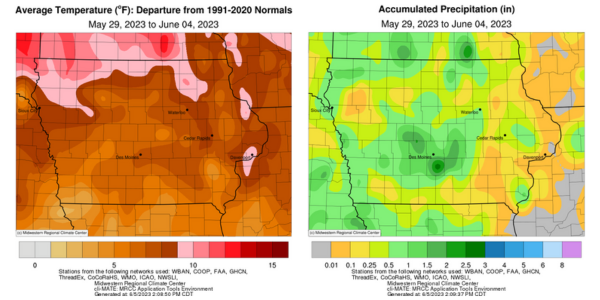
A large-scale high-pressure system over Canada produced anomalous southeasterly to easterly flow across Iowa towards the end of the reporting period. Widely scattered pop-up thunderstorms also formed over portions of Iowa on several days, though rainfall was below average. Unseasonably warm conditions continued with positive departures of up to 12 degrees in northwest Iowa; the statewide average temperature was 73.7 degrees, 8.3 degrees above normal.
Sunshine and southeasterly winds continued through Sunday (28th) afternoon with daytime temperatures in the low 80s statewide. Clouds increased in southwestern Iowa overnight as scattered showers formed near sunrise on Monday (29th) before dissipating in west-central Iowa by mid-morning. Partly cloudy skies remained in western Iowa with afternoon highs in the mid to upper 80s at many stations. A disturbance moving across the Dakotas produced isolated thunderstorms over northwestern and north-central Iowa late in the day and through the early morning hours of Tuesday (30th). Only a handful of stations observed rainfall totals above 0.10 inch though Mapleton (Monona County) measured 0.78 inch. Storms refired in western Iowa as temperatures pushed into the upper 80s with southerly flow. Many stations observed 0.25 to 0.50-inch totals with slower moving thunderstorms dropping 3.13 inches and 3.66 inches at two stations in Fort Dodge (Webster County); 20 stations reported at least an inch. Wednesday (31st) morning lows remained in the 60s with light showers over northern Iowa. Afternoon thunderstorms popped up in northwestern Iowa with locally heavy rainfall and flash flooding in O’Brien County; Sheldon measured 1.34 inches with a half-inch total at Rock Rapids (Lyon County). Pockets of showers and thunderstorms formed from southwest to central Iowa into Thursday (1st) morning with afternoon heat producing scattered pop-up storms across the state several hours later.
Partly to mostly cloudy skies persisted into Friday (2nd) as temperatures rose into the upper 80s at many stations. In the presence of ample low-level moisture and instability, afternoon thunderstorms again fired over much of Iowa. Most of the thunderstorm activity fizzled out around sunset with rain showers remaining in western Iowa. Rain totals over the previous 48 hours were above 0.30 inch at most stations receiving rainfall with Atlantic (Cass County) and Little Sioux (Harrison County) reporting 2.09 and 2.30 inches, respectively. Saturday (3rd) was generally quiet across Iowa with daytime conditions in the upper 80s and low 90s at southern and eastern stations; the statewide average high was 89 degrees, 12 degrees above normal. Easterly flow pushed scattered thundershowers across northern Iowa during the afternoon hours; Rock Valley (Sioux County) reported 1.24 inches while Swea City (Kossuth County) picked up 1.45 inches. Skies remained mostly clear into Sunday (4th) with unseasonably warm morning temperatures in the mid to upper 60s, up to 10 degrees above average.
Weekly rain totals ranged from no accumulation at eastern Iowa stations to 3.93 inches in St. Charles (Madison County). The statewide weekly average precipitation was 0.64 inch, while the normal is 0.97 inch. Dubuque Lock and Dam (Dubuque County) reported the week’s high temperature of 94 degrees on the 3rd, 16 degrees above normal. Anamosa (Jones County) and Centerville (Appanoose County) reported the week’s low temperature of 43 degrees on the 29th, on average 10 degrees below normal.