Iowa Crop Progress and Condition Report for April 26 – May 2, 2021
DES MOINES, Iowa (May 3, 2021) — Iowa Secretary of Agriculture Mike Naig today commented on the Iowa Crop Progress and Condition report released by the USDA National Agricultural Statistics Service. The report is released weekly from April through November.
“The weather over the past several days provided a great window for farmers to plant,” said Secretary Naig. “Now we need some rain, especially in the northern parts of the state, to help push the crop along. Short-term outlooks are promising with the potential for cooler and wetter days ahead.”
The weekly report is also available on the USDA’s website at nass.usda.gov.
Crop Report
Planting of corn and soybean crops accelerated during the week ending May 2, 2021 according to the USDA, National Agricultural Statistics Service. Statewide there were 6.3 days suitable for fieldwork for the week due to limited precipitation. Other field activities such as applying anhydrous and dry fertilizer were sporadic, due to strong winds.
Topsoil moisture levels rated 17% very short, 38% short, 45% adequate and 0% surplus. Subsoil moisture levels rated 14% very short, 44% short, 42% adequate and 0% surplus. Dry conditions are a concern. Iowa farmers were able to plant almost half of the State’s expected corn crop during the week ending May 2 for a total of 69% planted, 9 days ahead of the 5-year average. With the week’s warmer temperatures, there were scattered reports of corn emerged.
Iowa farmers planted over one-third of the expected soybean crop during the week ending May 2 for a total of 43% planted, 12 days ahead of normal. Ninety-five percent of Iowa’s expected oat crop has been planted, 2 days ahead of last year and 10 days ahead of the 5-year average. Statewide 51% of the oat crop has emerged, 3 days ahead of average.
Pasture condition rated 41% good to excellent. Reports were received of slow growth due to lack of moisture. No livestock problems were reported.
Weather Summary
Provided by Justin Glisan, Ph.D., State Climatologist, Iowa Department of Agriculture and Land Stewardship
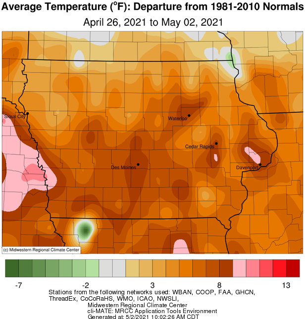
Unseasonably dry conditions persisted across Iowa during the reporting period with departures nearing an inch below average at multiple stations statewide. Only portions of extreme southeast Iowa reported above-average rainfall. Warm and windy conditions were also observed on multiple days with parts of western Iowa experiencing temperatures up to 10 degrees warmer than normal; the statewide average temperature was 62.0 degrees, 8.0 degrees above normal.
A disturbance moving through the Midwest brought showers across northern Iowa in the late morning hours on Sunday (25th) with rain exiting eastern Iowa in the evening. Strong southeasterly winds built-in as a low pressure system approached from the west. Rain totals reported at 7 a.m. on Monday (26th) were highest in the northwestern corner with Sanborn (O’Brien) and Spirit Lake (Dickinson) observing 0.35 inch; totals tailed off south and east where rain gauges collected a few tenths of an inch. With a strong southerly wind persisting under mostly sunny skies, afternoon highs pushed into the mid to upper 80s in southwestern Iowa while cloud cover held temperatures in the 60s and 70s over northern Iowa. Morning lows on Tuesday (27th) remained unseasonably warm over the state’s southern half, generally in the low to mid 60s with upper 40s under cloud cover towards the Iowa-Minnesota border. A center of low pressure pushing through Iowa shifted winds to a northerly direction from the west to east during the day leading to quite a range of temperatures; low 50s were reported behind the low in northwestern Iowa and low to mid 80s behind the warm front in southern Iowa. Showers formed across western Iowa as the disturbance propagated over the region. Showers and a few thunderstorms continue to pop up through most of Wednesday (28th), leading to higher totals in southeastern Iowa as the system moved east. Event rain totals reported at 7 a.m. Thursday (29th) were highest in the state’s southeast corner with over 20 rain gauges collecting an inch or more of new rainfall; several stations in Appanoose, Davis and Lee counties observed more than 1.50 inches.
Behind the system, skies began to clear with a light northerly breeze and near-seasonal afternoon highs in the low to mid 70s. Skies remained generally clear with a few cumulus clouds passing through northern Iowa as the moon set Friday (30th) morning. Temperatures climbed back into the 70s with variable winds, leading to a very pleasant day statewide. Overnight lows into Saturday (1st) remained warm, ranging from the mid 50s south to low 60s north. Blustery winds out of the southwest and clear skies led to the warmest temperatures of the season with mid to upper 90s in northern Iowa and mid 80s in southern Iowa; the statewide average high was 87 degrees, 20 degrees above normal. As the sun set, winds gradually died down under starry skies into Sunday (2nd) morning with observed lows in the upper 50s and low 60s.
Weekly precipitation totals ranged from no accumulation at several stations across Iowa to 1.72 inches at Rathbun Dam (Appanoose County). The statewide weekly average precipitation was 0.18 inch while the normal is 0.89 inch. Spencer Municipal Airport (Clay County) reported the week’s high temperature of 97 degrees on the 1st, 31 degrees above average. Elkader (Clayton County) reported the week’s low temperature of 24 degrees on the 26th, 15 degrees below normal. Four-inch soil temperatures were in the low to mid 60s statewide as of Sunday.
 |
 |