Iowa Crop Progress and Condition Report
June 12 - June 18, 2023
DES MOINES, Iowa (June 20, 2023) — Iowa Secretary of Agriculture Mike Naig commented today on the Iowa Crop Progress and Condition Report released by the USDA National Agricultural Statistics Service. The report is released weekly April through November. Additionally, the Iowa Department of Agriculture and Land Stewardship provides a weather summary each week during this time.
“As drought and abnormally dry conditions continue across Iowa, widespread weekend rainfall throughout most of the state was welcomed by farmers,” said Secretary Mike Naig. “While scattered storms are possible this weekend, the official start to summer this week will coincide with a stretch of hot and dry days. Longer term outlooks are showing a return to near-normal rainfall as we enter a critical period for crop growth.”
The weekly report is also available on the USDA’s website at nass.usda.gov.
Crop Report
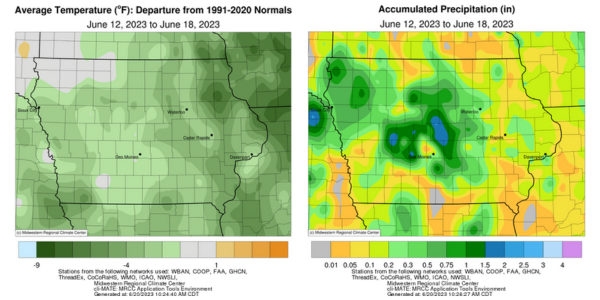
Below average precipitation for the week gave Iowa farmers 6.3 days suitable for fieldwork during the week ending June 18, 2023, according to the USDA, National Agricultural Statistics Service. Field activities included cutting hay and spraying crops. Drought concerns were still prominent.
Topsoil moisture condition rated 20 percent very short, 50 percent short, 30 percent adequate and 0 percent surplus. The percentage of topsoil moisture considered short to very short has gone from 25 percent the week ending May 21, 2023, to 70 percent for the week ending June 18, 2023, just 1 month later. Subsoil moisture condition rated 17 percent very short, 47 percent short, 35 percent adequate and 1 percent surplus.
Corn condition continued to decline rating 59 percent good to excellent. Ninety-eight percent of soybeans have emerged, 10 days ahead of last year and 2 weeks ahead of the 5-year average. Soybean condition dropped to 56 percent good to excellent. Eighty-four percent of the oat crop has headed, 11 days ahead of last year and the average. Ten percent of oats were turning color, 1 week ahead of last year and normal. Oat condition declined to 50 percent good to excellent.
Ninety-six percent of the State’s first cutting of alfalfa hay has been completed and the second cutting has started with 6 percent complete, roughly 1 week ahead of last year and the average. Hay condition declined to 36 percent good to excellent. Pasture condition rated just 28 percent good to excellent. Livestock producers have started to supplement with hay as pasture conditions continued to decline. Reports were also received of concerns with water supply as some ponds and creeks have been going dry.
Weather Summary
Provided by Justin Glisan, Ph.D., State Climatologist, Iowa Department of Agriculture and Land Stewardship
Just under half of the climatological expected rain fell across Iowa over the reporting period with deficits approaching two inches in portions of northeastern and southern Iowa. Cooler conditions were also reported with departures of up to five degrees below normal in northeast Iowa; the statewide average temperature was 67.9 degrees, 2.7 degrees below normal.
Overcast skies persisted through Sunday (11th) afternoon as gusty northerly winds held temperatures in the upper 50s north to mid-60s south. Rain showers also dissipated across southwestern and eastern Iowa with Rathbun Dam (Appanoose County) collecting 0.28 inch while Bedford (Taylor County) measured 0.40 inch. Overnight lows on Monday (12th) were unseasonably cold with departures of up to 20 degrees in northeast Iowa producing patchy frost and isolated crop damage; temperatures dipped into the mid-30s and 40s with a statewide average low of 44 degrees, 15 degrees below normal. Winds were westerly early on, shifting to northwesterly with mostly sunny skies and daytime highs in the 70s. Scattered showers spun through eastern Iowa during the evening and continued into Tuesday (13th) morning with amounts generally under 0.10 inch where rain was observed. Partly cloudy skies remained through the day with comfortable afternoon temperatures in the low 80s. Variable winds developed on Wednesday (14th) with mostly clear skies and highs reaching into the mid- to upper 80s with low relative humidity. Hazy conditions were reported after sunrise on Thursday (15th) as Canadian wildfire smoke returned to the Upper Midwest, leading to widespread air quality issues. Afternoon temperatures approached the 90s at several locations in western Iowa with low 80s in eastern Iowa.
Upper-level haze continued overnight into Friday (16th) as easterly winds built in with temperatures ranging from the mid-40s northeast to low 60s southwest. Afternoon conditions were pleasant across Iowa’s eastern two-thirds with highs in the mid-70s and sunny skies. Spotty thundershowers popped up just over the border in Nebraska with a few cells lingering in western Iowa before dissipating near sunset. Partly cloudy skies remained across western Iowa into Saturday (17th) as winds shifted to a southerly direction. Morning temperatures were in the low 60s under clouds while in the low to mid-50s in eastern Iowa where clear skies were present. Afternoon temperatures rose into the upper 70s and low 80s as a low-pressure center approached from the southwest. Thunderstorms formed in west-central Iowa in the late afternoon and sped east over the next several hours. A few cells became severe-warned with a handful of large hail and high wind reports; Creston (Union County) observed one-inch diameter hail with a 60-mph wind gust reported at the airport. The initial thunderstorms consolidated into a non-severe line with moderate to heavy rain falling across central Iowa. More than 25 stations observed at least an inch with seven stations reporting more than two inches; Boone (Boone County) measured 2.02 inches while Coon Rapids (Carroll County) observed 2.30 inches. Most of Iowa’s stations reported rain with general amounts outside of central Iowa in the 0.20 to 0.75-inch range. Foggy conditions developed as the system pulled out of eastern Iowa on Sunday (18th) morning with overcast skies and lows in the low to mid-60s.
Weekly rain totals ranged from no accumulation at multiple stations to 2.60 inches in Story City (Story County). The statewide weekly average precipitation was 0.54 inch, while the normal is 1.19 inches. Spencer Municipal Airport (Clay County) reported the week’s high temperature of 92 degrees on the 15th, 11 degrees above normal. Elkader (Clayton County) reported the week’s low temperature of 35 degrees on the 12th, 20 degrees below normal.