Iowa Crop Progress and Condition Report
May 3 - 9, 2021
DES MOINES, Iowa (May 10, 2021) — Iowa Secretary of Agriculture Mike Naig today commented on the Iowa Crop Progress and Condition report released by the USDA National Agricultural Statistics Service. The report is released weekly from April through November.
“Many farmers across Iowa were grateful for the much-needed rainfall we received over the weekend,” said Secretary Naig. “With cooler and drier conditions for much of last week, farmers made significant planting progress and are ahead of schedule this year.”
The weekly report is also available on the USDA’s website at nass.usda.gov.
Crop Report
Much needed precipitation across much of Iowa was beneficial to crop progress during the week ending May 9, 2021 according to the USDA, National Agricultural Statistics Service. Statewide there were 5.1 days suitable for fieldwork for the week due to precipitation. Other field activities such as spraying and applying anhydrous and dry fertilizer were slowed by sporadic rains.
Topsoil moisture levels rated 10% very short, 27% short, 61% adequate and 2% surplus. Subsoil moisture levels rated 13% very short, 39% short, 46% adequate and 2% surplus.
Statewide, 86% of the expected corn crop has been planted, 10 days ahead of the 5-year average. North central and central Iowa farmers have less than 10% of their expected corn crop remaining to be planted. Corn emergence improved to 22% complete, an increase of 20 percentage points from the previous week. Just over two-thirds of the expected soybean crop has been planted, 15 days ahead of the five-year average. Six percent of the expected soybean crop has emerged, 5 days ahead of normal. Seeding of Iowa’s expected oat crop is nearly complete with 74% emerged, 4 days ahead of average. Iowa’s first oat crop condition rating of the season was 2% very poor, 4% poor, 36% fair, 51% good and 7% excellent.
The first hay condition rating of the season was 4% very poor, 7% poor, 31% fair, 51% good and 7% excellent. There were reports of some farmers starting their first cutting of alfalfa. Pasture condition rated 42% good to excellent. Rain during the week helped green up some pastures. Livestock were reported to be in good condition, especially in terms of calving.
Weather Summary
Provided by Justin Glisan, Ph.D., State Climatologist, Iowa Department of Agriculture and Land Stewardship
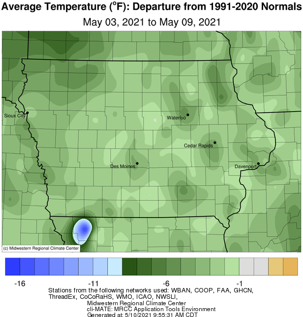
A stubborn atmospheric pattern had the jet stream dipping farther south than usual for early May, keeping cooler conditions statewide. Northwest Iowa observed negative departures over six degrees with the statewide average temperature at 51.7 degrees, 5.5 degrees below normal. After persistent dryness for the last several weeks, a more active storm track brought much-needed rain across most of Iowa with above-average totals reported in portions of western, north-central and southeastern Iowa.
Winds shifted to a southerly direction through Sunday (2nd) afternoon in advance of a low pressure system. Under mostly sunny skies, daytime highs reached into the 80s, marking the warmest day of the reporting period; the statewide average high was 82 degrees, 16 degrees above normal. The low pushed into northern Iowa overnight into Monday (3rd), firing off some stronger thunderstorms along the attendant cold front in western Iowa. Showers and thunderstorms filled in across Iowa’s western half in the early morning hours before dissipating towards sunrise. As the front moved into eastern Iowa, rain reformed with locally heavier amounts from thunderstorms in southwestern Iowa. Cooler air filtered in behind the low pressure center as winds shifted out of the north under clearing skies. Morning lows reported at 7:00 am on Tuesday (4th) ranged from the upper 30s north to upper 40s south. Except for extreme northwest Iowa, measurable rain fell statewide with the highest totals found in a band from west-central to northeastern Iowa and over the southeastern corner; generally above 0.50 inch with lesser totals in between. Several stations in Harrison and Monona counties measured above two inches; a rain gauge near Cresco (Winneshiek County) collected 3.00 inches. Daytime temperatures remained in the low 60s under sunny skies. Winds died down into Wednesday (5th) morning, allowing temperatures to dip below freezing across western Iowa; conditions were warmer in eastern Iowa where low to mid 40s were observed. Cloud cover began to increase through the day as another disturbance brought light rain showers in northern and western sections of the state, though widespread totals were under a few tenths of an inch.
The low pressure center pushed out of eastern Iowa early Thursday (6th) with afternoon highs in the low 60s under partly cloudy skies. Winds shifted to a northerly direction from south-westerlies and then to a pure easterly flow as a weak cold front dropped through Iowa early Friday (7th). As the front moved south, temperatures remained in the upper 50s north to upper 60s south as stations were still in a warmer air mass. Cloud cover began to increase as a strong low pressure system propagated towards western Iowa into Saturday (8th) with rain showers and some thunderstorms moving over the state’s northern half. As the low center approached northern Missouri, a shield of moderate to heavy rain filled in across southern Iowa through the overnight hours into Sunday (9th) with 24-hour totals highest across southern sections of the state. Nearly 70 stations reported an inch or more with Washington (Washington County) measuring 2.00 inches while Columbia (Marion County) observed 2.60 inches; the statewide average rainfall was 0.88 inches with only a handful of northeastern Iowa stations reporting no rain.
Weekly precipitation totals ranged from 0.22 inch in Swea City (Kossuth County) to 4.13 inches at Little Sioux (Harrison County). The statewide weekly average precipitation was 1.48 inches while the normal is 0.95 inch. Multiple National Weather Service co-op stations observed the week’s high temperature of 87 degrees on the 2nd (reported on the 3rd), on average 21 degrees above normal. Atlantic (Cass County) and Guthrie Center (Guthrie County) reported the week’s low temperature of 27 degrees on the 5th, on average 17 degrees below normal. Four-inch soil temperatures were in the mid 50s north to low 50s south as of Sunday.
 |
 |