Iowa Crop Progress and Conditions Report
Week of April 22-28, 2019
DES MOINES, Iowa (April 29, 2019) – Iowa Secretary of Agriculture Mike Naig today commented on the Iowa Crop Progress and Condition report released by the USDA National Agricultural Statistics Service. The report is released weekly from April through November.
“Planting season is officially underway. The report shows that 21 percent of corn and 3 percent of soybeans are in the ground. This puts us slightly ahead of last year, when 17 percent of corn and 2 percent of beans were planted by the last week in April,” said Naig. “The forecast shows that many parts of the state are going to experience wet weather this week, which will hinder progress.”
The weekly report is also available on the USDA’s site at nass.usda.gov/ia.
Crop Report
Favorable weather conditions at the beginning of the week ending April 28, 2019, allowed Iowa farmers to make planting progress according to the USDA, National Agricultural Statistics Service. However, rain and snow over the weekend created some fieldwork delays. Statewide there were 4.3 days suitable for fieldwork. Activities for the week included hauling manure, applying anhydrous, tillage and planting.
Topsoil moisture levels rated 0 percent very short, 1 percent short, 74 percent adequate and 25 percent surplus. Subsoil moisture levels rated 0 percent very short, 1 percent short, 66 percent adequate and 33 percent surplus.
Iowa farmers have planted 21 percent of the expected corn crop, 2 days ahead of last year but 2 days behind the 5-year average. Central, south central, and southeast Iowa farmers already have at least one-third of their corn planted. Soybean planting has started with 3 percent of the expected crop in the ground, similar to last year and the average. Seventy-seven percent of the expected oat crop has been planted, over one week ahead of last year but equal to the average. Fourteen percent of the crop has emerged, 8 days behind average.
Pasture Condition rated 3 percent very poor, 6 percent poor, 35 percent fair, 46 percent good and 10 percent excellent. Pasture growth has been slow in much of the State. Feedlot conditions have improved.
Preliminary Weather Summary
Provided by Justin Glisan, Ph.D., State Climatologist, Iowa Department of Agriculture and Land Stewardship
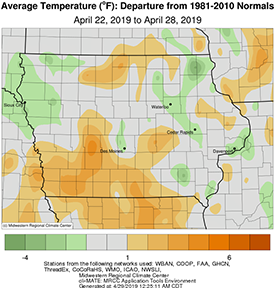
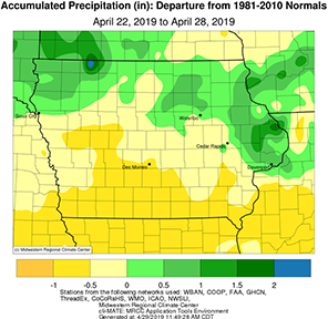
The last full week of April experienced wetter than average conditions across parts of northern and eastern Iowa, and near to drier than average conditions moving south. Temperatures also varied across the state with southern Iowa a few degrees warmer than average; the rest of Iowa was near normal.
A low pressure center spun through Iowa on Monday (22nd), leaving measurable rainfall across much of the state’s northern half. Rainfall totals were generally in the range of 0.20 – 0.60 inches with a few stations reporting over an inch; Bellevue Lock and Dam (Jackson County) reported 1.37 inches of rain, 1.25 inches above average. A strong attendant cold front produced severe thunderstorms as it moved through eastern Iowa. Severe hail was reported in Muscatine (Muscatine County). Severe straight-line winds were also reported in Linn County, causing damage to power poles and trees in Mt. Vernon. Tuesday (23rd) was mostly sunny and warm as high pressure dominated the upper Midwest. Daytime highs reached into the mid-60s. Southeastern Iowa experienced light rainfall during the morning hours on Wednesday (24th). Only a few stations reported measurable rainfall; Donnellson (Lee County) picked up 0.06 inches.
A cold front entered northwestern Iowa overnight into Thursday (25th) marking a return to a more active weather pattern through the end of the reporting period. Rain totals prior to 7:00 am on Thursday ranged from 0.18 inches in Sheldon (O’Brien County) to 0.70 in Rock Rapids (Lyon County). As the front moved through the state, measurable rain fell across much of Iowa with heavier amounts in the northwest and southeast; Salem (Henry County) reported 0.45 inches. Friday (26th) began clear and cooler with cloud cover and spotty rain showers moving into western Iowa ahead of the next system to impact Iowa. This late season storm brought snow across northern Iowa with the northeast receiving amounts between two to five inches; Dubuque (Dubuque County) reported five inches. Much of Iowa also received measurable rainfall, generally between 0.20 to 0.50 inches. Overnight lows were below freezing for the northern two-thirds of Iowa. Sunday (28th) was cold statewide with daytime highs in the upper 40s north to mid-50s south, 10 – 20 degrees below average.
Temperatures for the week averaged 53.0 degrees or 0.8 degrees cooler than normal. The statewide average precipitation was 0.73 inches while normal for the week is 0.94 inches. The week’s high temperature of 79 degrees was observed in Spencer (Clay County) and Sioux City (Woodbury County) on the 24th, on average 14 degrees warmer than average. Stanley (Buchanan County) reported the week’s low temperature of 22 degrees on the 28th, 18 degrees below average. Maquoketa (Jackson County) reported the week’s highest precipitation total of 2.31 inches, 1.53 inches above average.