Iowa Crop Progress and Conditions Report
Week of July 29-August 4, 2019
DES MOINES, Iowa (Aug. 5, 2019) – Iowa Secretary of Agriculture Mike Naig today commented on the Iowa Crop Progress and Conditions report released by the USDA National Agricultural Statistics Service. The report is released weekly from April through November.
“Cooler-than-normal conditions continued across the state with varying amounts of precipitation,” said Secretary Naig. “The southwest portion of the state was the only area reporting above-average rainfall, and other areas are trending drier-than-normal.”
The weekly report is also available on the USDA’s site at nass.usda.gov/ia.
Crop Report
Another dry week across most of the State allowed Iowa farmers 6.0 days suitable for fieldwork during the week ending August 4, 2019, according to the USDA, National Agricultural Statistics Service. Fieldwork activities included moving grain, spraying fungicides and insecticides, and harvesting hay and oats.
Topsoil moisture condition was rated 5 percent very short, 26 percent short, 67 percent adequate and 2 percent surplus. Areas in 41 counties throughout Iowa were rated as abnormally dry according to the Aug. 1, 2019 U.S. Drought Monitor. Subsoil moisture condition was rated 3 percent very short, 19 percent short, 75 percent adequate and 3 percent surplus.
Eighty-four percent of the corn crop has begun to silk, 15 days behind last year and 10 days behind the 5-year average. Twenty percent of the crop reached the dough stage, 10 days behind last year and 1 week behind average. Corn condition rated 66 percent good to excellent.
Seventy-eight percent of the soybean crop has started to bloom, 15 days behind last year and 11 days behind average. Thirty-three percent of the crop has started setting pods, 16 days behind last year and 13 days behind average. Soybean condition improved slightly to 65 percent good to excellent from the previous week.
Nearly all of the oat crop has started coloring at 97 percent statewide. Sixty-four percent of the oat crop has been harvested for grain, nearly 1 week behind average. The second cutting of alfalfa hay reached 86 percent, 6 days behind average. The third cutting of alfalfa hay reached 11 percent complete statewide, 8 days behind average. Hay condition rated 61 percent good to excellent. Pasture condition continued to decline for the fifth straight week with 53 percent good to excellent. There were no major livestock issues reported this past week.
Weather Summary
Provided by Justin Glisan, Ph.D., State Climatologist, Iowa Department of Agriculture and Land Stewardship
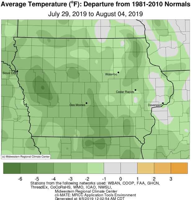
Drier than normal conditions were observed across much of Iowa with rainfall deficits between 0.50 to 1.00 inch; the southwestern part of the state reported wetter than normal conditions with some locations receiving two or more inches of rain. Cooler conditions also continued statewide with average temperatures generally one to three degrees below normal. The statewide average temperature was 70.3 degrees, 2.1 degrees below normal.
A cold front pushed through Iowa during the day on Sunday (28th) leaving behind measurable rainfall across the entire state with the heaviest amounts reported across the south and northeast. Over 40 stations reported totals at or above an inch with Clarinda (Page County) observing 2.75 inches while 2.08 inches was reported in Ackley (Butler County). The average statewide precipitation was 0.44 inches. High temperatures were held below average in western Iowa due to cloud cover, while partly cloudy skies allowed temperatures to reach into the mid to upper 80s.
Cooler air filtered in behind the front producing dry and pleasant conditions on Monday (29th). Highs were in the upper 70s and low 80s, on average three degrees cooler than normal under sunny skies and northwest winds. Rain moved into western Iowa during Tuesday (30th) afternoon while the eastern two-thirds of the state remained clear. Temperatures remained unseasonably cool across the state with west-central Iowa up to 12 degrees below normal. Thunderstorms continued to pop up and move over the same parts of western Iowa through Wednesday (31st) before moving out of southeastern Iowa during late evening.
Two-day rain totals reported at 7 a.m. Thursday (August 1st) were highest in south-central Iowa with Atlantic (Cass County) observing 1.44 inches; Holstein (Ida County) and Corning (Adams County) reported 1.23 and 1.21 inches, respectively. General totals in Iowa’s western half were between 0.25 inches to 1.00 inch. Overnight lows into Thursday were in the 50s across much of Iowa with 60s to the south; the statewide average was 58 degrees, five degrees below normal.
Mostly sunny and dry conditions persisted into Friday (2nd), though isolated showers were present across northwestern Iowa during Friday afternoon. Light rain continued into Saturday (3rd) with totals ranging from 0.01 inches in Sheldon (O’Brien County) to 0.10 inches in Akron (Plymouth County). High temperatures were in the 80s with eastern Iowa reporting some 90 degree readings. Overnight lows into Sunday (4th) were in the low 60s with foggy conditions observed across western and central Iowa.
Weekly rainfall totals ranged from 0.02 inches in Burlington (Des Moines County) and Donnellson (Lee County) to 3.31 inches in Clarinda (Page County). The statewide weekly average precipitation was 0.57 inches while the normal is 0.95 inches. The week’s high temperature of 91 degrees was reported on the 29th in Iowa City (Johnson County), five degrees above average. Cresco (Howard County) reported the week’s low temperature of 48 degrees on the 31st, 11 degrees below average.

