Iowa Crop Progress and Conditions Report
Nov. 11-17, 2019
DES MOINES, Iowa (Nov. 18, 2019) – Iowa Secretary of Agriculture Mike Naig today commented on the Iowa Crop Progress and Conditions report released by the USDA National Agricultural Statistics Service. The report is released weekly from April through November.
“Four consecutive days of favorable weather allowed many farmers to finish up soybeans last week,” said Secretary Naig. “There is still some corn in the fields, especially in northeast portions of the state which has received above-average snowfall. If we can get another stretch of dry days, many farmers will be able to wrap up harvest.”
The weekly report is also available on the USDA’s website at nass.usda.gov.
Crop Report
Snowfall in the first part of the week ending November 17, 2019 slowed down harvesting activities in parts of Iowa by limiting farmers to 4.7 days suitable for fieldwork according to the USDA, National Agricultural Statistics Service. Propane shortages continued to be a challenge for farmers across the State as they try to dry down their corn crop due to high moisture content. Fieldwork activities included harvesting corn and soybeans; baling corn stalks; applying anhydrous and fertilizer; and fall tillage.
Topsoil moisture condition was rated 0 percent very short, 2 percent short, 83 percent adequate and 15 percent surplus. Subsoil moisture condition was rated 0 percent very short, 2 percent short, 83 percent adequate and 15 percent surplus.
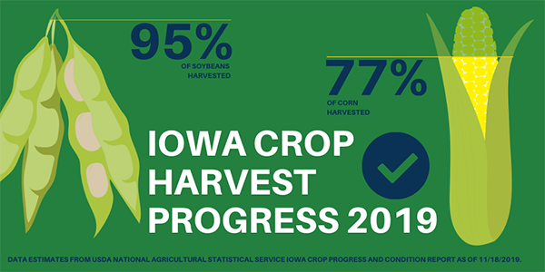
Seventy-seven percent of the corn for grain crop has been harvested, 10 days behind last year and 12 days behind the 5-year average. Producers in the Northwest and North Central Districts have harvested over 85 percent of their expected crop, while harvest in the Northeast District was just 58 percent complete. Moisture content of field corn being harvested for grain was at 20 percent.
Ninety-five percent of the soybean crop has been harvested, over 1 week behind average. The South Central and Southeast Districts still have more than 10 percent of their soybean crop remaining to be harvested.
The number of cattle grazing on corn stalks increased this past week. There were also reports that below normal temperatures and mud have been stressful on livestock.
Weather Summary
Provided by Justin Glisan, Ph.D., State Climatologist, Iowa Department of Agriculture and Land Stewardship
Drier than normal conditions persisted across Iowa for the second consecutive week with deficits of up to 0.60 inches in southern Iowa. Above average snowfall was reported across much of the state with locations in central and eastern Iowa observing up to six inches. Colder than normal conditions continued, especially in eastern Iowa where departures of up to 16 degrees below average were reported. Iowa’s average temperature was 25.1 degrees, 11.5 degrees below normal.
Snow showers moved across Iowa beginning on Sunday (10th) evening after a partly cloudy day. Daytime highs varied from the low 30s north to low 40s south with northerly winds. The system slowly moved out of southeastern Iowa by noon on Veterans Day (11th). Accumulating snow was reported statewide with a swath of two to four inches across Iowa’s central third; some stations in central and eastern Iowa reported totals over four inches with Ames (Story County) reporting 4.5 inches and Cedar Falls (Black Hawk County) reporting the highest total of 4.8 inches; the statewide average was 2.0 inches. Northerly winds and frigid temperatures were reported after the system passed with highs only reaching into the mid-teens, anywhere from 20 to 40 degrees below normal; several locations reported daytime record minimum high temperatures. A large dome of Canadian high pressure dominated the Midwest into Tuesday (12th) as temperatures plummeted, breaking more than 80 low temperature records for the date across the state. Gusty southerly winds helped daytime highs rebound slightly in southern Iowa though snowpack across central and eastern Iowa held readings in the teens.
Another fast moving system propagated through Iowa on Wednesday (13th) with a wintery mix observed in west-central Iowa and light snow reported through the evening hours across northern Iowa. The highest snow totals were reported in northeastern Iowa with Elkader (Clayton County) and Fayette (Fayette County) observing two inches. Daytime temperatures remained in the low to mid 30s. Low temperatures into Thursday (14th) morning fell into the upper teens and low 20s. Mostly sunny conditions were reported across the state through the day with highs reaching into the mid to upper 30s. Dry conditions continued into Friday (15th) with unseasonable warmth across the state’s western two-thirds. Highs reached into the mid 50s while the remaining snowpack in eastern Iowa helped hold temperatures in the 40s. The average statewide high was 50 degrees, four degrees above normal.
Warmer air over the existing snowpack led to foggy conditions into Saturday (16th) morning with overnight lows remaining above average for much of Iowa. Temperatures fell into the mid to upper 30s, up to 14 degrees warmer than normal in northwestern Iowa. Daytime highs remained unseasonably warm for the second consecutive day with southwestern Iowa reporting upper 50s. Cloud cover gradually increased through the evening hours in advance of a cold front that brought light rainfall across northwestern Iowa. Totals at 7:00 am on Sunday (17th) were generally below 0.10 inches with 0.12 inches reported in Algona (Kossuth County).
Weekly precipitation totals ranged from trace amounts at multiple stations in southern Iowa to 0.55 inches in Jefferson (Greene County). The statewide weekly average precipitation was 0.15 inches, while the normal is 0.49 inches. The average snowfall across Iowa was 1.90 inches. The week’s high temperature of 59 degrees was reported on the 16th at Shenandoah (Page County), 10 degrees above normal. The week’s low temperature of -8 degrees was reported on the 12th at Rockwell City (Calhoun County), 35 degrees below normal. Soil temperatures as of Sunday ranged from the low 40s in western Iowa gradually cooling into the low to mid 30s into eastern Iowa.