Iowa Crop Progress and Condition Report
March 30 - April 5, 2026
DES MOINES, Iowa (Apr. 6, 2026) - Iowa Secretary of Agriculture Mike Naig commented on the Iowa Crop Progress and Condition Report released by the USDA National Agricultural Statistics Service. The report is released weekly April through November. Additionally, the Iowa Department of Agriculture and Land Stewardship provides a weather summary each week during this time.
“As I travel the state, farmers confirm that they’re feeling the pressure from the tough ag economy, with high input costs and low commodity prices. Despite these challenges, spring represents a time of hope, optimism, and the potential for a productive season ahead,” said Secretary Naig. “Widespread rain and thunderstorms brought much-needed moisture as we wrapped up Iowa Ag Week and headed into the first week of April. Rain chances are expected to continue through the first half of April, which may delay fieldwork for some but will help replenish soil moisture after a particularly warm and dry winter.”
The weekly report is also available on the USDA’s website at https://www.nass.usda.gov/.
Crop Report
There were 2.9 days suitable for fieldwork during the week ending April 5, 2026, which is 0.4 days less than last year. Corn and soybean planting in Iowa reached 0% complete for the week ending April 5, 2026, which is unchanged from last year. Topsoil moisture conditions across Iowa were rated 4 percent very short, 19 percent short, 63 percent adequate, and 14 percent surplus for the week ending April 5, 2026.
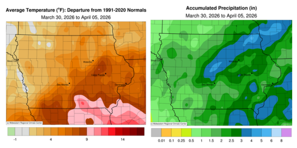
Weather Summary
Provided by Justin Glisan, Ph.D., State Climatologist, Iowa Department of Agriculture and Land Stewardship
The first reporting period of the season was unseasonably warm and wet as an active storm track brought several rounds of showers and thunderstorms, some severe, across Iowa. Temperatures were generally several degrees above average with the warmest conditions over southern Iowa; the statewide average temperature was 48.0 degrees, 4.4 degrees above normal.
Gusty southerly winds helped boost Sunday (29th) afternoon highs into the upper 60s and low 70s with generally clear conditions. Overnight lows at sunrise on Monday (30th) held in the upper 30s northwest to mid 50s southeast. Daytime conditions were well above average with temperatures from the mid 80s to low 90s with blustery winds out of the south; the statewide average temperature was 84 degrees, 30 degrees above normal. Scattered thunderstorms formed from central to eastern Iowa through the evening hours, bringing locally heavy rain, vivid lightning, and small hail. Cedar Rapids (Linn County) reported 0.71 inch, while 1.52 inches were observed in Dallas Center (Dallas County). Tuesday (31ˢᵗ) morning thunderstorms moved out of eastern Iowa as a cold front passed through the state. Wind speeds increased and shifted to a northerly direction, with afternoon conditions varying from the 50s in the north to the upper 60s in the south under mostly sunny skies. Showers moved into southern Iowa after midnight on Wednesday (1ˢᵗ), followed by a brief lull into the late morning hours. Winds also shifted to an easterly direction as a large-scale low-pressure system approached the state. Moderate rainfall became more widespread through the nighttime hours and overnight, with nearly 120 stations observing at least one inch. The highest totals were found across northwest, central and southeastern Iowa; Le Mars (Plymouth County) collected 1.50 inches, Ames (Story County) recorded 1.87 inches, and Earlville (Delaware County) recorded 1.95 inches; the statewide average was 0.86 inch, over 130% of the normal weekly total.
Thursday (2nd) was an active severe weather day for portions of southern and eastern Iowa as a warm front became a focusing mechanism for severe thunderstorms. Afternoon temperatures pushed into the low 70s with dew points in the mid 60s, providing enough instability for all modes of severe weather. Three-inch diameter hail was reported in Martinsburg (Keokuk County) along with an EF-1 tornado with winds approaching 105 mph near Welton (Clinton County). Moderate to heavy rainfall was again reported at many stations with the highest totals in north-central, northeast and a swath of southeast Iowa: New Hampton (Chickasaw County) registered 1.01 inches while Wellman (Washington County) observed 1.57 inches; the statewide average was 0.70 inch. Winds swung back to northerly as the cold front crossed Iowa with morning lows on Friday (3rd) near freezing north to the low 40s south. Another low pressure center moved across the Iowa-Missouri border through the day, producing some morning thundershowers and then some stronger storms in the southwest, ahead of the low’s triple-point. Large hail was observed in southwestern Iowa, but the ingredients for a bigger severe weather outbreak did not come together. Thunderstorms streamed into northern and eastern Iowa as another cold front swept through Iowa. Rainfall totals reported at 7:00 am on Saturday (4th) were exceedingly high within a west-central to northern swath with 1.98 inches in Boone (Boone County) to 4.60 inches in Decorah (Winneshiek County); more than 70 stations observed at least an inch. Afternoon conditions were chilly with a brisk westerly wind and highs in the low 40s under cloud cover. Sunday (5th) dawned with most stations in the upper 20s and low 30s.
Weekly precipitation totals ranged from 0.55 inch in Rock Rapids (Lyon County) to 6.43 inches in Decorah. The statewide weekly average precipitation was 2.31 inches; the normal is 0.65 inch. Clarinda (Page County) reported the week’s high temperature of 91 degrees on the 30th, 33 degrees above normal. Sioux City (Woodbury County) reported the week’s low temperature of 24 degrees on the 30th, six degrees.