Iowa Crop Progress and Condition Report
July 28 - Aug. 3, 2025
DES MOINES, Iowa (Aug. 4, 2025) – Iowa Secretary of Agriculture Mike Naig commented on the Iowa Crop Progress and Condition Report released by the USDA National Agricultural Statistics Service. The report is released weekly April through November. Additionally, the Iowa Department of Agriculture and Land Stewardship provides a weather summary each week during this time.
“After experiencing above-average rainfalls throughout the month, preliminary data shows this will go down as the second wettest July on record with statewide rainfalls averaging over nine inches. Unfortunately, the active weather pattern included a derecho that brought damaging winds to northern and eastern Iowa. Our hearts go out to impacted Iowans as they work to clean up damage to trees, buildings and vehicles, and assess impacts on crops and livestock,” said Secretary Naig. “With the Canadian wildfire smoke clearing out, Iowans will be greeted with seasonal temperatures for the first several days of the world-famous Iowa State Fair.”
The weekly report is also available on the USDA’s website at nass.usda.gov.
Crop Report
Fieldwork activities were limited as rain and wind held Iowa farmers to 3.8 days suitable for fieldwork during the week ending August 3, 2025, according to the USDA, National Agricultural Statistics Service. There were scattered reports of crops damaged or down due to storms, with some crops in low lying areas reportedly impacted by overly wet conditions.
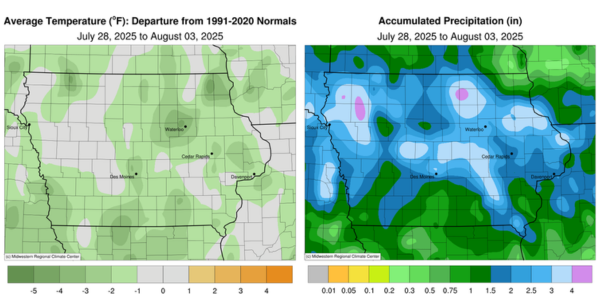
Topsoil moisture condition rated 1 percent very short, 4 percent short, 64 percent adequate and 31 percent surplus. Subsoil moisture condition rated 1 percent very short, 6 percent short, 66 percent adequate and 27 percent surplus.
Corn silking reached 92 percent. Fifty-three percent of Iowa’s corn has reached the dough stage, 2 days ahead of both last year’s pace and the 5-year average. Nine percent of corn reached the dent stage. Corn condition rated 1 percent very poor, 2 percent poor, 12 percent fair, 57 percent good and 28 percent excellent. Soybeans blooming reached 89 percent. Sixty-five percent of soybeans were setting pods, 4 days ahead of last year but 1 day behind average. Soybean condition rated 1 percent very poor, 2 percent poor, 17 percent fair, 59 percent good and 21 percent excellent. Almost all of Iowa’s oats were turning color and 64 percent of oats for grain have been harvested.
The second cutting of alfalfa hay reached 93 percent complete, while 39 percent of the third cutting has been completed. Hay condition rated 84 percent good to excellent. Pasture condition rated 81 percent good to excellent. Some grazing acres were affected by standing water in North Central Iowa.
Weather Summary
Provided by Justin Glisan, Ph.D., State Climatologist, Iowa Department of Agriculture and Land Stewardship
July’s final reporting period began with a derecho speeding through northern and eastern Iowa to a transition back to northwesterly flow, which brought in Canadian wildfire smoke and poor air quality. Weekly precipitation was above average statewide with widespread positive departures in the 1.00 – 3.00-inch range. Temperatures across the state were also below average for the first time in several weeks; the statewide average temperature was 71.0 degrees, 1.5 degrees below normal.
Sunday (27th) afternoon was mostly sunny across Iowa with temperatures in the upper 80s to low 90s and southerly winds. Clouds increased in northern Iowa after midnight as a line of strong thunderstorms pushed south through the state. There were numerous reports of strong straight-line winds over northern Iowa as the line advanced before dissipating after sunrise on Monday (28th) morning in southern Iowa. Many northern stations registered totals in the 0.50- to 1.50-inch range with amounts tailing off farther south. Eastern Iowa locations reported the highest amounts, from 2.10 inches in Waucoma (Fayette County) to 2.48 inches in Asbury (Dubuque County). Clouds cleared through the late morning as sunny skies warmed daytime temperatures into the mid to upper 80s north to south. Later in the evening, severe thunderstorms in South Dakota coalesced into a bow echo that rapidly propagated through northern Iowa. Two spin-up tornadoes were observed near Alvord (Lyon County), producing a swath of damage to acres of corn and soybeans. As the complex, which was later classified as a “derecho” by the Storm Prediction Center, moved into north-central Iowa, it dove southeast and sped across eastern Iowa. There were numerous reports of significant wind gusts along the path length, with 99 mph observed at Sioux Center (Sioux County), 92 mph at both Orange City (Sioux County) and Spencer (Clay County) and 83 mph in Cedar Rapids (Linn County). Rain totals reported at 7:00 am on Tuesday (29th) were also above 0.75 to 1.00 inch along the axis of movement with 1.56 inches in Osage (Mitchell County) to 1.99 inches in Sigourney (Keokuk County). Clearing skies and southerly winds helped boost afternoon temperatures into the 90s over Iowa’s southwestern half with low 80s observed in northeastern Iowa; a stationary boundary was the dividing line, effectively splitting the state.
The surface boundary was a forcing mechanism for an initial line of storms in west-central Iowa through the evening hours. A broader line of thunderstorms developed along a cold front crashing into the warm and humid airmass over Iowa. A widening shield of moderate to heavy rain continued into Wednesday (30th) morning with more than 220 stations reporting at least 1.00 inch and over 50 registering totals over 2.00 inches. A swath of stations from Polk City (Polk County) to Jefferson (Greene County) collected totals from 3.08 inches to 3.62 inches, respectively, with a statewide average of 1.18 inches. Winds shifted to a northerly direction behind the front with pleasant temperatures in the upper 70s and low 80s. Morning lows on Thursday (31st) dropped into the low 60s with patchy fog and haze reported at many stations; wildfire smoke moved into the state as high pressure over the Upper Midwest dominated the flow. Afternoon highs held in the low to mid 70s with light northeasterly winds. Air quality degraded overnight as upper level smoke mixed down to the lower atmosphere through Friday (1st). Daytime temperatures were again five to 10 degrees below average, ranging from the low 70s west to upper 70s east. Morning lows on Saturday (2nd) varied from the low 50s northwest to low 60s southeast with light and variable winds under hazy skies. Daytime temperatures remained unseasonably cool and similar to the previous day. Sunday (3rd) dawned chilly with lows in the 50s and smoky skies.
Weekly precipitation totals ranged from 0.44 inch at Lansing (Allamakee County) to 5.00 inches in Orange City. The statewide weekly average precipitation was 2.18 inches, more than double the normal of 0.95 inch. Carroll (Carroll County) reported the week’s high temperature of 99 degrees on the 29th, 15 degrees above normal. Iowa Falls (Hardin County) reported the week’s low temperature of 48 degrees on the 1st, 14 degrees below normal.