Iowa Crop Progress and Condition Report
April 1 - 7
DES MOINES, Iowa (April 8, 2024) — Iowa Secretary of Agriculture Mike Naig commented on the Iowa Crop Progress and Condition Report released by the USDA National Agricultural Statistics Service. The report is released weekly April through November. Additionally, the Iowa Department of Agriculture and Land Stewardship provides a weather summary each week during this time.
“Soil temperatures are slowly warming up, the crop insurance coverage window will soon be opening, and a more active weather pattern is helping to replenish some soil moisture,” said Secretary Naig. “This time of year, nothing can eclipse farmers’ focus on getting ready for planting once conditions are favorable.”
The weekly report is also available on the USDA’s website at nass.usda.gov.
Crop Report
Another week of colder than normal temperatures with rain and snow left Iowa farmers with 2.8 days suitable for fieldwork during the week ending April 7, 2024, according to the USDA, National Agricultural Statistics Service. Minimal fieldwork was done during the week, but some producers were able to apply anhydrous, manure, and dry fertilizer. High winds prevented producers from spraying fertilizer towards the end of the week.
Topsoil moisture condition rated 14 percent very short, 35 percent short, 47 percent adequate and 4 percent surplus. Subsoil moisture condition rated 26 percent very short, 38 percent short, 34 percent adequate and 2 percent surplus.
Oats seeding reached 32 percent complete, 6 days ahead of last year and 1 week ahead of the 5-year average. Oats emerged reached 4 percent complete.
There were no reports of cattle turned out onto pasture yet as pastures continue to green up. Calving was in full swing with reports of mud in some areas.
Weather Summary
Provided by Justin Glisan, Ph.D., State Climatologist, Iowa Department of Agriculture and Land Stewardship
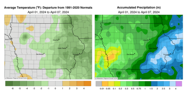
April began unseasonably cool with several windy days across Iowa. Temperatures were near normal in western Iowa and four degrees below average east; Iowa’s average temperature was 42.1 degrees, 1.8 degrees below normal. Eastern Iowa experienced above-average precipitation in the range of 125 to 400% of normal, while the southwest corner was unseasonably dry.
Thunderstorms began firing into the afternoon hours of Sunday (31st) over southeast Iowa with some becoming severe-warned; there were a handful of 1.00-inch hail reports in Lee and Van Buren Counties. Heavier rain was also reported in these storms with several stations collecting more than an inch of moisture; Fairfield (Jefferson County) measured 1.02 inches while Moulton (Davis County) observed 1.62 inches. Lighter showers formed over northern Iowa into Monday (1st) morning with additional storms forming to the southeast. There was a wide range of afternoon highs with upper 30s north to the mid to upper 50s south along with fog and mist. Winds shifted to a northerly direction after midnight with widespread showers across Iowa as a low-pressure center propagated northeast through Missouri. Rain totals reported at 7:00am on Tuesday (2nd) indicated that most stations accumulated at least 0.20 inch with nearly 100 southeastern stations collecting 0.50 inch or more; several Bloomfield (Davis County) gauges had totals ranging from 0.98 inch to 2.70 inches with a statewide average of 0.43 inch. Precipitation gradually tapered off as clouds thinned in western Iowa, where low to mid 50s were present. Temperatures remained in the low 30s farther east as snow showers wrapped in behind the low-pressure center. Snow accumulated at 130 stations with totals ranging from 0.1 inch in Clive (Polk County) to 5.7 inches in Dubuque (Dubuque County). Spotty rain and snow showers continued into Wednesday (3rd) as strong northerly winds built in across the state with sustained winds in the 20-40 mph range; airports in Algona (Kossuth County) and Cedar Rapids (Linn County) reported 52-mph wind gusts. Clouds cleared west to east with daytime temperatures in the 50s where the sun was visible. Precipitation gradually pushed out of eastern Iowa into the evening hours with Bellevue Lock and Dam (Jackson County) collecting 3.0 inches of snow along with an additional 0.50 inch of rain in Bloomfield.
Overnight lows into Thursday (4th) dropped into the upper 20s and low 30s in western Iowa where stars were present. Persistent cloud cover in eastern Iowa held temperatures in the mid 30s. Overcast conditions remained through the day across Iowa’s eastern half with mid to upper 40s and gusty northerly winds; conditions were clear and up to 10 degrees warmer farther west. Winds decreased as the sun set, becoming light and variable into Friday (5th) with lows in the upper 20s in central and northern Iowa. Easterly winds increased through the day with sunny skies and afternoon temperatures in the 50s to low 60s east to west. Gusty southeasterly winds returned on Saturday (6th) as a strong low-pressure center approached from the west. Daytime temperatures were the warmest of the week with some stations in the upper 60s while widespread upper 50s and low 60s were reported. A thin line of thundershowers formed in the evening hours in west-central Iowa followed by a broader swath of showers overnight into Sunday (7th). Rain totals were generally under 0.20 inch though amounts approaching 0.50 inch were found in north-central Iowa.
Weekly precipitation totals ranged from 0.03 inch in Audubon (Audubon County) to 4.40 inches in DeWitt (Clinton County). The statewide weekly average precipitation was 1.02 inches, almost double the normal of 0.66 inch. Sioux City Airport reported the week’s high temperature of 69 degrees on the 6th, 11 degrees above average. Elkader (Clayton County) reported the week’s low temperature of nine degrees on the 6th, 10 degrees below normal. Four-inch soil temperatures ranged from the low 40s north to upper 40s south as of Sunday.
