Iowa Crop Progress and Condition Report
May 26 – June 1, 2025
DES MOINES, Iowa (June 2, 2025) — Iowa Secretary of Agriculture Mike Naig commented on the Iowa Crop Progress and Condition Report released by the USDA National Agricultural Statistics Service. The report is released weekly April through November. Additionally, the Iowa Department of Agriculture and Land Stewardship provides a weather summary each week during this time.
“Planting is nearly complete across the state and most of the corn and soybeans have emerged. Many farmers are now turning their attention to applying crop protection products and baling hay,” said Secretary Naig. “While haze from Canadian wildfires has hung around the last few days, it’s expected to clear by mid-week. The forecast shows much of the state could receive some welcome rain in the week ahead.”
The weekly report is also available on the USDA’s website at nass.usda.gov.
Crop Report
Dry weather with isolated showers led to 5.4 days suitable for fieldwork during the week ending June 1, 2025, according to the USDA, National Agricultural Statistics Service. Primary field activities included planting, cutting hay and spraying emerging crops.
Topsoil moisture condition rated 5 percent very short, 23 percent short, 70 percent adequate and 2 percent surplus. Subsoil moisture condition rated 5 percent very short, 27 percent short, 65 percent adequate and 3 percent surplus.
Corn planted reached 97 percent. Corn emerged reached 87 percent, 6 days ahead of last year’s pace and 1 day ahead of normal. Corn condition rated 84 percent good to excellent. Ninety-six percent of the expected soybean crop has been planted. Soybeans emerged reached 79 percent, 10 days ahead of last year and 4 days ahead of normal. Soybean condition rated 81 percent good to excellent. Ninety-five percent of the State’s oat crop has emerged. Oats headed reached 41 percent, 2 days ahead of last year and 1 week ahead of normal. Oat condition rated 85 percent good to excellent.
Sixty-one percent of the State’s first cutting of alfalfa hay has been completed, 6 days ahead of last year and average. Hay condition rated 83 percent good to excellent. Pasture condition rated 73 percent good to excellent.
Weather Summary
Provided by Justin Glisan, Ph.D., State Climatologist, Iowa Department of Agriculture and Land Stewardship
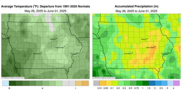
Upper level wildfire smoke produced a copper-colored Sun on several days during the reporting period, slightly reducing incoming solar radiation. Along with persisting cloud cover mid-week, air temperatures remained cooler than normal for the end of May; the statewide average temperature was 62.2 degrees, 2.4 degrees below normal. Rainfall totals were generally light across the state with scarce amounts in south-central and eastern Iowa.
Showers moving across southern Iowa dissipated by noon on Sunday (25th), leaving behind totals generally under 0.10 inch; Pacific Junction (Mills County) reported more than double this amount at 0.22 inch. Most of Iowa reported clear conditions into Monday (26th) morning with lows ranging from the upper 40s north to mid 50s south. Clouds began to increase over southwestern Iowa during the late morning with mostly cloudy skies developing statewide toward the evening hours as temperatures reached into the upper 60s and low 70s. Showers developed across western Iowa into Tuesday (27th) as a cut-off low pressure system stalled over the Upper Midwest. Overcast skies and rain persisted through the day with high temperatures ranging from the upper 50s northwest to low 70s southeast. Light rain tapered off overnight into Wednesday (28th) with cloudy morning conditions and temperatures in the 50s. Event rain totals were highest in western Iowa with 0.51 inch at Sioux City Airport (Woodbury County) to 0.64 inch in Bedford (Taylor County). Many stations receiving rainfall had general amounts in the 0.20-0.40-inch range with lesser amounts farther east. Unsettled conditions continued through the daylight hours with high temperatures in the 60s and light, northerly winds. Patchy fog formed in central to western Iowa early on Thursday (29th) with clouds hanging over much of northern Iowa. Peeks of sunshine were visible here and there towards the evening with temperatures warming into the upper 60s and low 70s with some scattered light showers. Wind shifted to a northwesterly direction into Friday (30th), ushering Canadian wildfire smoke into the region. Wind speeds increased across the state with temperatures breaching the 80 degrees mark across southeastern Iowa; conditions held in the upper 70s over the rest of Iowa with ample sunshine. Saturday (31st) was an ideal day for Iowans with light and variable winds, comfortable relative humidity and highs in the low 80s. Sunday (1st) morning dawned with lows in the 50s and upper level smoke producing a beautiful sunrise.
Weekly precipitation totals ranged from no accumulation at multiple stations in east-central Iowa to 0.79 inch in Remsen (Plymouth County). The statewide weekly average precipitation was 0.21 inch; the normal is 1.08 inches. Several southwest stations reported the week’s high temperature of 88 degrees on the 31st, on average nine degrees above normal. Multiple northern Iowa stations reported the week’s low temperature of 40 degrees on the 26th and 27th, on average 12 degrees below normal.