Iowa Crop Progress and Condition Report
June 16 – 22
DES MOINES, Iowa (June 23, 2025) – Iowa Secretary of Agriculture Mike Naig commented on the Iowa Crop Progress and Condition Report released by the USDA National Agricultural Statistics Service. The report is released weekly April through November. Additionally, the Iowa Department of Agriculture and Land Stewardship provides a weather summary each week during this time.
“Last week’s mix of hot temperatures, high humidity and blustery winds really made it feel like summer. Some areas across north-central Iowa received several inches of rain with other locations receiving uninvited hail and high winds,” said Secretary Naig. “The warmer temperatures and increased chances for rain are likely to continue through the end of the month.”
The weekly report is also available on the USDA’s website at nass.usda.gov.
Crop Report
Spotty precipitation, heavy in some areas, limited Iowa farmers to 4.3 days suitable for fieldwork during the week ending June 22, 2025, according to the USDA, National Agricultural Statistics Service. Field work included cutting hay and spraying. Above average temperatures spurred crop growth.
Topsoil moisture condition rated 3 percent very short, 16 percent short, 73 percent adequate and 8 percent surplus. Subsoil moisture condition rated 6 percent very short, 21 percent short, 65 percent adequate and 8 percent surplus.
Virtually all of Iowa’s corn crop has emerged, and there were scattered reports of corn silking. Corn condition rated 1 percent very poor, 2 percent poor, 14 percent fair, 62 percent good and 21 percent excellent. Nearly all of the soybean crop has emerged. Soybeans blooming reached 13 percent, 5 days ahead of both last year and the five-year average. Soybean condition rated 1 percent very poor, 3 percent poor, 19 percent fair, 61 percent good and 16 percent excellent. Iowa’s oat crop reached 81 percent headed with 27 percent turning color. Oat condition rated 0 percent very poor, 2 percent poor, 13 percent fair, 67 percent good and 18 percent excellent.
At 94 percent, the first cutting of alfalfa hay was nearly complete. The second cutting reached 24 percent complete. Hay condition rated 80 percent good to excellent. Pasture condition rated 72 percent good to excellent. Some heat stress was reported in livestock.
Weather Summary
Provided by Justin Glisan, Ph.D., State Climatologist, Iowa Department of Agriculture and Land Stewardship
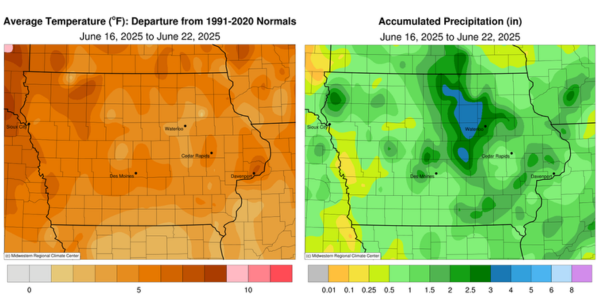
An active storm track over the Upper Midwest allowed for several days of thunderstorms across Iowa. Northern and eastern Iowa reported above-normal rainfall, particularly north-central stations. Temperatures also ramped up through the end of the reporting period with positive departures across the state; the statewide average temperature was 75.9 degrees, 4.8 degrees above normal.
Morning thunderstorms in western Iowa dissipated into Sunday (15th) afternoon as temperatures warmed into the upper 70s and low 80s. Showers and thunderstorms reformed in central and eastern Iowa during the evening hours with another pulse of development in north-central Iowa towards daybreak on Monday (16th). This complex moved southeast over eastern Iowa for much of the day as severe thunderstorms fired in western Iowa during the late afternoon. The line became severe-warned as it raced through west-central Iowa, but lost strength as it fanned out into central and southwest Iowa by sunset. Rain totals reported at 7:00 am on Tuesday (17th) were highest in northern Iowa, where Nora Springs (Floyd County) observed 2.28 inches while Lake Mills (Winnebago County) collected 3.25 inches. Several surrounding stations reported 1.00 inch or more with a north-central to southeast swath of at least 0.50 inch. Much of western Iowa also registered 0.25 to 0.50 inch. Morning conditions were clear with light and variable winds and temperatures in the mid to upper 60s. Afternoon temperatures varied from the upper 70s northwest to upper 80s southeast as scattered showers and thunderstorms returned to much of the state. Slow-moving thunderstorms brought heavier rain to northern Iowa, especially around Orange City (Sioux County) where several gauges registered from 1.58 inches to 3.02 inches. Rainfall continued into Wednesday (18th) with overcast skies across southern and eastern Iowa holding temperatures in the mid to upper 60s. Persisting clouds and rain held daytime temperatures in the 70s as thundershowers rumbled across central Iowa. Conditions quieted down after midnight with clearing skies, westerly winds and morning lows in the upper 50s to mid 60s. Rain amounts for the previous 24 hours were particularly high in southeastern Iowa where a 2.59-inch reading was collected in Ottumwa (Wapello County) and a 3.65-inch reading in Drakesville (Davis County).
Thursday (19th) afternoon conditions warmed into the mid 80s to low 90s under a clear sky and gradually shifting southerly winds. Clouds increased towards the later evening hours with thunderstorms forming in central Iowa as well as an isolated severe-warned cell in southwest Iowa; a 74-mph wind gust was observed near Tabor (Mills County). Another severe-warned line dove south, from Kossuth County into east-central Iowa by sunrise on Friday (20th). Along this swath, numerous stations reported over 0.75 inch with locally heavy totals at north-central and east-central stations; Mason City (Cerro Gordo County) hit 2.43 inches with 3.00 inches in Grinnell (Poweshiek County). Thunderstorms with downpours continued across eastern Iowa before moving out of the state by evening. Afternoon temperatures rapidly warmed into the upper 90s in western Iowa with 80s farther east as southerly winds increased. Strong southerly winds continued overnight into Saturday (21st) helping set several record warm low temperatures for the date; the National Weather Service office in Davenport (Scott County) hit 82 degrees with a statewide low of 72 degrees, 11 degrees above normal. Exceedingly warm daytime temperatures in concert with high dewpoints and sustained strong southerly winds produced anomalous conditions not seen at many locations in the observational record. Conditions were near identical into Sunday (22nd) morning with clear skies and temperatures in the upper 70s.
Weekly rainfall ranged from 0.06 inch at Logan (Harrison County) to 4.41 inches at a Community Collaborative Rain, Hail and Snow (CoCoRaHS) network gauge in Mason City. The statewide weekly average precipitation was 1.82 inches; the normal is 1.19 inches. Little Sioux (Harrison County) reported the week’s high temperature of 101 degrees on the 20th, 17 degrees above normal. Oelwein (Fayette County) reported the week’s low temperature of 50 degrees on the 18th, 11 degrees below normal.