Iowa Crop Progress and Condition Report
Sept. 1-7, 2025
DES MOINES, Iowa (Sept. 8, 2025) – Iowa Secretary of Agriculture Mike Naig commented on the Iowa Crop Progress and Condition Report released by the USDA National Agricultural Statistics Service. The report is released weekly April through November. Additionally, the Iowa Department of Agriculture and Land Stewardship provides a weather summary each week during this time.
“We've heard some initial reports of farmers picking corn this past week in pockets of Iowa. Some early varieties of corn have started to turn quickly due to the dry August,” said Secretary Naig. “This past week’s cooler weather is expected to give way to some mid-September heat, with temperatures likely climbing back into the upper 80s and low 90s by this weekend.”
The weekly report is also available on the USDA’s website at nass.usda.gov.
Crop Report
Mostly dry conditions allowed Iowa farmers 6.0 days suitable for fieldwork during the week ending September 7, 2025, according to the USDA, National Agricultural Statistics Service. Disease pressure in row crops remained a concern to producers. Field activities included cutting and baling hay and harvesting corn silage.
Topsoil moisture condition rated 2 percent very short, 13 percent short, 75 percent adequate and 10 percent surplus. Subsoil moisture condition rated 1 percent very short, 9 percent short, 79 percent adequate and 11 percent surplus.
Ninety-seven percent of Iowa’s corn reached the dough stage. Eighty percent of corn was dented or beyond, 5 days ahead of last year, but equal to the five-year average. Twenty-six percent of corn has matured. Corn condition rated 1 percent very poor, 4 percent poor, 15 percent fair, 57 percent good and 23 percent excellent. Soybeans setting pods reached 98 percent. Soybeans coloring advanced to 44 percent, 2 days ahead of last year but 1 day behind average. Eleven percent of the soybeans were dropping leaves. Soybean condition rated 1 percent very poor, 3 percent poor, 20 percent fair, 58 percent good and 18 percent excellent.
The third cutting of alfalfa hay reached 93 percent complete. Pasture condition rated 71 percent good to excellent.
Weather Summary
Provided by Justin Glisan, Ph.D., State Climatologist, Iowa Department of Agriculture and Land Stewardship
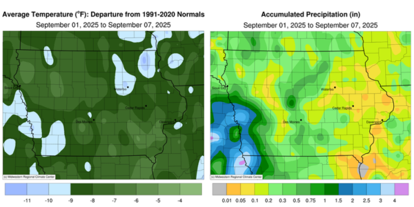
Unseasonably cool temperatures blanketed Iowa during the first reporting period of September, with negative departures approaching 10 to 12 degrees from southwest to northeast; the statewide average temperature was 59.5 degrees, 8.0 degrees below normal. Dry conditions also persisted across most of Iowa, though stations in the southwest reported unseasonably wet conditions.
Rain continued over southwest Iowa through Sunday (31st) and into Monday (1st) as a nearly stationary low pressure system spun over Nebraska and Kansas. Morning temperatures held in the low 60s under cloud cover, with low 50s reported in eastern Iowa, where skies were clear. Showers finally dissipated by mid-afternoon, with overall rainfall totals confined to western Iowa. Southwestern stations collected the highest amounts, with nearly 15 stations reporting at least 2.00 inches; Pacific Junction (Mills County) registered 2.01 inches, while Mondamin (Harrison County) observed 4.02 inches, nearly a month’s worth of rain. Amounts farther east and north were confined to a few tenths of an inch or less. Tuesday (2nd) began with patchy fog across much of the state and lows in the 50s. Partly cloudy skies continued through the daytime hours as scattered showers and a few thunderstorms developed in northeastern Iowa. Additional showers formed in northwestern Iowa along a cold front after sunset, with stronger thunderstorms firing in central Iowa by daybreak on Wednesday (3rd). Winds shifted northwesterly through the day as the cold front dropped southeast, with scattered showers moving through southern Iowa. The front exited southern Iowa by the evening hours, with widespread event totals across the state. Most stations reporting measurable precipitation observed between 0.20 and 0.40 inch, with the highest amounts ranging from 0.60 inch in Waukee (Dallas County) and 0.78 inch in Lovilia (Monroe County) to 0.94 inch in Charles City (Floyd County). Skies cleared after midnight, with light westerly winds and temperatures dropping into the upper 30s and 40s.
Thursday (4th) was blustery for Iowans, with gusty southwesterly winds, mostly sunny skies, and highs in the upper 60s and low 70s. A fast-moving low-pressure center transiting Minnesota brought showers to northern Iowa later in the evening before moving out of the state by midnight. Most stations reported less than a tenth of an inch, with northwest to north-central stations observing totals ranging from 0.25 inch in Lake Mills (Winnebago County) to 0.50 inch in Le Mars (Plymouth County). Friday (5th) was a windy and unseasonably cool day, with cloudy conditions over northern Iowa and highs in the upper 50s. Skies over southern Iowa were less cloudy, allowing temperatures to reach the mid to upper 60s; the statewide average high was 65 degrees, 14 degrees below normal. Saturday (6th) was a pleasant day for the Cy-Hawk football game at Jack Trice Stadium in Ames (Story County). Game-time temperatures were in the mid-60s under partly cloudy skies and northwesterly winds. Starry skies were visible into Sunday (7th) as winds became light and variable, with lows in the upper 30s and low 40s. The statewide average low was 40 degrees, 15 degrees below normal.
Weekly precipitation totals ranged from no accumulation at several western stations to 4.05 inches in Mondamin. The statewide weekly average precipitation was 0.39 inch, while the climatological normal is 0.86 inch. Washington (Washington County) reported the week’s high temperature of 83 degrees on the 2nd, two degrees above normal. Stanley (Buchanan County) reported the week’s low temperature of 32 degrees on the 7th, which was 19 degrees below normal.