Iowa Crop Progress and Condition Report
Oct. 30 - Nov. 5, 2023
DES MOINES, Iowa (Nov. 6, 2023) — Iowa Secretary of Agriculture Mike Naig commented on the Iowa Crop Progress and Condition Report released by the USDA National Agricultural Statistics Service. The report is released weekly April through November. Additionally, the Iowa Department of Agriculture and Land Stewardship provides a weather summary each week during this time.
“Corn and soybean harvest is beginning to wind down thanks to more agreeable weather, though there is still plenty of farm and field work left to finish up yet this fall,” said Secretary Naig. “While statewide drought remains a concern heading into the 2024 growing season, the bursts of October rain helped improve soil moisture in parts of northwestern and eastern Iowa.”
The weekly report is also available on the USDA’s website at nass.usda.gov.
Crop Report
Colder than normal temperatures but dry weather led to 6.0 days suitable for fieldwork during the week ending November 5, 2023, according to the USDA, National Agricultural Statistics Service. Fieldwork included harvesting corn and soybeans, completing fall tillage, applying fall fertilizer, baling stalks, and hauling manure.
Topsoil moisture condition rated 15 percent very short, 40 percent short, 44 percent adequate and 1 percent surplus. Subsoil moisture condition rated 27 percent very short, 43 percent short, 29 percent adequate and 1 percent surplus. Corn harvested for grain reached 89 percent statewide, a day ahead of last year and 10 days ahead of the 5-year average.
Moisture content of field corn being harvested for grain was at 16 percent. Soybeans harvested reached 97 percent, on pace with last year but 9 days ahead of the average.
Livestock reports included calves being weaned and cattle being turned out onto stalk fields.
Weather Summary
Provided by Justin Glisan, Ph.D., State Climatologist, Iowa Department of Agriculture and Land Stewardship
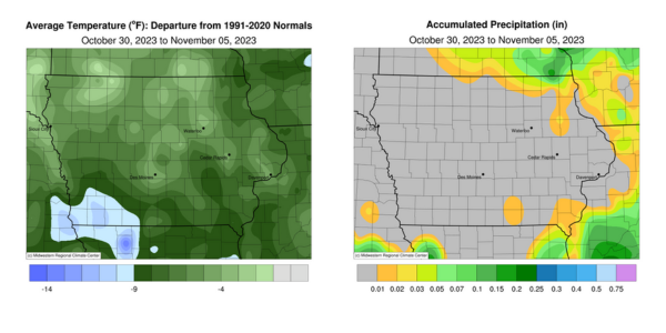
A generally quiet weather pattern set up over Iowa as measurable precipitation was only reported at northern and southeastern stations. Unseasonably cold conditions also blanketed the Upper Midwest with negative departures of up to 10 degrees reported across southwestern Iowa; the statewide average temperature was 36.5 degrees, 7.5 degrees below normal.
Gusty northwesterly winds and overcast skies held daytime temperatures in the mid-30s to low 40s through Sunday (29th) afternoon with a statewide average high of 38 degrees, 18 degrees below normal. Light rain and some snowflakes were observed in southeastern Iowa with 0.02 inch of rain reported at Rathbun Dam (Appanoose County). Clouds cleared through the evening with additional spotty clouds filtering through central Iowa into Monday (30th) morning as the first widespread killing freeze was reported; lows ranged from the upper teens northwest to mid-30s southeast. Stronger westerly winds developed into the afternoon as daytime temperatures rose into the upper 30s and low 40s. A southerly shifting wind signaled a fast-moving low pressure center that brought spotty snow showers across northern Iowa overnight into Tuesday (31st). Several stations measured at least a trace with 0.1 inch in Elkader (Clayton County) to 0.9 inch at Waukon (Allamakee County) as winds returned to a gusty northwesterly direction. Halloween trick-or-treaters were greeted with temperatures in the upper 20s and low 30s as clouds cleared western Iowa. Starry skies persisted into Wednesday (1st) with clouds increasing after daybreak in northwest Iowa. Strong southerly winds helped boost temperatures into the low 50s west while across the state, mid 40s were observed where clouds were present.
Clear conditions and light, variable winds allowed morning lows on Thursday (2nd) to drop into the 20s with a few locations in the low 30s. Under sunny skies, a range of afternoon temperatures was reported with upper 40s in northern Iowa to upper 50s farther south and west. Overnight lows into Friday (3rd) rose as a warm front lifted north across Iowa with upper 40s and low 50s over Iowa’s southern half. A weak low pressure center pushed across the state through the day as light rain showers formed in southeastern Iowa; Keokuk Lock and Dam (Lee County) measured a 0.01-inch total with 0.02 inch in Mount Pleasant (Henry County). Afternoon temperatures hovered in the 50s with winds turning northerly as the low pressure system exited Iowa. Patchy fog was reported on Saturday (4th) morning with lows dropping into the 30s by sunrise. Daytime conditions were pleasant under clear skies with temperatures in the upper 50s and low 60s; the statewide average high was 59 degrees, six degrees warmer than normal. Clouds moved into central Iowa early on Sunday (5th) with fog forming in southeastern Iowa, where temperatures were in the low to mid-30s. Slightly warmer temperatures were observed in northwestern Iowa where low to mid-40s were present.
Weekly precipitation totals ranged from no accumulation at most of Iowa’s stations to 0.07 inch at stations in Allamakee and Winneshiek Counties. The statewide weekly average precipitation was 0.03 inch, while the normal is 0.56 inch. Sioux City Airport (Woodbury County) reported the week’s high temperature of 64 degrees on the 4th, 11 degrees above normal. Audubon (Audubon County) reported the week’s low temperature of 11 degrees on the 1st, 20 degrees below normal.