Iowa Crop Progress and Condition Report
July 12 – 18, 2021
DES MOINES, Iowa (July 19, 2021) — Iowa Secretary of Agriculture Mike Naig commented today on the Iowa Crop Progress and Condition report released by the USDA National Agricultural Statistics Service. The report is released weekly from April through November.
“The majority of Iowa received rain this past week, which is critically important as cornfields are tasseling,” said Secretary Naig. “Unfortunately, with the precipitation came periods of severe weather. Preliminary estimates indicate 26 tornadoes touched down on Wednesday, which is the third highest daily count on record.”
The weekly report is also available on the USDA’s website at nass.usda.gov.
Crop Report
Variable precipitation across Iowa resulted in 4.3 days suitable for fieldwork during the week ending July 18, 2021, according to the USDA, National Agricultural Statistics Service. Days suitable ranged from just 1.6 days in southeast Iowa to 5.3 days in the north central area. There were scattered reports of crop damage due to hail and high winds. Field activities included hauling grain, applying fungicides and insecticides, and harvesting hay and oats.
Topsoil moisture levels rated 6% very short, 27% short, 62% adequate and 5% surplus. Subsoil moisture levels rated 15% very short, 37% short, 46% adequate and 2% surplus.
Producers reported crops responded well to recent rains while indicating more rain is needed. Corn silking or beyond reached 60%, one day ahead of the 5-year average. Corn in the dough stage reached 6%, three days ahead of normal. Iowa’s corn condition was rated 68% good to excellent. Seventy-five percent of soybeans were blooming, 6 days ahead of the five-year average. Thirty percent of soybeans were setting pods, 4 days ahead of normal. Soybean condition was rated 66% good to excellent. Oats coloring reached 85%, 2 days ahead of normal. Almost one-quarter of oats for grain has been harvested, one day ahead of the 5-year average. Iowa’s oat condition improved mariginally to 63% good to excellent.
The second cutting of alfalfa hay reached 63% complete, 3 days behind the 5-year average. There were reports of producers starting on their third cutting of hay. Hay condition rated 59% good to excellent. Pasture condition was rated 45% good to excellent. Some livestock producers were supplementing hay where grass is short, and there were scattered reports of pinkeye in calves.
Weather Summary
Provided by Justin Glisan, Ph.D., State Climatologist, Iowa Department of Agriculture and Land Stewardship
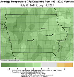
The first half of the reporting period saw an active weather pattern including a tornado outbreak, though most of the tornadoes were on the weaker side. Much of Iowa’s eastern half observed above-average rainfall with some southeastern stations measuring two inches above normal; western Iowa experienced below normal rainfall. Unseasonably cool conditions also blanketed Iowa with the statewide average temperature at 70.6 degrees, 4.4 degrees below normal.
Showers continued to stream into Iowa’s southeastern corner on the backside of a low pressure system for most of Sunday (11th) with three stations in Bloomfield (Davis County) reporting totals between 1.39 inches to 1.82 inches; amounts quickly tapered off to below 0.50 inch northwest. Overnight lows fell into the mid to upper 50s over much of the state’s northwestern half, where skies were clear. Monday (12th) was a cooler than average day with highs in the upper 70s northwest to low 70s southeast where clouds were still present. Overcast conditions persisted in eastern Iowa into Tuesday (13th) morning with dense fog reported at several stations across the state. Morning lows showed quite the range, from the mid to upper 60s east to mid 50s west, where skies were clearing. Winds shifted to a southwesterly direction through the day with highs in the upper 70s and low 80s with partly sunny conditions. Showers and a few storms pushed into western and central Iowa before dissipating during the late evening hours. A broad area of thunderstorms moved into northwestern Iowa around 3:00 am on Wednesday (14th), which would turn out to be a significant weather day. The first wave of rainfall was heavy across northern and eastern Iowa, along with some strong to severe thunderstorms; these storms did not use up all of the atmospheric instability allowing a second, and much stronger area of severe supercell thunderstorms to form in central Iowa during the afternoon. Within a stretch of four hours, several supercells produced tornadoes from Sac City (Sac County) to Canton (Jones County). Most of the tornadoes were rated EF-1 but a strong EF-3 tornado produced crop and property damage along a 10-mile stretch through Lake City (Calhoun County); wind speeds were estimated between 135-145 mph. Preliminarily, there were 26 tornadoes across Iowa, the third highest count for a day since records started in 1980. Thankfully, no injuries or fatalities were reported.
Moderate rainfall continued over Iowa’s southern third through Thursday (15th) as the sluggish system continued east. Clouds gradually cleared with winds shifting to the northwest and daytime temperatures remaining in the low to mid 70s. Rain totals for the event were heaviest in central and eastern Iowa where pockets of one to three inches were reported with over 80 National Weather Service co-op stations measuring an inch or more; Maxwell (Story County) observed 4.40 inches while the statewide average was 1.11 inches. Wildfire smoke from Oregon filtered into the region Friday (16th), lending to hazy skies and striking sunsets through the weekend. Afternoon conditions were seasonal with temperatures in the low 80s under a westerly wind. Overnight lows into Saturday (17th) dipped into the upper 50s and low 60s as mostly sunny skies persisted through the day. Daytime temperatures again were seasonal with variable winds statewide. Upper-level haze continued into Sunday (18th) as morning lows remained in the low to mid 60s.
Weekly precipitation totals ranged from 0.02 inch at Audubon (Audubon County), Perry and Van Meter (Dallas County) to 5.74 inches near Bloomfield (Davis County). The statewide weekly average precipitation was 1.20 inches while the normal is 0.97 inch. Des Moines International Airport (Polk County) and Lamoni (Decatur County) observed the week’s high temperature of 90 degrees on the 14th, on average three degrees above normal. Spencer Municipal Airport (Clay County) reported the week’s low temperature of 50 degrees on the 12th, 13 degrees below normal.