Iowa Crop Progress and Condition Report
Oct. 4 – 10, 2021
DES MOINES, Iowa (Oct. 12, 2021) — Iowa Secretary of Agriculture Mike Naig commented today on the Iowa Crop Progress and Condition report released by the USDA National Agricultural Statistics Service. The report is released weekly from April through November.
“October temperatures continue to be unseasonably warm, which have been beneficial for widespread dry-down in the fields,” said Secretary Naig. “Recent rainfall has slowed down fieldwork across portions of the state, but it is helpful in replenishing some subsoil moisture. Looking ahead, rain continues to be in the forecast over the next several days.”
The weekly report is also available on the USDA’s website at nass.usda.gov.
Crop Report
Scattered precipitation slowed harvest in some areas, but statewide Iowa’s farmers had 5.3 days suitable for fieldwork during the week ending October 10, 2021, according to the USDA, National Agricultural Statistics Service. Field activities included harvesting soybeans and corn, fall tillage and applying fertilizer.
Topsoil moisture levels rated 12 percent very short, 31 percent short, 55 percent adequate and 2 percent surplus. Subsoil moisture levels rated 18 percent very short, 36 percent short, 45 percent adequate and 1 percent surplus.
Ninety-five percent of the corn crop has reached maturity, 8 days ahead of the 5-year average. Close to onethird of corn for grain has been harvested at 30 percent complete statewide, also 8 days ahead of normal. Moisture content of field corn being harvested for grain was 19 percent. Iowa’s corn condition rated 62 percent good to excellent.
Soybeans dropping leaves or beyond reached 96 percent, one week ahead of normal. More than half of Iowa’s soybean crop has been harvested at 56 percent, 9 days ahead of the five-year average. Soybean condition was rated 63 percent good to excellent.
Pasture condition rated 32 percent good to excellent. Overall, livestock were faring well, although conditions varied with some reports of muddy feedlots but also water shortage issues for cattle on pasture.
Weather Summary
Provided by Justin Glisan, Ph.D., State Climatologist, Iowa Department of Agriculture and Land Stewardship
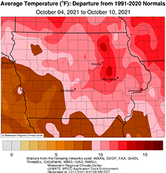
Warmer than average conditions continued across Iowa over the reporting period with positive departures of up to 14 degrees in the state’s northeastern corner. The statewide average temperature was 65.2 degrees, 11.7 degrees above normal. Precipitation behavior flipped from last week as much of eastern Iowa received measurable rainfall while western Iowa reported dry conditions.
Clouds cleared from west to east through Sunday (3rd) afternoon as northerly winds built in with daytime highs remaining in the mid to upper 70s. Under clear skies and light winds, overnight low temperatures ranged from the low 40s northwest to mid 50s southeast with a statewide average low of 50 degrees, five degrees above normal. Cloud cover pushed back into Iowa’s eastern one-third during Monday (4th) morning, holding afternoon highs in the low to mid 70s; clear skies and sunshine warmed temperatures into the upper 70s. With high pressure dominating, the weather pattern remained quiet into Tuesday (5th) with light and variable winds overnight. Scattered morning fog was also reported across northern Iowa stations but quickly burned off as the sun rose. An upper-level disturbance moved through the Midwest over the afternoon hours, shifting winds to an easterly direction and covering the state in mostly cloudy conditions. High temperatures varied from the upper 60s east to upper 70s west with clear skies prevailing in northwestern Iowa. Clouds lingered overnight into Wednesday (6th), holding morning lows in the low to mid 60s, averaging about 10 degrees above normal for early October. Light rain filtered into southeastern Iowa later in the day as a low pressure center spun over Missouri. Additional isolated showers moved into eastern Iowa overnight with rain totals reported at 7:00 am on Thursday (7th) generally below a tenth of an inch; a few stations measured higher totals with Clinton (Clinton County) observing 0.50 inch. Morning lows were well-above average with several stations registering temperatures closer to their climatological high temperatures; the statewide average low was 60 degrees, 17 degrees above normal.
The low pressure center remained cutoff from the upper-level westerly steering flow, slowing down the system appreciably. Waves of showers spun into eastern Iowa through the evening hours with a concentrated area of rain showers covering northeastern Iowa overnight into Friday (8th). The showers finally departed eastern Iowa in the afternoon as skies cleared with daytime temperatures rising into the low 80s; the statewide average high was 80 degrees, 17 degrees above normal. Event rain totals were highest in northeastern Iowa where over 20 stations observed an inch or more; a gauge near New Hampton (Chickasaw County) measured 2.70 inches while a gauge in Waucoma (Fayette County) measured 4.77 inches. Amounts tapered off rapidly farther west with a few tenths of inch in east-central Iowa. Starry skies were visible overnight into Saturday (9th) with patchy morning fog in the northeast. Gusty southeasterly winds increased throughout the day in advance of a strong low pressure system over the Dakotas. Afternoon temperatures were warmer than average with upper 70s and low 80s observed statewide. Rain showers formed along a warm front as it lifted north through eastern Iowa. Rain totals at 7:00 am on Sunday (10th) were very light, amounting to a few one-hundredths, though De Witt (Clinton County) reported 0.20 inch.
Weekly rain totals ranged from no accumulation across much of western Iowa to 4.86 inches in Waucoma. The statewide weekly average precipitation was 0.26 inch while the normal is 0.66 inch. Clarinda (Page County), Little Sioux (Harrison County) and Shenandoah (Page County) observed the week’s high temperature of 86 degrees on the 8th, on average 17 degrees above normal. Guthrie Center (Guthrie County) reported the week’s low temperature of 41 degrees on the 4th, two degrees below normal.

