Iowa Crop Progress and Condition Report
Oct. 11 – 17, 2021
DES MOINES, Iowa (Oct. 18, 2021) — Iowa Secretary of Agriculture Mike Naig commented today on the Iowa Crop Progress and Condition report released by the USDA National Agricultural Statistics Service. The report is released weekly from April through November.
“Warmer than average conditions continued last week, while portions of northern Iowa experienced the first sub-freezing temperatures of the season,” said Secretary Naig. “Widespread rain also fell across the state as harvest progressed at a rapid pace. Outlooks hint at better rain chances through the end of the month.”
The weekly report is also available on the USDA’s website at nass.usda.gov.
Crop Report
Despite measurable precipitation across Iowa, harvest continued as farmers had 4.7 days suitable for fieldwork during the week ending October 17, 2021, according to the USDA, National Agricultural Statistics Service. Field activities continued to include harvesting soybeans and corn, fall tillage and applying fertilizer.
Topsoil moisture levels rated 8 percent very short, 34 percent short, 57 percent adequate and 1 percent surplus. Subsoil moisture levels rated 16 percent very short, 38 percent short, 46 percent adequate and 0 percent surplus.
Virtually all of Iowa’s corn crop has reached maturity. Forty-three percent of corn for grain has been harvested, one week ahead of the five-year average. Moisture content of field corn being harvested for grain was 18 percent. Iowa’s corn condition rated 63 percent good to excellent.
Despite the rain showers, soybean harvest reached 70 percent, one week ahead of the five-year average. Producers in south central Iowa have over half their soybean crop remaining to be harvested while producers in all other districts have at least 52 percent already harvested.
Pasture condition rated 30 percent good to excellent. No unusual conditions for livestock were reported.
Weather Summary
Provided by Justin Glisan, Ph.D., State Climatologist, Iowa Department of Agriculture and Land Stewardship
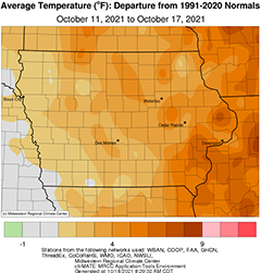
Near-normal to wetter than average conditions were reported statewide as multiple low pressure systems brought widespread rainfall across Iowa. Several southeastern and south-central stations measured totals over 1.50 inches above normal with localized 2.00-inch positive departures. Unseasonably warm temperatures also remained across Iowa with departures above four degrees in eastern Iowa. The statewide average temperature was 54.9 degrees, 2.1 degrees above normal.
A slow-moving cold front sat over eastern Iowa through Sunday (10th) afternoon with showers moving northeast along the boundary. Southerly winds pushed temperatures in the low 80s ahead of the front while highs across the rest of Iowa ranged from the mid 60s to low 70s under mostly sunny skies. A secondary low pressure system pushed into Missouri through the overnight hours, spinning in more showers over the state’s eastern half through Monday (11th). Clear skies in western Iowa kept afternoon highs in the mid 60s and low 70s while upper 50s and low 60s were reported where cloud cover and moderate rain were present. Rain showers dissipated late in the evening as the low pushed into the Great Lakes region as winds shifted to a westerly direction. Morning lows on Tuesday (12th) ranged from the upper 30s west to mid 50s east. Rain totals were generally above 0.25 inch across the state’s southeastern half with isolated pockets at or above one inch; a gauge near Amana (Iowa County) measured 1.00 inch while Rathbun Dam (Appanoose County) observed 1.90 inches. Clouds lingered over northeastern Iowa as sunny skies reigned across the rest of the state with highs reaching into the upper 70s southwest while cooling to the mid 60s east. Easterly winds and cloud cover increased as another potent low pressure center moved into southwestern Iowa overnight into Wednesday (13th), spinning in a line of showers and some strong thunderstorms with vivid lightning and loud thunderclaps. A shield of rain built-in behind the initial line leaving widespread rainfall statewide with moderate to heavy totals reported at many stations in central to eastern Iowa; Des Moines International Airport (Polk County) reported 1.43 inches with Williamsburg (Iowa County) measuring 1.62 inches. All of Iowa’s weather stations experienced measurable rain from the disturbance as nearly 40 stations measured over an inch. General totals for a majority of stations were above 0.50 inch with a statewide average rainfall at 0.54 inch.
Southwesterly winds increased as skies cleared through midnight. Morning lows observed at 7:00 am on Thursday (14th) were chilly in western Iowa with a mix of upper 30s and low 40s. Farther east, temperatures remained in the 50s. Sunshine and light winds remained through the day with afternoon temperatures in the upper 50s in northern Iowa while southern Iowa experienced mid to upper 60s. An upper-level disturbance brought another round of showers through parts of Iowa into the early morning hours of Friday (15th) though rain totals were generally under 0.10 inch. (15th). Daytime highs ranged widely, from the upper 50s northwest to low 70s southeast. Clouds gradually clear through the day as gusty northwest winds held temperatures in the upper 50s and low 60s, a few degrees cooler than average. A large dome of stable high pressure dominated the Midwest, lending to quiet conditions into Saturday (16th). Morning lows were some of the coolest of the season with upper 20s and low 30s reported in northwestern Iowa. Pleasant conditions were experienced across Iowa under brilliant sunshine and light northwesterly winds with highs in the low 60s. Stars were visible prior to sunrise on Sunday (17th) with lows dropping into the 30s and low 40s.
Weekly rain totals ranged from 0.20 inch in Mason City (Cerro Gordo County) to 3.52 inches near Drakesville (Davis County) and in Sigourney (Keokuk County). The statewide weekly average precipitation was 1.13 inches while the normal is 0.56 inch. Oskaloosa (Mahaska County) observed the week’s high temperature of 85 degrees on the 10th, 18 degrees above normal. Sibley (Osceola County) reported the week’s low temperature of 28 degrees on the 17th, seven degrees below normal.