Iowa Crop Progress and Condition Report
Oct. 18 – 24, 2021
DES MOINES, Iowa (Oct. 25, 2021) — Iowa Secretary of Agriculture Mike Naig commented today on the Iowa Crop Progress and Condition report released by the USDA National Agricultural Statistics Service. The report is released weekly from April through November.
“An active weather pattern returned to Iowa this past week, which brought much needed rainfall across the state,” said Secretary Naig. “Soybean harvest continues to make significant progress and should be wrapping up soon despite a soggy forecast.”
The weekly report is also available on the USDA’s website at nass.usda.gov.
Crop Report
Harvest was in full swing across Iowa until precipitation slowed progress over the weekend and limited farmers to 5.0 days suitable for fieldwork during the week ending October 24, 2021, according to the USDA, National Agricultural Statistics Service. Field activities continued to include harvesting soybeans and corn, fall tillage and applying fertilizer.
Topsoil moisture levels rated 7 percent very short, 23 percent short, 63 percent adequate and 7 percent surplus. Subsoil moisture levels rated 14 percent very short, 31 percent short, 53 percent adequate and 2 percent surplus.
Sixty percent of Iowa’s corn for grain has been harvested, one week ahead of the five-year average. Producers across much of the State have approximately two-thirds of their corn crop harvested, while producers in northeast and south central Iowa have more than half remaining to be harvested. Moisture content of field corn being harvested for grain was 18 percent, unchanged from last week.
Soybean harvest reached 83 percent, six days ahead of the five-year average. Although soybean harvest in the southern one-third of the State is still lagging behind, farmers in each of the southern districts harvested 18 percent or more of their soybean crop during the week ending October 24, 2021.
Pasture condition rated 32 percent good to excellent. Livestock were reported to be in good condition with some cattle grazing on stalks. Muddy feedlots may be an issue following rain over the weekend.
Weather Summary
Provided by Justin Glisan, Ph.D., State Climatologist, Iowa Department of Agriculture and Land Stewardship
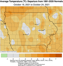
A return to a more active weather pattern brought widespread rainfall across Iowa over the reporting period. Most of Iowa's weather stations reported near-average totals with above-average rain falling in the state's northwest and southwest corners. Warmer than average temperatures persisted statewide though, nowhere near as warm as preceding weeks. The statewide average temperature was 50.5 degrees, 1.7 degrees above normal.
Sunny skies, a light southwesterly wind and daytime highs in the low 70s made Sunday (17th) afternoon very pleasant. Wind shifted to a southerly direction overnight into Monday (18th) as clear skies remained and temperatures hovering in the 40s. A large dome of high pressure over the Mid-Atlantic states kept southerly flow in the pattern, helping boost afternoon temperatures into the upper 70s, up to 19 degrees above average for several northern stations; the statewide average high was 75 degrees, 14 degrees above normal. Skies remained clear into Tuesday (19th) with morning lows in the upper 40s and low 50s with patchy fog observed in southeastern Iowa. Low to mid 70s were reported through the afternoon hours as southerly winds picked up into the evening hours. Cloud cover increased across western Iowa in advance of a low pressure center in northwestern Nebraska that began spinning in scattered rain showers a few hours after midnight on Wednesday (20th). Stronger thunderstorms with isolated pockets of small hail and heavier rain were reported in northwestern Iowa into the late morning hours. As the low’s center of circulation pushed through Iowa, additional pockets of showers with some thundershowers formed in central and eastern Iowa. Winds shifted to a westerly direction behind the low as it exited eastern Iowa early on Thursday (21st) morning. Low temperatures dropped into the 40s with overcast conditions and gusty winds. Much of northern Iowa observed measurable rainfall with totals generally under a few tenths of an inch. Heavier amounts were found in northwestern Iowa with three Lyon County stations reporting over 1.50 inches; a station near Lester reported 1.65 inches while Larchwood measured 2.19 inches.
Gloomy conditions persisted through the afternoon hours with thick stratus clouds blanketing the state. Winds shifted to a northerly direction with daytime high temperatures holding in the mid 40s to low 50s. Western Iowa experienced chilly conditions with clouds clearing overnight into Friday (22nd), marking the first widespread freeze of the season as temperature dipped into the mid to upper 20s. Lows in southeastern Iowa stayed in the low to mid 40s where clouds remained. A fast-moving disturbance brought light showers and isolated reports of graupel (small soft snow pellets) from a northwest to southeast swath of Iowa through the evening hours; precipitation totals were light with Dakota City (Humboldt County) reporting 0.25 inch. Saturday (23rd) saw another cold start to the day with morning lows ranging from the low 20s north to low 40s southeast where partly cloudy skies remained. Mostly sunny skies were present through the afternoon with highs in the mid 50s. Clouds increased from the south later in the evening as a potent low pressure system moved into southern Iowa into early Sunday (24th) morning. Moderate rain fell across much of southern Iowa with the highest 7:00 am totals ranging from 2.21 inches in Randolph (Fremont County) to 2.55 inches at Mount Ayr (Ringgold County); the statewide average rainfall was 0.40 inch.
Weekly rain totals ranged from 0.02 inch in Decorah (Winneshiek County) to 2.84 inches at Fort Madison (Lee County). The statewide weekly average precipitation was 0.65 inch while the normal is 0.59 inch. Multiple stations observed the week’s high temperature of 79 degrees on the 18th and 19th, on average 18 degrees above normal. Elkader (Clayton County) and Mason City Municipal Airport (Cerro Gordo County) reported the week’s low temperature of 23 degrees on the 23rd, on average 11 degrees below normal.

