Iowa Crop Progress and Condition Report
September 26 – October 2, 2022
DES MOINES, Iowa (October 3, 2022) — Iowa Secretary of Agriculture Mike Naig commented today on the Iowa Crop Progress and Condition Report released by the USDA National Agricultural Statistics Service. The report is released weekly April through November.
“Iowa farmers are moving full speed ahead with corn and soybean harvest across the state,” said Iowa Secretary of Agriculture Mike Naig. “Though portions of northern Iowa received its first widespread freeze last week, drier and warmer conditions are expected to persist for the foreseeable future and farmers should remain vigilant about combine and field fire risks.”
The weekly report is also available on the USDA’s website at nass.usda.gov.
Crop Report
Harvest was in full swing with little or no precipitation allowing farmers 6.7 days suitable for fieldwork during the week ending October 2, 2022, according to the USDA, National Agricultural Statistics Service. Fieldwork included harvesting row crops, chopping silage, and some fourth cutting of hay.
Topsoil moisture condition rated 17 percent very short, 36 percent short, 46 percent adequate and 1 percent surplus. Subsoil moisture condition rated 22 percent very short, 35 percent short, 42 percent adequate and 1 percent surplus.
Virtually all of Iowa’s corn crop has reached the dent stage or beyond. Eighty-two percent of Iowa’s corn crop was mature, 1 day behind last year but 4 days ahead of the average. Harvest of the State’s corn crop reached 11 percent complete, 4 days behind last year and 1 day behind the 5-year average. Moisture content of field corn being harvested for grain was at 22 percent. Corn condition dropped slightly to 61 percent good to excellent. Ninety-six percent of soybeans were coloring or beyond. Soybeans dropping leaves were at 80 percent, 4 days behind last year and 1 day behind the 5-year average. Soybean harvest reached 26 percent, 3 days behind last year but 1 day ahead of the average. Farmers in northwest Iowa led the way with 45 percent harvested while farmers in south central Iowa have harvested just 4 percent. Soybean condition fell slightly to 61 percent good to excellent.
Pasture condition dropped to 28 percent good to excellent. Water for cows and calves on pasture continued to be an issue in areas of the State. Weaning was underway for some livestock producers.
Weather Summary
Provided by Justin Glisan, Ph.D., State Climatologist, Iowa Department of Agriculture and Land Stewardship
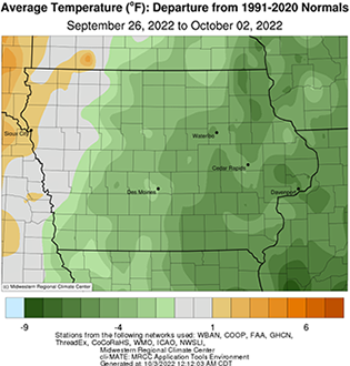
The driest conditions of the growing season were observed over the reporting period with most of Iowa’s National Weather Service stations observing no precipitation. Unseasonably cool temperatures were also reported with below normal departures of up to seven degrees observed in eastern Iowa; the statewide average temperature was 55.1 degrees, 4.0 degrees below normal.
Gusty northwesterly winds continued into Sunday (25th) afternoon under clear skies and seasonally high temperatures in the low to mid 70s. Cloudless skies remained overnight with Monday (26th) morning temperatures in the low to mid 40s as winds died down. Daytime temperatures varied from the low 60s north to low 70s southwest with pockets of partly cloudy skies in western Iowa. Variable winds developed through the nighttime hours with thicker cloud cover over much of the state; eastern Iowa remained clear as low temperatures statewide hovered in the upper 30s to mid 40s where clouds were present. Tuesday (27th) was a mirror-image day, though winds shifted to a northerly direction through the morning hours. Daytime conditions were clear, and temperatures remained in the upper 60s and low 70s. Under starlit skies and light winds, the first freeze of the season occurred across portions of northern Iowa with Wednesday (28th) morning lows dropping into the upper 20s; upper 30s and low 40s were observed farther south; the statewide average low was 34 degrees, 13 degrees below normal. Mid to upper 60s greeted the state through the afternoon with light winds and sunshine. Southeasterly winds built in overnight with temperatures dropping back into the upper 30s and low 40s with some fog and haze reported at stations in south-central Iowa.
Southerly winds developed through Thursday (29th) with mostly sunny conditions and temperatures reaching into the mid 70s west; mid 60s were observed across eastern Iowa. Light and very spotty showers formed in extreme northern Iowa after midnight and continued sporadically through Friday (30th) into the northeastern reaches of the state. The persistent flow out of the south help raise afternoon highs into the upper 70s in western Iowa; temperatures were anywhere from five to ten degrees cooler farther east. Cloud cover increased over northern Iowa into Saturday (1st) morning as isolated showers continued to form in western and northern Iowa, though much of the rainfall evaporated before hitting the ground. The warmest conditions of the week occurred during the late afternoon hours with highs pushing into the upper 70s and low 80s at many stations. Light winds continued into Sunday (2nd) with partly cloudy skies and lows in the upper 40s and low 50s.
Weekly precipitation totals ranged from no accumulation at most Iowa stations to 0.20 inch at Sheldon (O’Brien County) and Spirit Lake (Dickinson County). The statewide weekly average rainfall was 0.01 inch while the normal is 0.71 inch. Sioux Center (Sioux County) reported the week’s high temperature of 83 degrees on the 1st, 11 degrees above normal. Vinton (Benton County) reported the week’s low temperature of 26 degrees on the 28th, 19 degrees below normal.

