Iowa Crop Progress and Condition Report
Oct. 25 – 31, 2021
DES MOINES, Iowa (Nov. 1, 2021) — Iowa Secretary of Agriculture Mike Naig commented today on the Iowa Crop Progress and Condition report released by the USDA National Agricultural Statistics Service. The report is released weekly from April through November.
“Several rounds of steady rain fell across much of Iowa, which improved drought conditions and helped recharge subsoil moisture but slowed harvest progress,” said Secretary Naig. “A shift toward a colder weather pattern will likely bring a widespread killing freeze ending the growing season. Moving forward, dry outlooks could allow farmers to get back into the fields.”
The weekly report is also available on the USDA’s website at nass.usda.gov.
Crop Report
Widespread precipitation slowed or halted harvest across much of Iowa and limited farmers to just 2.7 days suitable for fieldwork during the week ending October 31, 2021, according to the USDA, National Agricultural Statistics Service. Field activities, when possible, included harvesting and fall tillage.
Topsoil moisture levels rated 2 percent very short, 12 percent short, 73 percent adequate and 13 percent surplus. Subsoil moisture levels rated 8 percent very short, 27 percent short, 60 percent adequate and 5 percent surplus. The week’s precipitation helped replenish soil moisture. Eighty-six percent of the State’s topsoil moisture was rated adequate to surplus; the highest percentage of the season.
Seventy percent of Iowa’s corn for grain has been harvested, four days ahead of the five-year average. There were scattered reports of downed corn due to strong winds. Moisture content of field corn being harvested for grain was 17 percent. Only farmers in south central Iowa have more than half of their corn for grain crop remaining to be harvested.
Soybean harvest reached 88 percent, two days ahead of the five-year average. There were several reports of soybeans lodging due to the damp weather. Soybean harvest in the southern one-third of the State continued to lag behind, but farmers in those districts have now harvested close to three-quarters or more of their soybean crop.
Pasture condition rated 31 percent good to excellent. No issues with livestock were reported this week.
Weather Summary
Provided by Justin Glisan, Ph.D., State Climatologist, Iowa Department of Agriculture and Land Stewardship
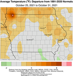
Iowa experienced the wettest reporting period of the growing season as multiple low pressure systems brought widespread and much needed rainfall statewide. All of Iowa’s National Weather Service stations reported above average rainfall with most stations reporting more than two inches above average. Overall weekly average temperatures were near normal across Iowa with slightly warmer conditions over northern Iowa; the statewide average temperature was 46.5 degrees, 0.6 degree above normal.
Moderate to heavy rain fell across Iowa through Sunday (24th) as a strong center of low pressure spun over the state. Overcast skies and persistent rain held afternoon highs in the 40s with low 50s along the Iowa-Missouri border. Gusty northerly winds built in behind as the system pushed out of eastern Iowa into the morning hours on Monday (25th). Rain totals reported at 7:00 am were above 2.00 inches at more than 100 stations with most of Iowa’s reporting stations measuring at least an inch. There were isolated pockets above 3.00 inches in southwest, central and east-central Iowa with Shenandoah (Page County) observing 3.21 inches while a gauge near Murray (Clarke County) collected 3.54 inches; the statewide average 24-hour total was 1.43 inches. Clouds cleared west to east into the afternoon hours with daytime temperatures holding in the mid 50s. Winds shifted to a southwesterly direction by sunrise on Tuesday (26th) with low 30s east under clear skies and mid 40s southwest where clouds began filtering in. Strong winds developed during the day as a second low pressure system approached from the west. Afternoon temperatures were near-seasonal, generally in the mid to upper 50s with clouds creeping farther east. South to north moving showers entered western Iowa into the early morning hours of Wednesday (27th) as the low slowly moved into Missouri. A broader shield of moderate showers formed through the day and continued to bring widespread rainfall over much of Iowa’s western three-quarters. Thick cloud cover held overnight temperatures in the upper 40s and low 50s as the disturbance continued to spin showers into Iowa.
Thursday (28th) was a wet and dreary day as light to moderate rain continued into the evening hours. High temperatures ranged from the mid 50s northwest where clouds started to thin to upper 40s east. Scattered rain showers persisted, mainly over eastern and central Iowa as the low finally exited the region into Friday (29th). Event rain totals were above an inch across the western half of Iowa with widespread amounts approaching 2.00 inches. A pocket of southwest Iowa reported the highest totals with Corning (Adams County) observing 2.00 inches and Randolph (Fremont County) measuring 3.05 inches; the statewide average total was 0.99 inch. Blustery northerly winds and overcast skies remained through the evening hours with gradual clearing in western Iowa; afternoon highs there reached into the upper 50s and low 60s while eastern Iowa held in the low 50s. Sub-freezing temperatures were observed under starry skies across the state’s northwestern half with some stations reporting upper 20s at 7:00 am on Saturday (30th). Sunny skies and light winds led to a pleasant day as temperatures climbed into the upper 50s and low 60s with widespread and vivid fall colors finally emerging. Skies clouded up briefly overnight leading to a range of lows from low 30s northwest to mid 40s southeast. Skies were generally clear at sunset on Sunday (31st) with spotty clouds in eastern Iowa.
Weekly rain totals ranged from 0.37 inch at Decorah Municipal Airport (Winneshiek County) to 5.24 inches in Clive (Polk County). The statewide weekly average precipitation was 2.56 inches, almost five times the normal of 0.55 inch. Sioux City Airport (Woodbury County) reported the week’s high temperature of 68 degrees on the 30th, 13 degrees above normal. Audubon (Audubon County) reported the week’s low temperature of 27 degrees on the 30th, five degrees below normal.