Iowa Crop Progress and Condition Report
Nov. 1 – 7, 2021
DES MOINES, Iowa (Nov. 8, 2021) — Iowa Secretary of Agriculture Mike Naig commented today on the Iowa Crop Progress and Condition report released by the USDA National Agricultural Statistics Service. The report is released weekly from April through November.
“Last month was the eighth wettest October on record,” said Secretary Naig. “A stretch of rainy days helped replenish soil moisture, improving drought conditions that were lingering in the state. Although the precipitation slowed fieldwork, soybean harvest is now nearing completion.”
The weekly report is also available on the USDA’s website at nass.usda.gov.
Crop Report
Warmer temperatures and minimal precipitation allowed Iowa’s farmers 5.6 days suitable for fieldwork during the week ending November 7, 2021, according to the USDA, National Agricultural Statistics Service. Field activities included harvesting, fall tillage, fertilizer and anhydrous applications and baling corn stalks.
Topsoil moisture levels rated 1 percent very short, 14 percent short, 80 percent adequate and 5 percent surplus. Subsoil moisture levels rated 7 percent very short, 26 percent short, 64 percent adequate and 3 percent surplus.
Harvest continued this week and was wrapping up in some parts of the State. Iowa’s corn for grain harvest reached 84 percent complete, 4 days ahead of the five-year average. Moisture content of field corn being harvested for grain was 17 percent. Only farmers in South Central Iowa have over one-quarter of their corn for grain crop remaining to be harvested.
Ninety-five percent of Iowa’s soybean crop has been harvested, 3 days ahead of the five-year average. While soybean harvest is nearly complete in much of the State, farmers in the southwest and south central districts have over 10 percent of their soybean crop still to harvest.
Livestock were reported to be faring well.
Weather Summary
Provided by Justin Glisan, Ph.D., State Climatologist, Iowa Department of Agriculture and Land Stewardship
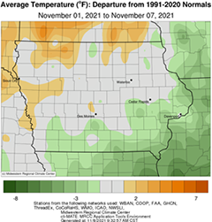
After a stretch of soggy weeks, dry conditions returned to Iowa during the first week of November. While several stations reported measurable precipitation, deficits of 0.40 to 0.60 inch were observed over much of the state. Along with the quiet weather pattern, a range of temperatures were experienced from slightly above average northwest to slightly below average southeast; near-normal conditions in between. The statewide average temperature was 42.6 degrees, 0.9 degree above normal.
Gusty northwesterly winds persisted through Sunday (31st) afternoon with mostly cloudy skies over southwestern Iowa. Daytime highs ranged from the low 50s southeast to mid 40s northwest. Winds shifted to the west overnight as a weak upper-level disturbance brought light rain into the state’s southwest corner with a few snowflakes mixed in. Light showers continued to move through southern Iowa late Monday (1st) morning, though much of the precipitation evaporated before hitting the surface. Several stations reported measurable amounts, however totals were under 0.10 inch; New Market (Taylor County) observed 0.01 inch while College Springs (Page County) measured 0.08 inch. Partly to mostly cloudy skies remained for the rest of the day with chilly afternoon temperatures in the low to mid 40s. Clouds cleared overnight into Tuesday (2nd) with light westerly winds. Morning temperatures were at or below 28 degrees statewide, signaling the end of the growing season as the first widespread killing freeze occurred; temperatures in northwestern Iowa dropped down to upper teens. High pressure would build in over the Midwest during the day and hold the pattern stable across much of the week. Partly sunny skies and highs hovering in the mid 40s were observed into the afternoon hours. Overnight temperatures into Wednesday (3rd) remained in the low 30s through central Iowa where clouds were present with temperatures in the upper teens and low 20s in eastern Iowa under starry skies; the statewide average low was 23 degrees, nine degrees below normal. Winds shifted to a southerly direction during the day but did little to boost temperatures out of the mid to upper 40s as overcast skies blanketed much of Iowa. Light showers pushed across north-central Iowa into the evening with Forest City (Winnebago County) reporting 0.05 inch.
Morning lows reported at 7:00 am on Thursday (4th) were again below normal across much of the state, though around five degrees warmer than the previous morning. Mostly cloudy skies held over northern Iowa with sunshine in southern Iowa, where afternoon temperatures rose into the 50s. Skies cleared through the day on Friday (5th) as southerly winds increased as a weak low pressure center approached from the west. Daytime conditions ranged from mid 50s east to low 60s west with overnight lows hovering in the upper 30s and low 40s. Saturday (6th) was unseasonably warm and pleasant with sunshine and highs in the upper 60s and low 70s. The statewide average high was 65 degrees, 14 degrees above normal. Temperatures at 7:00 am on Sunday (7th) were warmer than average for early November, with lows up to 12 degrees above normal in northern Iowa.
Weekly precipitation totals ranged from no accumulation at most of Iowa’s stations to 0.14 inch in Lamoni (Decatur County). The statewide weekly average precipitation was 0.01 inch while the normal is 0.49 inch. Jefferson (Greene County) and municipal airports in Estherville (Emmet County) and Spencer (Clay County) reported the week’s high temperature of 71 degrees on the 6th, on average 23 degrees above normal. Belle Plaine (Benton County), Elkader (Clayton County) and Fayette (Fayette County) reported the week’s low temperature of 17 degrees on the 3rd; these readings were on average 13 degrees below normal.

