Iowa Crop Progress and Condition Report
April 4 - 10, 2022
DES MOINES, Iowa (April 11, 2022) — Iowa Secretary of Agriculture Mike Naig commented today on the Iowa Crop Progress and Condition Report released by the USDA National Agricultural Statistics Service. The report is released weekly April through November.
“A stagnant weather pattern across the upper Midwest has brought persistent light rain and snow to portions of Iowa over the past week,” said Secretary Naig. “As farmers are eager to begin fieldwork, colder conditions have hindered their efforts. The additional moisture, however, will be beneficial for the upcoming growing season.”
The weekly report is also available on the USDA’s website at nass.usda.gov.
Crop Report
Snow, rain, and cold conditions limited Iowa farmers to 2.0 days suitable for fieldwork during the week ending April 10, 2022, according to the USDA, National Agricultural Statistics Service. Those who have been able to do any fieldwork have been applying anhydrous and fertilizer, spreading manure and planting oats.
Topsoil moisture levels rated 7 percent very short, 21 percent short, 65 percent adequate and 7 percent surplus. Subsoil moisture levels rated 11 percent very short, 31 percent short, 56 percent adequate and 2 percent surplus.
Thirteen percent of the expected oat crop has been planted, 5 days behind last year and 2 days behind the 5-year average. There were scattered reports of oats beginning to emerge.
Below normal temperatures meant pastures remained mostly dormant. Livestock conditions were generally good although cold temperatures and moisture have been a challenge for some cattle producers as calving continues.
Weather Summary
Provided by Justin Glisan, Ph.D., State Climatologist, Iowa Department of Agriculture and Land Stewardship
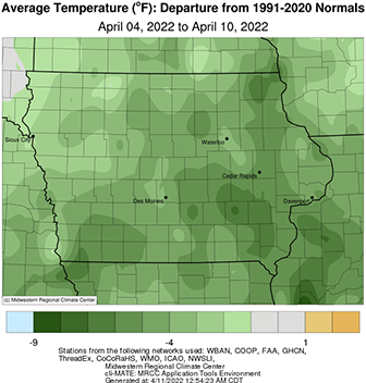
The damp and gloomy conditions that persisted through most of the reporting period finally broke towards the end of the week. Unseasonably cold temperatures continued across Iowa with the statewide average temperature at 40.7 degrees, 3.6 degrees below normal. The cutoff low pressure system that stagnated the weather pattern over the Upper Midwest also brought rounds of showers, both rain and snow, though much of the state experienced precipitation deficits between 0.40 to 0.60 inch.
Pockets of light showers formed in central Iowa with moderate rainfall reported later Sunday (3rd) afternoon as a low pressure center pushed over northern Iowa. Rainfall reports at 7:00 am on Monday (4th) showed much of the state’s southeastern one-third picked up measurable totals, though most reports were under a few tenths of an inch. A swath of heavier totals was found across south-central into the southeastern corner with six stations reporting at least 0.50 inch; Le Claire Lock and Dam (Scott County) measured 0.53 inch while Fort Madison (Lee County) collected 1.02 inches. Overcast skies cleared through the afternoon hours with high temperatures registering in the low to mid 50s with light, variable winds. Southeasterly winds developed overnight into Tuesday (5th) in advance of a low pressure system that would dominate the large-scale flow for the coming days. The low slowly moved from the Dakotas into Minnesota where it became cutoff from the steering flow and remained nearly stationary. Widespread showers formed over Iowa as most stations observed at least a tenth of an inch. Iowa’s eastern quarter measured totals from 0.25 inch to near 1.00 inch in the southeastern counties; a gauge near Burlington (Des Moines County) registered 1.12 inches with a statewide average coming in at 0.21 inch. West-northwesterly flow ushered in gusty winds and pockets of light rain and snowflakes though Wednesday (6th) with highs only reaching into the 40s. Wind speeds diminished somewhat later in the evening as an upper-level weather disturbance produced additional rain and snow showers on the backside of the low pressure spinning into western Wisconsin.
Thursday (7th) was another chilly day with light precipitation falling for most of the day. Iowa’s average afternoon high was 42 degrees, 15 degrees below normal. Precipitation totals were widespread, though under 0.20 inch with Corning (Adams County) measuring 0.7 inch of snow. Morning lows prior to sunrise on Friday (8th) were hovering in the low to mid 30s under thick stratus. Cloud cover finally started to break west to east through the afternoon with northwesterly winds slowing down into the evening hours. Daytime highs rose into the low 50s in extreme western Iowa while upper 30s and 40s were reported farther east. Skies remained clear into Saturday (9th) with morning lows in the teens west to 30s east under a light westerly breeze; the average low was 25 degrees, 10 degrees below normal. A shift to a southerly wind brought the warmest daytime temperatures of the week with upper 50s and low 60s reported across much of Iowa; the statewide average high was 57 degrees, near normal for this time of year. Some stray clouds filtered into central Iowa overnight into Sunday (10th) as winds were on the increase from the southeast. Morning lows remained in the upper 30s north to mid 40 south under mostly clear skies.
Weekly precipitation totals ranged from trace amounts at several stations to 1.54 inches at Maquoketa (Jackson County). The statewide weekly average precipitation was 0.32 inch while the normal is 0.65 inch. Cedar Rapids (Linn County) and Lowden (Cedar County) reported the week’s high temperature of 69 degrees on the 9th, on average nine degrees above average. Little Sioux (Harrison County) reported the week’s low temperature of 16 degrees on the 9th, 16 degrees below normal. Four-inch soil temperatures were in the upper 30s northwest to upper 40s southeast as of Sunday.

